- Napuka
-
Napuka NASA-Bild von Napuka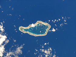
Gewässer Pazifischer Ozean Archipel Tuamotu-Archipel Geographische Lage 14° 12′ S, 141° 15′ W-14.2-141.25Koordinaten: 14° 12′ S, 141° 15′ W 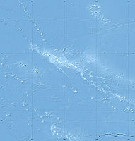

Anzahl der Inseln 30 Landfläche 8 km² Lagunenfläche 18 km² Einwohner 271 (2007) Lage von Napuka (1)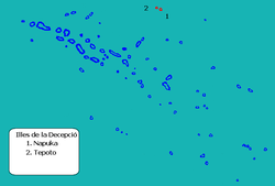
Napuka ist ein Atoll des Tuamotu-Archipel in Französisch-Polynesien. Das Atoll gehört zu den Îles du Désappointement, administrativ zur Gemeinde Napuka. Das nächstgelegene Atoll ist Tepoto Nord, 15 km südöstlich entfernt. Napuka ist 10,5 km lang und 4 km breit. Die Lagune des Atolls bedeckt ca. 18 Quadratkilometer und hat keinen schiffbaren Zugang zum Meer. Sie wird nach Osten flacher.
Geschichte
Das Atoll wurde 1519 durch Ferdinand Magellan entdeckt, der auf dem Atoll sowie auf dem Nachbaratoll Tepoto Nord kein Wasser für seine Weiterfahrt finden konnte. So erhielten die beiden ariden Eilande ihren europäischen Namen Inseln der Enttäuschung.
Mitte des 19. Jahrhunderts wurde das Atoll von der United States Exploring Expedition unter Charles Wilkes aufgesucht und kartiert. Wilkes nannte die Insel Wytoohee Island.
1977 wurde auf dem Atoll ein Flugfeld fertiggestellt. Der bedeutendste Ort der Insel, die fast ausschließlich von Polynesiern bewohnt wird, ist Tepukamaruia oder auch Te Puka Maru Ia.
Weblinks
- Kurzbeschreibung und Bild des Atolls (englisch)
- Census 2007 (PDF, französisch)
- Flughafen Napuka (englisch)
- Herleitung des Atollnamens (englisch)
- Amerikanische Forschungsexpedition (englisch)
- Charles Wilkes (englisch)
- Kirchengeschichte (französisch)

Ahe | Ahunui | Akiaki | Amanu | Anaa | Anuanuraro | Anuanurunga | Apataki | Aratika | Arutua | Faaite | Fakahina | Fakarava | Fangatau | Fangataufa | Gambier | Hao | Haraiki | Héréhérétué | Hikueru | Hiti | Katiu | Kauehi | Kaukura | Makatea | Makemo | Mangareva | Manihi | Manuhangi | Maria Est | Marokau | Marutea Nord | Marutea Sud | Mataiva | Matureivavao | Morane | Motutunga | Mururoa | Napuka | Nengonengo | Niau | Nihiru | Nukutavake | Nukutepipi | Paraoa | Pinaki | Puka-Puka | Puka Rua | Rangiroa | Raraka | Raroia | Ravahere | Reao | Reitoru | Rekareka | Taenga | Tahanea | Taiaro | Takapoto | Takaroa | Takume | Tatakoto | Tauere | Tekokota | Tematangi | Temoe | Tenararo | Tenarunga | Tepoto Nord | Tepoto Sud | Tikehau | Tikei | Toau | Tuanake | Tureia | Vahanga | Vahitahi | Vairaatea | Vanavana
Wikimedia Foundation.
Schlagen Sie auch in anderen Wörterbüchern nach:
Napuka — Napuka … Wikipedia
Napuka — Vue satellite de la NASA Géographie Pays … Wikipédia en Français
Napuka — Localización de las islas de la Decepción en las Tuamotu. Napuka es un atolón de las Tuamotu, en la Polinesia Francesa. Forma parte, junto con Tepoto Norte, de las islas de la Decepción. Administrativamente es la capital de una comuna que incluye … Wikipedia Español
Napuka (Gemeinde) — Napuka ist eine Gemeinde im Tuamotu Archipel in Französisch Polynesien. Die Gemeinde besteht aus einem Atoll und einer Insel. Sie ist in 2 „Communes associées“ (Teilgemeinden) untergliedert. Der Hauptort der Gemeinde ist Napuka. Der Code INSEE… … Deutsch Wikipedia
Napuka Airport — is an airport on Napuka in French Polynesia (IATA: NAU, ICAO: NTGN). The airport is 1 km southeast of Tepukamaruia village. External links NTGN – NAPUKA (PDF). AIP from French Service d information aéronautique, effective 17 Nov 2011.… … Wikipedia
Napuka (commune) — 16° 30′ 22″ S 179° 55′ 10″ W / 16.506139, 179.919403 … Wikipédia en Français
Disappointment Islands — Coordinates: 14°10′S 141°16′W / 14.167°S 141.267°W / 14.167; 141.267 Not to be confused with … Wikipedia
Disappointment Islands — Lage der Atolle Napuka und Tepoto Nord im Tuamotu Archipel (span.) Die Îles du Désappointement (englisch: Disappointment Islands, Inseln der Enttäuschung) sind eine kleine Gruppe von Atollen im Nordosten des Tuamotu Archipels in (Französisch… … Deutsch Wikipedia
Îles du Désappointement — Gewässer Pazifischer Ozean Archipel Tuamotu Archipel Geographische Lage … Deutsch Wikipedia
Tepoto (North) — Tepoto, also known as Te Poto, Toho, or Pukapoto, is a coral island. It is the northwesternmost of the Disappointment Islands, in the Tuamotu Archipelago. Despite being often referred to as atoll , Tepoto is not a typical Tuamotu atoll, but a… … Wikipedia
Napuka


18+
© Academic, 2000-2024
- Kontaktieren Sie uns: Unterstützung, Werbung
Wörterbücher Export, schritte mit PHP, Joomla, Drupal, WordPress, MODx.