Arthur Laing Bridge

Arthur Laing Bridge
49.198888888889-123.13583333333

f1

Arthur Laing Bridge
Arthur Laing Bridge
Arthur Laing Bridge
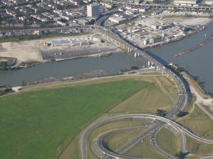
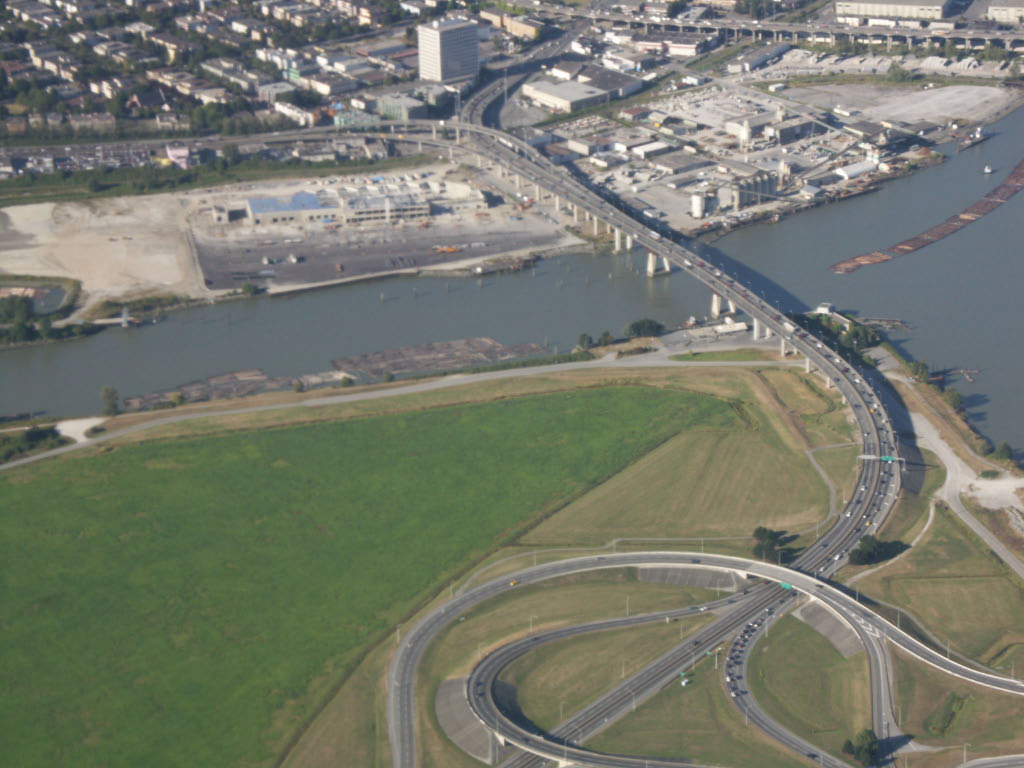
Nutzung Autobahnbrücke
Querung von Fraser River
Ort Vancouver, Sea Island
Konstruktion gevoutete Ausleger-Fachwerkbrücke
Gesamtlänge 1.676 m
Breite 20 m
Längste Stützweite 270 m
Baukosten 23 Mio. CAD
Fertigstellung August 1975
Freigabe 15. Mai 1976

Die Arthur Laing Bridge ist eine vierspurige Brücke in der kanadischen Provinz British Columbia. Sie überbrückt den Fraser River und verbindet Vancouver mit der Insel Sea Island in der Gemeinde Richmond, auf der sich der Vancouver International Airport befindet.

Die heute bestehende Brücke befindet sich an derselben Stelle wie ihr Vorgänger, die Marpole Bridge, ist aber höher und länger. Die Marpole Bridge wurde 1889 gebaut und zwölf Jahre später durch einen Neubau ersetzt. Nach der Eröffnung der weiter östlich gelegenen Oak Street Bridge, die direkt zur Hauptinsel Richmonds – Lulu Island – führt, wurde die Marpole Bridge abgerissen. Der Flughafen konnte nur noch mit einem Umweg erreicht werden. Mit dem Wachstum des Flughafens nahm die Verkehrsbelastung auf der Oak Street Bridge stark zu, was den Bau einer neuen Brücke erforderlich machte.

Am 6. September 1974 gab Premierminister Pierre Trudeau bekannt, dass die neue Brücke nach dem Parlamentsabgeordneten Arthur Laing aus Vancouver benannt werden würde. Die Brücke wurde im August 1975 für den Verkehr freigegeben, die offizielle Eröffnung erfolgte jedoch erst am 15. Mai 1976.

Weblinks


Wikimedia Foundation.

Игры ⚽ Поможем написать курсовую

Schlagen Sie auch in anderen Wörterbüchern nach:

  • Arthur Laing Bridge — The Arthur Laing Bridge is a four lane, high level bridge crossing the North Arm of the Fraser River between Vancouver and Richmond, British Columbia s Sea Island where the Vancouver International Airport is located. Two parallel independent… …   Wikipedia

  • Arthur Laing — PC (9 September 1904 ndash; 13 February 1975) was a Canadian politician. He was a Liberal Member of the Canadian House of Commons from Vancouver, British Columbia.In 1953, he became leader of the British Columbia Liberal Party just before a… …   Wikipedia

  • Oak Street Bridge — Carries Four lanes of British Columbia Highway 99, pedestrians and bicycles Crosses North Arm Fraser River Locale …   Wikipedia

  • Marpole Bridge — The Marpole Bridge is a swing span railway bridge that crosses the north arm of the Fraser River and connects Vancouver with Richmond, British Columbia. The original Marpole Bridge was constructed in 1902. When it was damaged in 1966, a… …   Wikipedia

  • New Westminster Bridge — Fraser River Swing Bridge (below), as seen from the Skybridge. The New Westminster Bridge (also known as the Fraser River Swing Bridge) crosses the Fraser River and connects New Westminster with Surrey, British Columbia, in Canada …   Wikipedia

  • Moray Bridge — Official name Moray Channel Bridge Carries Two lanes of Sea Island Way, pedestrians and bicycles Crosses Middle Arm Fraser Riv …   Wikipedia

  • Dinsmore Bridge — Carries Two lanes of Gilbert Road, pedestrians and bicycles Crosses Middle Arm Fraser River Locale Richmond …   Wikipedia

  • North Arm Bridge — The North Arm Bridge shot from a SkyTrain that has just left the bridge, in Richmond heading to Bridgeport Station. Carries Two tracks of the Canada Line and a pedestrian and bike pathway attached beneath and beside the tra …   Wikipedia

  • No. 2 Road Bridge — Carries Four lanes of No. 2 Road, pedestrians and bicycles Crosses Middle Arm Fraser River Locale Richmond …   Wikipedia

  • Derwent Way Bridge — Carries Two lanes of Derwent Way, railway, pedestrians, bicycles Crosses Annacis Channel Locale New Westminster Delta Opened 1986 Coordinate …   Wikipedia

Share the article and excerpts

Direct link
Do a right-click on the link above
and select “Copy Link”