- Nong Yai
-
Nong Yai
หนองใหญ่Provinz: Chonburi Fläche: 397,5 km² Einwohner: 21.984 (2005) Bev.dichte: 55,3 E./km² PLZ: 20190 Geocode: 2003 Karte 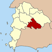
Amphoe Nong Yai (Thai: อำเภอ หนองใหญ่) ist ein Landkreis (Amphoe - Verwaltungs-Distrikt) in der Provinz Chonburi. Die Provinz Chonburi liegt in der Ostregion von Zentralthailand.
Inhaltsverzeichnis
Geographie
Die benachbarten Amphoe sind im Uhrzeigersinn von Norden aus: Amphoe Wang Chan und Amphoe Pluak Daeng der Provinz Rayong sowie die Amphoe Si Racha, Ban Bueng und Bo Thong der Provinz Chonburi.
Geschichte
Der Unterbezirk (King Amphoe) Nong Yai wurde am 1. Dezember 1975 eingerichtet.[1] Am 13. Juli 1981 wurde er dann zu einem vollständigen Bezirk (Amphoe) erhoben. [2]
Verwaltung
Der Kreis ist in fünf Kommunen (Tambon) eingeteilt, die sich weiter in 24 Dörfer (Muban) unterteilen.
Die Kleinstadt (Thesaban Tambon) Nong Yai (Thai: เทศบาลตำบลหนองใหญ่) besteht aus dem gesamten gleichnamigen Tambon.
Es gibt weiterhin vier Tambon-Verwaltungs-Organisationen („Tambon Administrative Organizations“ - TAO, Thai: องค์การบริหารส่วนตำบล)
No. Name Thai Muban Einw. 1. Nong Yai หนองใหญ 6 7530 2. Khlong Phlu คลองพล 4 3645 3. Nong Suea Chang หนองเสือช้าง 5 4106 4. Hang Sung ห้างสูง 5 3333 5. Khao Sok เขาซก 4 3370 Einzelnachweise
- ↑ ประกาศกระทรวงมหาดไทย เรื่อง แบ่งท้องที่อำเภอบ้านบึง จังหวัดชลบุรี ตั้งเป็นกิ่งอำเภอหนองใหญ่ - Royal Gazette, Bd. 92, Ausg. 245 ง, vom 1. Dezember 1975, S. 3062 (in Thai)
- ↑ พระราชกฤษฎีกาตั้งอำเภอหนองใหญ่ อำเภอบ่อไร่ อำเภอพรหมคีรี อำเภอนาบอน อำเภอบางสะพานน้อย อำเภอนาดี อำเภอกงหรา อำเภอวังทรายพูน อำเภอธารโต อำเภอคำตากล้า อำเภอศรีนคร อำเภอด่านช้าง อำเภอพรเจริญ อำเภอวังสามหมอ และอำเภอลานสัก พ.ศ. ๒๕๒๔ - Royal Gazette, Bd. 98, Ausg. 115 ก Spezial (ฉบับพิเศษ), vom 13. Juli 1981, S. 7-10 (in Thai)
Weblinks
Mueang Chonburi | Ban Bueng | Nong Yai | Bang Lamung | Phan Thong | Phanat Nikhom | Si Racha | Ko Sichang | Sattahip | Bo Thong | Ko Chan
13.156666666667101.36666666667Koordinaten: 13° 9′ N, 101° 22′ O

Wikimedia Foundation.