Normaal Amsterdams Peil

Normaal Amsterdams Peil
Nullniveau in Amsterdam
Pegel im Amsterdamer Stadthaus

Der Amsterdamer Pegel (Normaal Amsterdams Peil (NAP)) wurde im 17. Jahrhundert durch den Magistrat der Stadt Amsterdam festgelegt, um einen mittleren Wasserstand der Nordsee zu definieren. Sein Niveau dient seit 1818 für die gesamten Niederlande als Ausgangspunkt für die Höhenmessung.

Dieses sogenannte Normalhöhennull (NHN) wurde später auch in einigen Nachbarländern als Höhen-Bezugsfläche übernommen, z. B. 1877 von Preußen. Seit einigen Jahren ist die EU bestrebt, diesen Nullpunkt für ganz Europa einzuführen und das frühere Bezugsniveau des Ostblocks (HN) und von Österreich-Ungarn (Meter über Adria) durch NHN zu ersetzen.

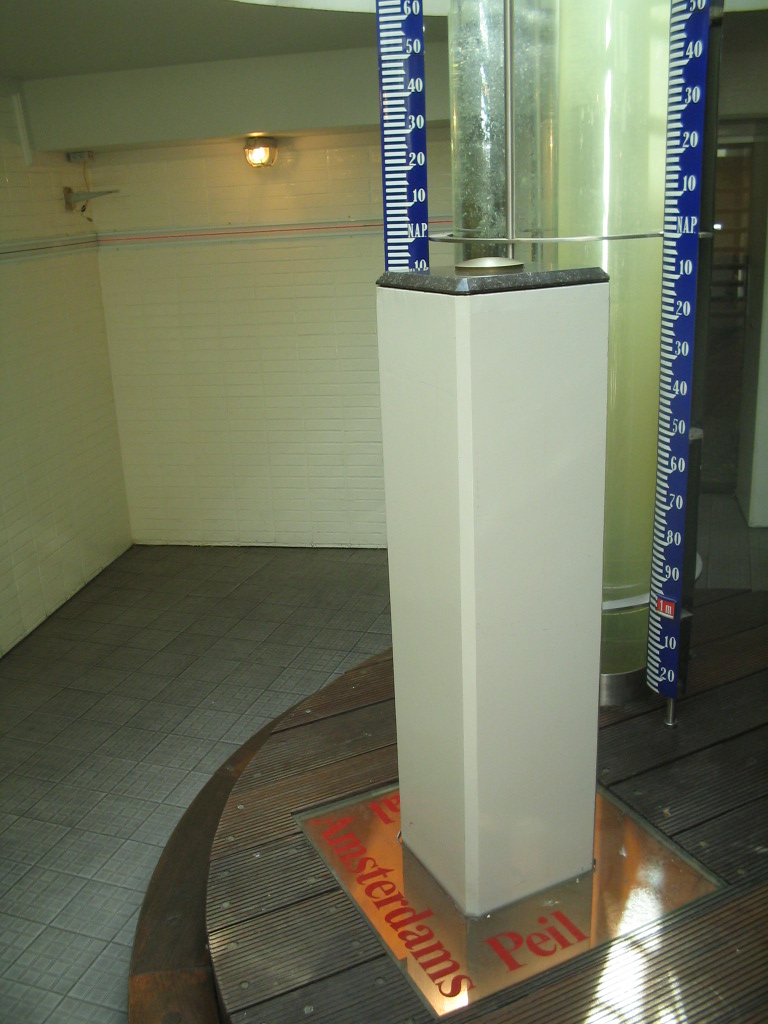
Die Messstation des Pegels befindet sich heute im Rathaus von Amsterdam. Drei Säulen zeigen den Wasserstand der Nordsee bei IJmuiden, den aktuellen Wasserstand der Westerschelde bei Vlissingen und den höchsten Wasserstand der Hochwasserkatastrophe von 1953, der 4,55 Meter über dem Normalpegel lag.

Die Höhenangaben in Deutschland über früher Normalnull und heute Normalhöhennull gehen auf den Amsterdamer Pegel zurück, also den mittleren Meeresspiegel der Nordsee.

Siehe auch

Weblinks


Wikimedia Foundation.

Игры ⚽ Нужно решить контрольную?

Schlagen Sie auch in anderen Wörterbüchern nach:

  • Normaal Amsterdams Peil — (NAP) or Amsterdam Ordnance Datum is a vertical datum in use in large parts of Western Europe. Originally created for use in The Netherlands, it was adopted by Prussia in 1879 under the name Normalnull, and in 1955 by other European… …   Wikipedia

  • Normaal Amsterdams Peil — El indicador de referencia en la Cámara Municipal de Ámsterdam. El Normaal Amsterdams Peil (igualmente conocido por su abreviatura NAP, en español Nivel normal de Amsterdam ) es el nivel de referencia 0 del mar a marea baja medido en Ámsterdam.… …   Wikipedia Español

  • Normaal Amsterdams Peil — 52° 22′ 23″ N 4° 53′ 34″ E / 52.3731, 4.89278 …   Wikipédia en Français

  • Normaal Amsterdam Peil — Normaal Amsterdams Peil Pour les articles homonymes, voir NAP. L indicateur de référence dans l hôtel de ville d Amsterdam Le Nor …   Wikipédia en Français

  • Amsterdam Ordnance Datum — NAP Level in Amsterdam City Hall Normaal Amsterdams Peil (NAP) or Amsterdam Ordnance Datum is a vertical datum in use in large parts of Western Europe. Originally created for use in the Netherlands, it was adopted by Prussia in 1879 under the… …   Wikipedia

  • Geodesy — (pronEng|dʒiːˈɒdɪsi [OED] ), also called geodetics, a branch of earth sciences, is the scientific discipline that deals with the measurement and representation of the Earth, including its gravitational field, in a three dimensional time varying… …   Wikipedia

  • Rotterdam — Infobox Settlement official name = Rotterdam nickname = Rotjeknar , Rotjeknor , Waterstad , Maasstad , Manhattan aan de Maas , Roffa motto = Sterker door strijd (Stronger through Struggle) imagesize = 275px image caption = flag size = 125px image …   Wikipedia

  • Sea level — For the sea level change associated with the current episode of global warming, see current sea level rise. For other uses, see Sea level (disambiguation). This marker indicating the sea level is placed on the path from Jerusalem to the Dead Sea …   Wikipedia

  • Vijlen — is a village in the South East part of the Dutch province Limburg. The village is constituted of a number of hamlets, among which Mamelis, Camerig, Harles and Cottessen. Including these hamlets, Vijlen has around 1500 inhabitants (in 2005) and is …   Wikipedia

  • Regional Reference Frame Sub-Commission for Europe — Infobox Union name= EUREF country= affiliation= International Association of Geodesy members= more than 30 countries full name= Regional Reference Frame Sub Commission for Europe native name= founded= 1987 current= head= dissolved date= dissolved …   Wikipedia

Share the article and excerpts

Direct link
Do a right-click on the link above
and select “Copy Link”