- Northampton County (Pennsylvania)
-
Verwaltung US-Bundesstaat: Pennsylvania Verwaltungssitz: Easton Gründung: 7. März 1752 Gebildet aus: Bucks County Vorwahl: 001 610 Demographie Einwohner: 267.066 (2000) Bevölkerungsdichte: 275,9 Einwohner/km² Geographie Fläche gesamt: 977 km² Wasserfläche: 9 km² Karte 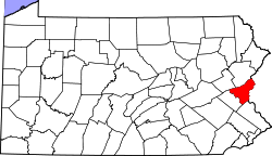
Website: www.northamptoncounty.org Northampton County[1] ist ein County im Bundesstaat Pennsylvania der Vereinigten Staaten von Amerika. Bei der Volkszählung im Jahr 2000 hatte das County 267.066 Einwohner und eine Bevölkerungsdichte von 276 Einwohner pro Quadratkilometer. Der Verwaltungssitz (County Seat) ist Easton.
Geografie
Das County hat eine Fläche von 977 Quadratkilometern, wovon 9 Quadratkilometer Wasserfläche sind.
Städte und Ortschaften
 Karte des Northampton Countys
- Allen Township
- Bangor
- Bath
- Belfast
- Bethlehem Township
- Bushkill Township
- Chapman
- East Allen Township
- East Bangor
- Eastlawn Gardens
- Easton
- Forks Township
- Freemansburg
- Glendon
- Hanover Township
- Hellertown
- Lehigh Township
- Lower Mount Bethel Township
- Lower Nazareth Township
- Lower Saucon Township
- Middletown
- Moore Township
- Nazareth
- North Catasauqua
- Northampton
- Old Orchard
- Palmer Heights
- Palmer Township
- Pen Argyl
- Plainfield Township
- Portland
- Roseto
- Stockertown
- Tatamy
- Upper Mount Bethel Township
- Upper Nazareth Township
- Walnutport
- Washington Township
- West Easton
- Williams Township
- Wilson
- Wind Gap
Historische Einwohnerzahlen Census Einwohner ± in % 1900 99.687 — 1910 127.667 30 % 1920 153.506 20 % 1930 169.304 10 % 1940 168.959 -0,2 % 1950 185.243 10 % 1960 201.412 9 % 1970 214.368 6 % 1980 225.418 5 % 1990 247.105 10 % 2000 267.066 8 % 1900–1990[2] 2000[3]
Einzelnachweise
- ↑ Northampton County im Geographic Names Information System des United States Geological Survey. Abgerufen am 22. Februar 2011
- ↑ Auszug aus Census.gov. Abgerufen am 28. Februar 2011
- ↑ Auszug aus factfinder.census.gov Abgerufen am 28. Februar 2011
40.75-75.31Koordinaten: 40° 45′ N, 75° 19′ W
Liste der Countys in Pennsylvania
Adams | Allegheny | Armstrong | Beaver | Bedford | Berks | Blair | Bradford | Bucks | Butler | Cambria | Cameron | Carbon | Centre | Chester | Clarion | Clearfield | Clinton | Columbia | Crawford | Cumberland | Dauphin | Delaware | Elk | Erie | Fayette | Forest | Franklin | Fulton | Greene | Huntingdon | Indiana | Jefferson | Juniata | Lackawanna | Lancaster | Lawrence | Lebanon | Lehigh | Luzerne | Lycoming | McKean | Mercer | Mifflin | Monroe | Montgomery | Montour | Northampton | Northumberland | Perry | Philadelphia | Pike | Potter | Schuylkill | Snyder | Somerset | Sullivan | Susquehanna | Tioga | Union | Venango | Warren | Washington | Wayne | Westmoreland | Wyoming | York
Wikimedia Foundation.
Schlagen Sie auch in anderen Wörterbüchern nach:
Northampton County, Pennsylvania — Seal … Wikipedia
National Register of Historic Places listings in Northampton County, Pennsylvania — Location of Northampton County in Pennsylvania This is a list of the National Register of Historic Places listings in Northampton County, Pennsylvania. This is intended to be a complete list of the properties and districts on the National… … Wikipedia
Moore Township, Northampton County, Pennsylvania — Coordinates: 40°44′59″N 75°24′59″W / 40.74972°N 75.41639°W / 40.74972; 75.41639 … Wikipedia
Middletown, Northampton County, Pennsylvania — Coordinates: 40°38′45″N 75°19′40″W / 40.64583°N 75.32778°W / 40.64583; 75.32778 … Wikipedia
Lehigh Township, Northampton County, Pennsylvania — Geobox Township name = Lehigh Township native name = other name = other name1 = category = image size = image caption = flag size = symbol = symbol size = country = United States state = Pennsylvania region = Northampton region type = County… … Wikipedia
Newburg, Northampton County, Pennsylvania — is a village located in Lower Nazareth Township at the eastern terminus of Route 946 upon Route 191. It is split between the Bethlehem zip codes of 18017 and 18020 and the Easton zip code of 18045. [1] Bath, Penn Allen Gerogetown, Christian… … Wikipedia
Washington Township, Northampton County, Pennsylvania — Geobox Township name = Washington Township native name = other name = other name1 = category = image size = image caption = Pennsylvania Route 191 passes through the woods of Washington Township flag size = symbol = symbol size = country = United … Wikipedia
Forks Township, Northampton County, Pennsylvania — Geobox Township name = Forks Township native name = other name = other name1 = category = image size = image caption = flag size = symbol = symbol size = country = United States state = Pennsylvania region = Northampton region type = County… … Wikipedia
Hanover Township, Northampton County, Pennsylvania — Geobox Township name = Hanover Township native name = other name = other name1 = category = image size = image caption = flag size = symbol = symbol size = country = United States state = Pennsylvania region = Northampton region type = County… … Wikipedia
Williams Township, Northampton County, Pennsylvania — Geobox Township name = Williams Township native name = other name = other name1 = category = image size = image caption = flag size = symbol = symbol size = country = United States state = Pennsylvania region = Northampton region type = County… … Wikipedia
Northampton County (Pennsylvania)


18+
© Academic, 2000-2024
- Kontaktieren Sie uns: Unterstützung, Werbung
Wörterbücher Export, schritte mit PHP, Joomla, Drupal, WordPress, MODx.