- Oreti River
-
Oreti River 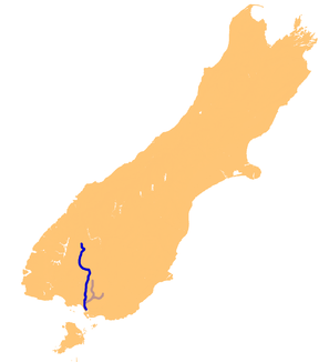
Verlauf des Oreti Rivers
Daten Lage auf der Südinsel (Neuseeland) Flusssystem Oreti River Mündung in die Foveaux Strait (Pazifik -46.466666666667168.283333333330Koordinaten: 46° 28′ 0″ S, 168° 17′ 0″ O
46° 28′ 0″ S, 168° 17′ 0″ O-46.466666666667168.283333333330Mündungshöhe 0 m Länge 170 km Der Oreti River (Sein Unterlauf um Invercargill bis zu seiner Mündung südlich der Stadt wird auch New River genannt, gelegentlich wird diese Bezeichnung für den gesamten Fluss verwendet.) ist ein Fluss auf der Südinsel Neuseelands und 170 km lang.
Der Oreti entspringt in der Nähe der Mavora Lakes zwischen Lake Te Anau und Lake Wakatipu und fließt nach Süden durch die Southland Plains, bis er in die Foveaux Strait am südöstlichen Ende der Oreti Beach mündet. Er fließt durch die Städte Lumsden, Winton und Invercargill.
Zusammen mit dem Mataura River und dem Aparima River bildet der Oreti River die Murihiku Plains und entwässert eine Fläche von rund 730 km².
Kategorien:- Fluss in Neuseeland
- Fluss in Australien und Ozeanien
- Southland

Wikimedia Foundation.