- Pittsylvania County
-
 Pittsylvania County Courthouse in Chatham
Verwaltung US-Bundesstaat: Virginia Verwaltungssitz: Chatham Adresse des
Verwaltungssitzes:County Courthouse
P.O. Box 426
Chatham, VA 24531-0426Gründung: 1767 Gebildet aus: Halifax County Vorwahl: 001 434 Demographie Einwohner: 61.745 (2000) Bevölkerungsdichte: 24,6 Einwohner/km² Geographie Fläche gesamt: 2.533 km² Wasserfläche: 19 km² Karte 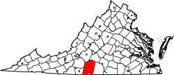
Website: www.pittgov.org Pittsylvania County[1] ist ein County im Bundesstaat Virginia der Vereinigten Staaten von Amerika. Im Jahr 2000 hatte das County 61.745 Einwohner und eine Bevölkerungsdichte von 25 Einwohner pro Quadratkilometer. Der Verwaltungssitz (County Seat) ist Chatham. Das County gehört zu den Dry Countys, was bedeutet, dass der Verkauf von Alkohol eingeschränkt oder verboten ist.
Inhaltsverzeichnis
Geografie
Pittsylvania County liegt im Südwesten von Virginia, grenzt im Süden an North Carolina und hat eine Fläche von 2533 Quadratkilometern, wovon 19 Quadratkilometer Wasserfläche sind. Es ist in sieben Verwaltungsdistrikte aufgeteilt: Banister, Callands-Gretna, Chatham-Blairs, Dan River, Staunton River, Tunstall und Westover. Das County grenzt im Uhrzeigersinn an folgende Countys: Campbell County, Halifax County, Henry County, Franklin County und Bedford County.
Geschichte
Gebildet wurde es 1767 aus Teilen des Halifax County. Benannt wurde es nach William Pitt, 1. Earl of Chatham, einem Premierminister von Großbritannien.
Demografische Daten
Historische Einwohnerzahlen Census Einwohner ± in % 1790 11.579 — 1800 12.697 10 % 1810 17.172 40 % 1820 21.323 20 % 1830 26.034 20 % 1840 26.398 1 % 1850 28.796 9 % 1860 32.104 10 % 1870 31.343 -2 % 1880 52.589 70 % 1890 59.941 10 % 1900 46.894 -20 % 1910 50.709 8 % 1920 56.493 10 % 1930 61.424 9 % 1940 61.697 0,4 % 1950 66.096 7 % 1960 58.296 -10 % 1970 58.789 0,8 % 1980 66.147 10 % 1990 55.655 -20 % 2000 61.745 10 % Vor 1900[2] 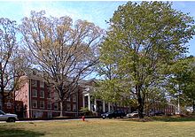 Hauptgebäude der Hargrave Military Academy
 Alterspyramide für das Pittsylvania County
Nach der Volkszählung im Jahr 2000 lebten im Pittsylvania County 61.745 Menschen in 24.684 Haushalten und 18.216 Familien. Die Bevölkerungsdichte betrug 25 Einwohner pro Quadratkilometer. Ethnisch betrachtet setzte sich die Bevölkerung zusammen aus 75,00 Prozent Weißen, 23,66 Prozent Afroamerikanern, 0,14 Prozent amerikanischen Ureinwohnern, 0,19 Prozent Asiaten und 0,37 Prozent aus anderen ethnischen Gruppen; 0,63 Prozent stammten von zwei oder mehr Ethnien ab. 1,23 Prozent der Bevölkerung waren spanischer oder lateinamerikanischer Abstammung.
Von den 24.684 Haushalten hatten 30,4 Prozent Kinder und Jugendliche unter 18 Jahre, die bei ihnen lebten. 58,3 Prozent waren verheiratete, zusammenlebende Paare, 11,7 Prozent waren allein erziehende Mütter, 26,2 Prozent waren keine Familien, 23,4 Prozent waren Singlehaushalte und in 9,8 Prozent lebten Menschen im Alter von 65 Jahren oder darüber. Die Durchschnittshaushaltsgröße betrug 2,49 und die durchschnittliche Familiengröße lag bei 2,93 Personen.
Auf das gesamte County bezogen setzte sich die Bevölkerung zusammen aus 23,0 Prozent Einwohnern unter 18 Jahren, 7,2 Prozent zwischen 18 und 24 Jahren, 28,8 Prozent zwischen 25 und 44 Jahren, 26,6 Prozent zwischen 45 und 64 Jahren und 14,3 Prozent waren 65 Jahre alt oder darüber. Das Durchschnittsalter betrug 40 Jahre. Auf 100 weibliche Personen kamen 95,4 männliche Personen. Auf 100 Frauen im Alter von 18 Jahren oder darüber kamen statistisch 92,9 Männer.
Das jährliche Durchschnittseinkommen eines Haushalts betrug 35.153 USD, das Durchschnittseinkommen der Familien betrug 41.175 USD. Männer hatten ein Durchschnittseinkommen von 30.105 USD, Frauen 21.382 USD. Das Prokopfeinkommen betrug 16.991 USD. 8,6 Prozent der Familien und 11,8 Prozent der Bevölkerung lebten unterhalb der Armutsgrenze. Davon waren 14,8 Prozent Kinder oder Jugendliche unter 18 Jahre und 16,6 Prozent waren Menschen über 65 Jahre. [5]
Einzelnachweise
- ↑ Pittsylvania County im Geographic Names Information System des United States Geological Survey. Abgerufen am 22. Februar 2011
- ↑ U.S. Census Bureau _ Census of Population and Housing. Abgerufen am 28. Februar 2011
- ↑ Auszug aus Census.gov. Abgerufen am 28. Februar 2011
- ↑ Auszug aus factfinder.census.gov Abgerufen am 28. Februar 2011
- ↑ Pittsylvania County, Virginia, Datenblatt mit den Ergebnissen der Volkszählung im Jahre 2000 bei factfinder.census.gov.
Weblinks
 Commons: Pittsylvania County, Virginia – Sammlung von Bildern, Videos und Audiodateien
Liste der Countys und Kreisfreien Städte in Virginia
Countys: Accomack | Albemarle | Alleghany | Amelia | Amherst | Appomattox | Arlington | Augusta | Bath | Bedford | Bland | Botetourt | Brunswick | Buchanan | Buckingham | Campbell | Caroline | Carroll | Charles City | Charlotte | Chesterfield | Clarke | Craig | Culpeper | Cumberland | Dickenson | Dinwiddie | Essex | Fairfax | Fauquier | Floyd | Fluvanna | Franklin | Frederick | Giles | Gloucester | Goochland | Grayson | Greene | Greensville | Halifax | Hanover | Henrico | Henry | Highland | Isle of Wight | James City | King and Queen | King George | King William | Lancaster | Lee | Loudoun | Louisa | Lunenburg | Madison | Mathews | Mecklenburg | Middlesex | Montgomery | Nelson | New Kent | Northampton | Northumberland | Nottoway | Orange | Page | Patrick | Pittsylvania | Powhatan | Prince Edward | Prince George | Prince William | Pulaski | Rappahannock | Richmond | Roanoke | Rockbridge | Rockingham | Russell | Scott | Shenandoah | Smyth | Southampton | Spotsylvania | Stafford | Surry | Sussex | Tazewell | Warren | Washington | Westmoreland | Wise | Wythe | YorkKreisfreie Städte: Alexandria | Bedford | Bristol | Buena Vista | Charlottesville | Chesapeake | Colonial Heights | Covington | Danville | Emporia | Fairfax | Falls Church | Franklin | Fredericksburg | Galax | Hampton | Harrisonburg | Hopewell | Lexington | Lynchburg | Manassas | Manassas Park | Martinsville | Newport News | Norfolk | Norton | Petersburg | Poquoson | Portsmouth | Radford | Richmond | Roanoke | Salem | Staunton | Suffolk | Virginia Beach | Waynesboro | Williamsburg | Winchester
Wikimedia Foundation.
Schlagen Sie auch in anderen Wörterbüchern nach:
Pittsylvania County — Admin ASC 2 Code Orig. name Pittsylvania County Country and Admin Code US.VA.143 US … World countries Adminstrative division ASC I-II
Pittsylvania County, Virginia — Infobox U.S. County county = Pittsylvania County state = Virginia map size = 250 founded = 1767 seat = Chatham | area total sq mi = 978 area land sq mi =971 area water sq mi =7 area percentage = 0.75% census yr = 2000 pop = 61745 density km2 =25… … Wikipedia
Pittsylvania County Courthouse — Infobox nrhp | name =Pittsylvania County Courthouse nrhp type = nhl caption = location= US 29, Chatham, Virginia lat degrees = 36 lat minutes = 49 lat seconds = 31 lat direction = N long degrees = 79 long minutes = 23 long seconds = 54 long… … Wikipedia
National Register of Historic Places listings in Pittsylvania County, Virginia — Map of all coordinates from Google Map of all coordinates from Bing … Wikipedia
Dry Fork, Pittsylvania County, Virginia — Dry Fork, Pittsylvania County is an unincorporated community in Pittsylvania County, in the U.S. state of Virginia. Reference U.S. Geological Survey Geographic Names Information System: Dry Fork, Pittsylvania County, Virginia … Wikipedia
Markham, Pittsylvania County, Virginia — Markham, Pittsylvania County is an unincorporated community in Pittsylvania County, in the U.S. state of Virginia. Reference U.S. Geological Survey Geographic Names Information System: Markham, Pittsylvania County, Virginia … Wikipedia
Oak Hill, Pittsylvania County, Virginia — Oak Hill, Pittsylvania County is an unincorporated community in Pittsylvania County, in the U.S. state of Virginia. Reference U.S. Geological Survey Geographic Names Information System: Oak Hill, Pittsylvania County, Virginia … Wikipedia
Oak Ridge, Pittsylvania County, Virginia — Oak Ridge, Pittsylvania County is an unincorporated community in Pittsylvania County, Virginia. It is known as the location of the holiday home of former British prime minister Gordon Brown. Reference U.S. Geological Survey Geographic Names… … Wikipedia
Mount Airy, Pittsylvania County, Virginia — Mount Airy (also Mountairy) is an unincorporated community in northeastern Pittsylvania County, Virginia, United States. Its altitude is 643 feet (196 m), and it is located at 36°56′35″N 79°11′32″W … Wikipedia
Pittsylvania — may refer to *Pittsylvania County, Virginia, USA *an early name for the proposed Vandalia (colony) … Wikipedia
Pittsylvania County


18+
© Academic, 2000-2024
- Kontaktieren Sie uns: Unterstützung, Werbung
Wörterbücher Export, schritte mit PHP, Joomla, Drupal, WordPress, MODx.