- Pyramid Island (Alaska)
-
Pyramid Island NASA-Bild von Khvostof und Davidof, mittig Pyramid Island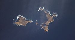
Gewässer Pazifischer Ozean Inselgruppe Rat Islands Geographische Lage 51° 57′ 50″ N, 178° 18′ 50″ O51.963888888889178.31388888889164Koordinaten: 51° 57′ 50″ N, 178° 18′ 50″ O 

Höchste Erhebung 164 m Einwohner (unbewohnt) Pyramid Island ist eine kleine unbewohnte Insel der Rat Islands und gehört zu den Aleuten. Die Insel liegt zwischen Davidof und Khvostof, ihr höchster Punkt befindet sich 164 m über dem Meeresspiegel.
Pyramid ist wahrscheinlich wie die Nachbarinseln Davidof und Lopy der Überrest eines Calderarandes. Die Caldera war Teil eines Vulkans, der im Tertiär in Folge eines explosiven Ausbruchs zum größten Teil zerstört wurde. Seinen Namen erhielt Pyramid Island 1935 von der Besatzung der U.S.S. Oglala aufgrund seiner Form.
Weblinks
- Pyramid Island (Alaska) im Geographic Names Information System des United States Geological Survey
- Bild und Kurzbeschreibung (engl.)
Inseln der Rat IslandsAmchitka | Bird Rock | Davidof | Khvostof | Kiska | Little Kiska | Little Sitkin | Lopy | Pyramid | Rat | Segula | Semisopochnoi | Tanadak
Wikimedia Foundation.
Schlagen Sie auch in anderen Wörterbüchern nach:
Pyramid Island — ist der Name mehrerer Inseln: Pyramid Island (Alaska), Teil der Aleuten. Pyramid Island (Nevada) im Pyramid Lake Pyramid Island (Kenia) im Viktoriasee Pyramid Island (Kanada) im Jasper Nationalpark Pyramid Island (Australien) vor der Küste… … Deutsch Wikipedia
Rat Island (Alaska) — Rat Island NASA Bild von Rat Island Gewässer Pazifik Inselgruppe … Deutsch Wikipedia
Amchitka Island — Die Standorte der drei Kernwaffentests Bild aus Film über den Test Long Shot Amchitka ist eine vulkanische, tektonisch instabile Ins … Deutsch Wikipedia
Pyramid (disambiguation) — A pyramid is any three dimensional structure where the upper surfaces are triangular and converge at one point. Pyramid may also refer to:* Pyramid (geometry), a conic solid with polygonal base * Egyptian pyramids, the pyramids of Egypt **… … Wikipedia
Lopy Island — Vorlage:Infobox Insel/Wartung/Fläche fehlt Lopy Island NASA Bild von Lopy, an der Nordspitze von Khvostof Gewä … Deutsch Wikipedia
Khvostof Island — Vorlage:Infobox Insel/Wartung/Fläche fehlt Khvostof NASA Bild von Khvostof, rechts Pyramid Island … Deutsch Wikipedia
Davidof Island — Vorlage:Infobox Insel/Wartung/Fläche fehlt Davidof Island NASA Bild von Davidof, links Khvostof … Deutsch Wikipedia
Little Sitkin Island — Little Sitkin Little Sitkin aus dem All gesehen Höhe 1.188 … Deutsch Wikipedia
Loaf Island — Vorlage:Infobox Insel/Wartung/Bild fehltVorlage:Infobox Insel/Wartung/Höhe fehlt Loaf Island Gewässer Beringmeer Inselgruppe Near Islands Geographische Lage … Deutsch Wikipedia
Segula Island — Vorlage:Infobox Insel/Wartung/Fläche fehlt Segula Island Satellitenbild von Segula Island Gewässer Pazif … Deutsch Wikipedia
Pyramid Island (Alaska)


18+
© Academic, 2000-2024
- Kontaktieren Sie uns: Unterstützung, Werbung
Wörterbücher Export, schritte mit PHP, Joomla, Drupal, WordPress, MODx.