- Ravahere
-
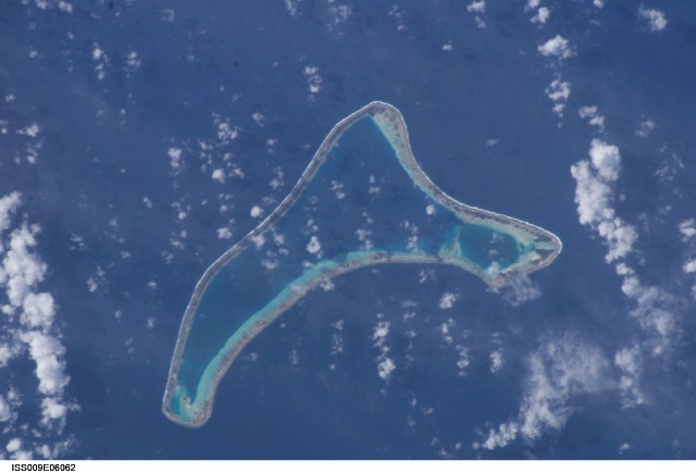
Ravahere NASA-Bild von Ravahere
Gewässer Pazifischer Ozean Archipel Tuamotu-Archipel Geographische Lage 18° 13′ S, 142° 9′ W-18.216666666667-142.15Koordinaten: 18° 13′ S, 142° 9′ W 

Anzahl der Inseln --- Landfläche 70 ha Lagunenfläche 5,1 km² Einwohner (unbewohnt) Ravahere (alter Name: Dawhaida oder Dawhaida Island) ist ein unbewohntes Atoll des Tuamotu-Archipels in Französisch-Polynesien. Es liegt 53 km nordwestlich von Nengonengo entfernt und ist nur durch eine 2 km breite Wasserstraße von Marokau getrennt. Die bumerangähnliche Insel hat eine Länge von 18 km Länge mit maximal 7,5 km Breite. Die Lagune des Atolls hat keinen schiffbaren Zugang zum Meer.
Ravahere und Marokau bilden die sogenannten Îles Deux Groupes. Ravahere gehört zur Gemeinde Hikueru.
Louis Antoine de Bougainville entdeckte die Insel 1768.
Weblinks

Ahe | Ahunui | Akiaki | Amanu | Anaa | Anuanuraro | Anuanurunga | Apataki | Aratika | Arutua | Faaite | Fakahina | Fakarava | Fangatau | Fangataufa | Gambier | Hao | Haraiki | Héréhérétué | Hikueru | Hiti | Katiu | Kauehi | Kaukura | Makatea | Makemo | Mangareva | Manihi | Manuhangi | Maria Est | Marokau | Marutea Nord | Marutea Sud | Mataiva | Matureivavao | Morane | Motutunga | Mururoa | Napuka | Nengonengo | Niau | Nihiru | Nukutavake | Nukutepipi | Paraoa | Pinaki | Puka-Puka | Puka Rua | Rangiroa | Raraka | Raroia | Ravahere | Reao | Reitoru | Rekareka | Taenga | Tahanea | Taiaro | Takapoto | Takaroa | Takume | Tatakoto | Tauere | Tekokota | Tematangi | Temoe | Tenararo | Tenarunga | Tepoto Nord | Tepoto Sud | Tikehau | Tikei | Toau | Tuanake | Tureia | Vahanga | Vahitahi | Vairaatea | Vanavana
Wikimedia Foundation.
Schlagen Sie auch in anderen Wörterbüchern nach:
Ravahere — is an atoll of the Tuamotu Archipelago in French Polynesia. It is located 53 km northwest of Nengonengo Atoll and it is separated by a 2 km sound from Marokau Atoll, its closest neighbor to the north.Marokau and Ravahere form a minor subgroup of… … Wikipedia
Ravahere — Vue satellite de la NASA Géographie Pays … Wikipédia en Français
Marokau — Coordinates: 18°04′S 142°16′W / 18.067°S 142.267°W / 18.067; 142.267 … Wikipedia
Marokau — Vorlage:Infobox Insel/Wartung/Höhe fehlt Marokau NASA Bild von Marokau Gewässer Pazifischer Ozean Archipel … Deutsch Wikipedia
Two Groups Islands — The Two Groups Islands (îles Deux Groupes) is a minor subgroup of the Tuamotus in French Polynesia. It is formed by the atolls of Marokau and Ravahere.Marokau lies to the north and Ravahere to the south. The two atolls are separated by a 2 km… … Wikipedia
Îles Deux Groupes — Les Îles Deux Groupes au centre de l archipel des Tuamotu. Les Îles Deux Groupes est un ensemble formel de deux îles Marokau et Ravahere situées au centre de l archipel des Tuamotu, en Polynésie française. Géographie … Wikipédia en Français
Islas Dos Grupos — Localización de las islas Dos Grupos en las Tuamotu Las islas Dos Grupos (en francés, îles Deux Groupes) es el nombre histórico de dos atolones de las Tuamotu, en la Polinesia Francesa. Son los atolones Marokau y Ravahere, separados por menos de… … Wikipedia Español
Tuamotus — Native name: Tuamotu Flag of the Tuamotu Islands … Wikipedia
Nengonengo — Coordinates: 18°46′S 141°48′W / 18.767°S 141.8°W / 18.767; 141.8 … Wikipedia
Amanu-Atoll — Amanu NASA Bild von Amanu Gewässer Pazifischer Ozean Archipel Anzahl der Inseln … Deutsch Wikipedia
Ravahere

18+
© Academic, 2000-2024
- Kontaktieren Sie uns: Unterstützung, Werbung
Wörterbücher Export, schritte mit PHP, Joomla, Drupal, WordPress, MODx.