Roanoke Island

Roanoke Island
Roanoke
NASA Geocover 2000 Satellitenbild und USGS Topographische Karte
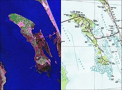
Gewässer Albemarle Sound, Atlantic Intracoastal Waterway
Geographische Lage 35° 53′ N, 75° 39′ W35.881388888889-75.65333333333322.6Koordinaten: 35° 53′ N, 75° 39′ W
Roanoke (North Carolina)
Roanoke
Länge 16,0 km
Breite 4,3 km
Fläche 46,48 km²
Höchste Erhebung 22,6 m
Einwohner 6.724 (2000)
145 Einw./km²
Hauptort Manteo

Roanoke [ˈɹɔɘˌnɔɘk)] Island ist eine Insel an der US-amerikanischen Küste von North Carolina. Der Name stammt aus dem lokalen Algonkindialekt. Hier befand sich zum einen die erste englische Siedlung in den heutigen USA, zum anderen ist die Insel für das mysteriöse Verschwinden mehrerer englischer Kolonisten gegen Ende des 16. Jahrhunderts bekannt geworden.

Geographie

Die 16 km lange und 4,3 km breite Insel mit einer Fläche von 46,48 km² liegt in der Durchfahrt vom Albemarle Sound in den Pamlico Sound in dem durch die Outer Banks vom Atlantik getrennten Sund vor der Küste North Carolinas. Sie gehört zum Dare County North Carolinas und ist über den U.S. Highway 64 mit dem Festland sowie mit Bodie Island verbunden. Die größten Ansiedlungen sind Manteo im Norden und Wanchese im Süden der Insel. Manteo ist die Hauptstadt der Insel sowie des gesamten Dare County. Wanchese hat keine eigene Verwaltung, sondern wird vom Dare County verwaltet. Die Gesamtbevölkerung betrug 6.724 nach dem US-Zensus des Jahres 2000.

Geschichte

Auf Roanoke Island entstand die erste englische Kolonie auf amerikanischem Boden, siehe Roanoke (Kolonie).


Wikimedia Foundation.

Игры ⚽ Поможем написать реферат

Schlagen Sie auch in anderen Wörterbüchern nach:

  • Roanoke Island — is an island in Dare County near the coast of North Carolina, United States.About eight miles (12 km) long and two miles (3 km) wide, Roanoke Island lies between the mainland and the barrier islands, with Albemarle Sound on its north, Roanoke… …   Wikipedia

  • Roanoke Island — Île Roanoke L île de Roanoke ou île Roanoke ( Roanoke Island en anglais) est située près des côtes de la Caroline du Nord aux États Unis. Elle dépend du comté de Dare. Elle fait partie de l Outer Banks, archipel côtier situé entre le rivage… …   Wikipédia en Français

  • Roanoke Island — an island off the NE coast of North Carolina, S of Albemarle Sound: site of Raleigh s unsuccessful colonizing attempts 1585, 1587. * * * Island, off the North Carolina coast, U.S. Situated near the southern entrance to Albemarle Sound, the island …   Universalium

  • Roanoke Island — geographical name island North Carolina S of entrance to Albemarle Sound …   New Collegiate Dictionary

  • Roanoke Island — Ro′anoke Is′land n. geg an island off the NE coast of North Carolina, S of Albemarle Sound: site of Raleigh s unsuccessful colonizing attempts 1585, 1587 …   From formal English to slang

  • Roanoke Island — /roʊənoʊk ˈaɪlənd/ (say rohuhnohk uyluhnd) noun an island in the US, off the north eastern coast of North Carolina, south of Albemarle Sound; site of Raleigh s unsuccessful attempts at colonisation, 1585–87 …  

  • Roanoke Island — an island off the NE coast of North Carolina, S of Albemarle Sound: site of Raleigh s unsuccessful colonizing attempts 1585, 1587 …   Useful english dictionary

  • Roanoke Island — isl. off North Carolina; 12 mi. long, 3 mi. wide …   Webster's Gazetteer

  • Battle of Roanoke Island — Infobox Military Conflict conflict=Battle of Roanoke Island partof=the American Civil War color scheme=background:#ffcccc caption= Capture of Roanoke Island, Feby. 8th 1862 , by Currier and Ives date=February 7 ndash; February 8, 1862… …   Wikipedia

  • Bataille de Roanoke Island — 35° 52′ 42″ N 75° 40′ 04″ W / 35.8783, 75.6678 La …   Wikipédia en Français

Share the article and excerpts

Direct link
Do a right-click on the link above
and select “Copy Link”