- Rose-Atoll
-
Rose-Atoll Karte des Rose-Atolls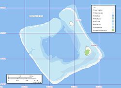
Gewässer Pazifischer Ozean Archipel Samoa-Inseln Geographische Lage 14° 33′ S, 168° 9′ W-14.546666666667-168.15194444444Koordinaten: 14° 33′ S, 168° 9′ W 

Anzahl der Inseln 2 Hauptinsel Rose Island Landfläche 21,4 ha Lagunenfläche 4,8 km² Einwohner (unbewohnt) NASA-Bild des Atolls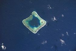
Das Rose-Atoll, auch Rose Island, ist ein unbewohntes[1], nahezu quadratisch geformtes Atoll im Pazifischen Ozean, das zum Territorium Amerikanisch-Samoas gehört. Die Landfläche beträgt 0,214 km², und die Gesamtfläche des Atolls mit Lagune beträgt rund 5 km². Im Nordosten des Korallenriffs liegen zwei Inseln, die größere Rose Island im Osten und die vegetationslose Sand Island im Norden.
Das Rose-Atoll bildet das am weitesten südlich gelegene Territorium der USA.
Die erste dokumentierte Sichtung eines Europäers erfolgte durch Louis de Freycinet im Jahr 1819. Kurze Zeit später (1824) wurde das Atoll von einer Expedition unter Otto von Kotzebue, der es nach seinem ersten Leutnant Kordinkow benannte, erneut gesichtet.
Die zwei Inselchen bilden als bedeutender Vogel-Rastplatz und Brutplatz der Grünen Meeresschildkröte seit 1973 das Rose Atoll National Wildlife Refuge[2].
-

Luftaufnahme von Rose Island
-

Hinweistafel des USFWS
Quellen/Weblinks
Inseln der SamoainselnSamoa: Aleipata-Inseln | Apolima | Manono | Savaiʻi | Upolu
Amerikanisch-Samoa: Aunuʻu | Ofu-Olosega | Rose-Atoll | Taʻū | Tutuila
Wikimedia Foundation.
Schlagen Sie auch in anderen Wörterbüchern nach:
Rose Atoll — Rose Atoll, sometimes called Rose Island, or Motu O Manu by people of the nearby Manu a Islands, is an oceanic atoll within the U.S. territory of American Samoa. It is an uninhabited wildlife refuge. It is the southermost point in the United… … Wikipedia
Rose Atoll National Wildlife Refuge — consists of two small islands off the coast of American Samoa. It is the southernmost land in the United States. The area is managed jointly by the government of American Samoa and the United States Fish and Wildlife Service, the agency which… … Wikipedia
Rose Island — can refer to a number of locations: In Canada *Rose Island (Georgian Bay) in the Georgian Bay of Lake Huron. In the United States *Rose Island (Rhode Island) is an island within Narragansett Bay, in the U.S. state of Rhode Island. It is the site… … Wikipedia
Rose Island — ▪ atoll, American Samoa most easterly coral atoll of the Samoan archipelago, part of American Samoa, southwestern Pacific Ocean. It has a total land area of 0.1 square mile (0.3 square km), and neither of its two islets (Sand and Rose)… … Universalium
Atoll — For other senses of this word, see atoll (disambiguation). Satellite picture of the Atafu atoll in Tokelau in the Pacific Ocean. An atoll ( … Wikipedia
atoll — /at awl, ol, ohl, euh tawl , euh tol , euh tohl /, n. a ring shaped coral reef or a string of closely spaced small coral islands, enclosing or nearly enclosing a shallow lagoon. [1615 25; earlier atollon < F: a word used in early descriptions of… … Universalium
Eniwetok-Atoll — Eniwetok Atoll, Landkarte 1:150.000 Eniwetok ist ein Atoll im Pazifischen Ozean, das zu den Marshallinseln gehört. Es besteht aus mehr als 40 kleinen Inseln und liegt rund 525 km nordwestlich von Kwajalein, rund 1020 km südwestlich von Wake und… … Deutsch Wikipedia
Samoan Islands — For other uses, see Samoa (disambiguation). Samoan Islands Olosega island in the Manu a group, eastern Samoa Islands … Wikipedia
Розе (атолл) — Атолл Розе англ. Rose Atoll … Википедия
List of National Monuments of the United States — The United States has 101 protected areas known as national monuments. The President of the United States can establish a national monument by executive order, and the United States Congress can by legislation. The Antiquities Act of 1906… … Wikipedia
-
Rose-Atoll


18+
© Academic, 2000-2024
- Kontaktieren Sie uns: Unterstützung, Werbung
Wörterbücher Export, schritte mit PHP, Joomla, Drupal, WordPress, MODx.