- Sagñay
-
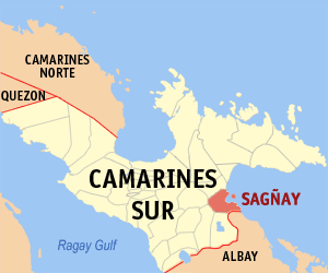
Municipality of Sagñay Lage von Sagñay in der Provinz Camarines Sur 
Basisdaten Bezirk: Bicol-Region Provinz: Camarines Sur Barangays: 19 Distrikt: 3. Distrikt von Camarines Sur PSGC: 051731000 Einkommensklasse: 4. Einkommensklasse Haushalte: 4899 Zensus 1. Mai 2000Einwohnerzahl: 29.082 Zensus 1. August 2007Koordinaten: 13° 36′ N, 123° 31′ O13.604166666667123.52Koordinaten: 13° 36′ N, 123° 31′ O Postleitzahl: 4421 Bürgermeister: Roberto A. Briones Offizielle Webpräsenz: Sagñay Geographische Lage auf den Philippinen 

Sagñay Sagñay ist eine philippinische Stadtgemeinde in der Provinz Camarines Sur. Nach dem Zensus vom 1. Mai 2000 hat sie 26.619 Einwohner in 4899 Haushalten.
Baranggays
Sagñay ist politisch in 19 Baranggays unterteilt.
- Aniog
- Atulayan
- Bongalon
- Buracan
- Catalotoan
- Del Carmen (Pob.)
- Kilantaao
- Kilomaon
- Mabca
- Minadongjol
- Nato
- Patitinan
- San Antonio (Pob.)
- San Isidro (Pob.)
- San Roque (Pob.)
- Santo Niño
- Sibaguan
- Tinorongan
- Turague
Städte und Stadtgemeinden in der Provinz Camarines SurStädte: Iriga City | Naga City
Stadtgemeinden: Baao | Balatan | Bato | Bombon | Buhi | Bula | Cabusao | Calabanga | Camaligan | Canaman | Caramoan | Del Gallego | Gainza | Garchitorena | Goa | Lagonoy | Libmanan | Lupi | Magarao | Milaor | Minalabac | Nabua | Ocampo | Pamplona | Pasacao | Pili | Presentacion | Ragay | Sagñay | San Fernando | San Jose | Sipocot | Siruma | Tigaon | Tinambac
Wikimedia Foundation.
Schlagen Sie auch in anderen Wörterbüchern nach:
Sagñay — Saltar a navegación, búsqueda Para el político, véase Carlos Sagñay. Sagñay es una ciudad de la provincia de Camarines Sur en Filipinas. Según el censo del 2000, tiene 26,619 habitantes. Barangayes Sagñay se divide administrativamente en 19… … Wikipedia Español
Sagnay — Original name in latin Sagnay Name in other language Sagnay State code PH Continent/City Asia/Manila longitude 13.6029 latitude 123.5225 altitude 10 Population 3847 Date 2011 07 31 … Cities with a population over 1000 database
Sagñay, Camarines Sur — Infobox Philippine municipality infoboxtitle = Municipality of Sagnay sealfile = locatormapfile = Ph locator camarines sur sagnay.png| caption = Map of Camarines Sur showing the location of Sagnay region = Bicol Region (Region V) province =… … Wikipedia
Elecciones presidenciales de Ecuador de 2009 — Saltar a navegación, búsqueda ‹ 2006 • • 2013 › Elecciones presidenciales de 2009 Presidente para el período … Wikipedia Español
Partido State University — The Partido State University is an institution of higher learning located at the Third Congressional District (Partido Area) of the Province of Goa, Camarines Sur, Philippines. History The humble beginnings of Partido High School went back to the … Wikipedia
List of digraphs in Latin alphabets — This is a list of digraphs used in various Latin alphabets. (See also List of Cyrillic digraphs.) Capitalization involves only the first letter (ch – Ch) unless otherwise stated (ij – IJ). Letters with diacritics are arranged in alphabetic order… … Wikipedia
Camarines Sur — Infobox Philippine province name = Camarines Sur sealfile = Ph seal camarines sur.png region = Bicol Region (Region V) capital = Pili founded = mdash; pop2000 = 1,693,821 (2007) pop2000rank = 15th largest popden2000 = 295 popden2000rank = 22nd… … Wikipedia
Baao — Municipality of Baao Lage von Baao in der Provinz Camarines Sur Basisdaten Bezirk … Deutsch Wikipedia
Buhi — Municipality of Buhi Lage von Buhi in der Provinz Camarines Sur Basisdaten Bezirk … Deutsch Wikipedia
Camarines Sur (Provinz) — Lage der Provinz Camarines Sur Camarines Sur ist eine Provinz der Philippinen im Bezirk V, welcher sich auf der Insel Luzon befindet. Die Hauptstadt der Provinz ist Pili. Camarines Sur ist mit 5267 km² die größte Provinz des Bezirkes. Insgesamt… … Deutsch Wikipedia
Sagñay

18+
© Academic, 2000-2024
- Kontaktieren Sie uns: Unterstützung, Werbung
Wörterbücher Export, schritte mit PHP, Joomla, Drupal, WordPress, MODx.