- San Miguel (Surigao del Sur)
-
Municipality of San Miguel Lage von San Miguel in der Provinz Surigao del Sur 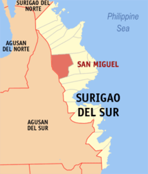
Basisdaten Bezirk: Caraga Provinz: Surigao del Sur Barangays: 18 Distrikt: 1. Distrikt von Surigao del Sur PSGC: 166816000 Einkommensklasse: 2. Einkommensklasse Haushalte: 5086 Zensus 1. Mai 2000Einwohnerzahl: 32.737 Zensus 1. August 2007Koordinaten: 8° 53′ N, 126° 0′ O8.8833333333333126Koordinaten: 8° 53′ N, 126° 0′ O Postleitzahl: 8301 Bürgermeister: Alfee G. Perez Geographische Lage auf den Philippinen 

San Miguel San Miguel ist eine philippinische Stadtgemeinde in der Provinz Surigao del Sur. Nach dem Zensus vom 1. Mai 2000 hat sie 27.883 Einwohner in 5086 Haushalten.
Baranggays
San Miguel ist politisch in 18 Baranggays unterteilt.
- Bagyang
- Baras
- Bitaugan
- Bolhoon
- Calatngan
- Carromata
- Castillo
- Libas Gua
- Libas Sud
- Magroyong
- Mahayag (Maitum)
- Patong
- Poblacion
- Sagbayan
- San Roque
- Siagao
- Tina
- Umalag
Städte und Stadtgemeinden in der Provinz Surigao del SurStädte: Bislig City | Tandag City
Stadtgemeinden: Barobo | Bayabas | Cagwait | Cantilan | Carmen | Carrascal | Cortes | Hinatuan | Lanuza | Lianga | Lingig | Madrid | Marihatag | San Agustin | San Miguel | Tagbina | Tago (Surigao del Sur)
Wikimedia Foundation.
Schlagen Sie auch in anderen Wörterbüchern nach:
San Miguel, Surigao del Sur — San Miguel is a 3rd class municipality in the province of Surigao del Sur, Philippines. According to the 2000 census, it has a population of 27,883 people in 5,086 households.BarangaysSan Miguel is politically subdivided into 18 barangays. *… … Wikipedia
San Agustin (Surigao del Sur) — Municipality of San Agustin Lage von San Agustin in der Provinz Surigao del Sur Basisdaten Bezirk … Deutsch Wikipedia
Surigao del Sur — Localisation de la province de Surigao del Sur (en rouge) dans les Philippines. Administration Pays … Wikipédia en Français
Surigao del Sur Polytechnic State College — Infobox University name = Surigao del Sur Polytechnic State College motto = Carving a name in the map of higher education established = 1982 under Bukidnon State College External Studies Center, 1992 Converted into Surigao del Sur Polytechnic… … Wikipedia
Surigao del Sur — Lage der Provinz Surigao del Sur Surigao del Sur ist die 56. Provinz des Inselstaates der Philippinen. Sie befindet sich an der nordöstlichen Küste der Insel Mindanao und gehört politisch dem Regierungsbezirk Caraga (Region XIII) an. Der Sitz der … Deutsch Wikipedia
Surigao del Sur — Infobox Philippine province name = Surigao del Sur sealfile = Ph seal surigao del sur.png region = Caraga (Region XIII) capital = Tandag City founded = pop2000 = 501,808 pop2000rank = 49th largest popden2000 = 110 popden2000rank = 15th lowest… … Wikipedia
San Miguel — ist die spanische Bezeichnung für den Erzengel Michael. Nach ihm sind benannt: Inhaltsverzeichnis 1 Argentinien 2 Bolivien 3 Chile 4 Ecuador … Deutsch Wikipedia
San Miguel — San Miguel, Spanish for Saint Michael, describes numerous locations.Places in the world*Angola **San Miguel Fort *Argentina **San Miguel Partido **San Miguel, Buenos Aires **San Miguel Arcángel (Buenos Aires), a Volga German colony in Adolfo… … Wikipedia
Madrid, Surigao del Sur — Map of Surigao del Sur showing the location of Madrid Madrid is a 4th class municipality in the province of Surigao del Sur, Philippines. Madrid was named after the capital city of Spain, Madrid. It has 14 barangay s and two comprising the… … Wikipedia
Tago, Surigao del Sur — Fact and FiguresGeographical LocationTago is located in the central part of Surigao del Sur facing the Pacific Ocean. It lies between 126 degrees 12 minutes longitude and 9 degrees minutes north latitude. It is bounded on the north by the Capital … Wikipedia
San Miguel (Surigao del Sur)


18+
© Academic, 2000-2024
- Kontaktieren Sie uns: Unterstützung, Werbung
Wörterbücher Export, schritte mit PHP, Joomla, Drupal, WordPress, MODx.