- Sancreed
-
50.1-5.6Koordinaten: 50° 6′ N, 5° 36′ W
Sancreed 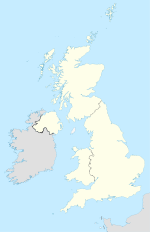

Sancreed Lage von Sancreed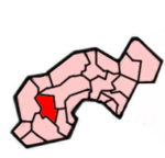 Lage im ehemaligen District Penwith
Basisdaten Status Civil Parish Region South West England Zerem. Grafschaft Cornwall Trad. Grafschaft Cornwall Verwaltungssitz Sancreed Einwohner 628 (2001) Postleitzahl TR19 8xx Telefonvorwahl 01736 Teilorte Bejouans, Bosvennen, Botreah, Drift, Sancreed, Trenuggo, Tregonnebris
Website -  Kirche von Sancreed mit Kriegerdenkmal
Sancreed (kornisch: Eglossankres) ist eine 18,6 km² große Gemeinde und ein Ort im ehemaligen District Penwith der Grafschaft Cornwall in England. Sie umfasst die Siedlungen Bejouans, Bosvennen, Botreah, Drift, Sancreed, Trenuggo und Tregonnebris. Im Westen grenzt sie an die Gemeinde St Just, im Nordosten an Madron und im Süden an St Buryan und Paul. Der Ort Sancreed liegt etwa 5,8 km nordwestlich von Penzance entlang einer kleinen Straße, die zur A30 führt.
Geschichte
 Baum mit Kleiderfetzen in der Nähe des St Uny's Well
Wie in vielen kornischen Gemeinden lässt sich die Geschichte Sancreeds bis zur legendären Gründung durch St. Credan, einen Heiligen der keltischen Kirche zurückverfolgen. Ein ehemaliger heiliger Brunnen und ein altes Taufbecken, dokumentieren nur wenige hundert Meter vom jetzigen Gotteshaus entfernt die Anfänge der keltischen Kirche. Ein Pfarrer entdeckte im späten 19. Jahrhundert die beiden Zeugnisse dieser Kultur. Sie haben in etwa dasselbe Alter, wie die Brunnen in Madron. Außerdem verbindet die Gemeinde mit Madron ein gemeinsamer Brauch. An den Bäumen, die um den heiligen Brunnen (St Uny's well) stehen, hängen die Bewohner schmale Kleiderfetzen. Dadurch erhoffen sich die Menschen Heilung und die Erfüllung von Wünschen.
Im Ort befindet sich auch die Kopie eines mittelalterlichen Kreuzes, dessen Original sich im Kirchhof von Illogan befindet.
Siehe auch
 Commons: Sancreed – Sammlung von Bildern, Videos und Audiodateien
Gwinear-Gwithian | Hayle | Ludgvan | Madron | Marazion | Morvah | Paul | Penzance | Perranuthnoe | Sancreed | Sennen | St Buryan | St Erth | St Hilary | St Ives | St Just in Penwith | St Levan | St. Michael’s Mount | Towednack | Zennor
Wikimedia Foundation.
Schlagen Sie auch in anderen Wörterbüchern nach:
Sancreed — ( Cornish: Eglossankres ) is a village and civil parish in the Penwith district of Cornwall, UK. The parish encompasses the settlements of Bejouans, Bosvennen, Botreah, Drift, Sancreed, Trenuggo, and Tregonnebris and is bounded by the parishes of … Wikipedia
Eglosborrie — 50.075 5.62083333333337Koordinaten: 50° 5′ N, 5° 37′ W St Buryan … Deutsch Wikipedia
Diocese of Truro — Location Ecclesiastical province Canterbury Archdeaconries Bodmin, Cornwall Coordinates … Wikipedia
George Grenfell — Infobox Person name = George Grenfell caption = Missionary and explorer in Africa birth date = 1849 birth place = Sancreed, Cornwall, United Kingdom death date = 1906 death place = Basako, Kingdom of KongoGeorge Grenfell (1849–1906) was an… … Wikipedia
St Just in Penwith — St Just ( kw. Lanust) is a town and civil parish in the district of Penwith, Cornwall in England, UK. The parish encompasses the town of St Just and the nearby settlements of, Pendeen and Kelynack and is bounded by the parishes of Morvah to the… … Wikipedia
Madron — Coordinates: 50°07′58″N 5°33′54″W / 50.13279°N 5.56496°W / 50.13279; 5.56496 Madron (Cornish … Wikipedia
St Buryan — infobox UK place country = England latitude= 50.075 longitude= 5.620833 official name= St Buryan cornish name= Eglosborrie population = 1,215 (2001 Census) shire district= Penwith region= South West England shire county= Cornwall constituency… … Wikipedia
Clootie well — Offerings at the clootie well near Munlochy, on the Black Isle, Easter Ross Clootie wells (also Cloutie or Cloughtie wells) are places of pilgrimage in Celtic areas. They are wells or springs, almost always with a tree growing beside them, where… … Wikipedia
Cornish festivals — Celebrating St Piran s Day in Penzance The cultural calendar of Cornwall is punctuated by numerous historic and community festivals and celebrations. In particular there are strong links between parishes and their patronal feast days (which are… … Wikipedia
An Garrek Los y'n Cos — St. Michael’s Mount von Penzance aus ... und bei Hochwasser (auf einer Postkarte von 1900) Der St … Deutsch Wikipedia
Sancreed


18+
© Academic, 2000-2024
- Kontaktieren Sie uns: Unterstützung, Werbung
Wörterbücher Export, schritte mit PHP, Joomla, Drupal, WordPress, MODx.