- Sisonke
-
Sisonke
Sisonke District Municipality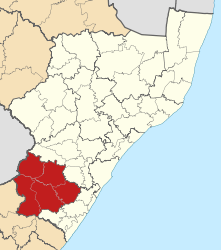
Symbole Wappen
Basisdaten Staat Südafrika Provinz KwaZulu-Natal Sitz Ixopo Fläche 10.109 km² Einwohner 500.079 (24. Oktober 2007) Dichte 49,5 Einwohner pro km² Schlüssel DC43 ISO 3166-2 ZA-ZN Webauftritt www.sisonke.gov.za (englisch) Politik Bürgermeister Jini Patrick Khoza -30.13333333333330.066666666667Koordinaten: 30° 8′ S, 30° 4′ OSisonke ist ein Distrikt in der Provinz KwaZulu-Natal in Südafrika. Er hat 500.079 Einwohner (Stand: 24. Oktober 2007)[1] auf einer Gesamtfläche von 10.109 km². Sitz der Distriktverwaltung ist Ixopo. [2]
Sisonke ist das Zulu Word für :wir sind zusammen. [3]
Inhaltsverzeichnis
Gemeinden (Local Municipalities)
Als Beispiel für die Infrastruktur hier die Wasserversorgung der Haushalte (HWA = eigener Hauswasseranschluss; ÖWA = öffentlicher Wasseranschluss in der Nähe; KWA = kein Anschluss an ein Wasserleitungsnetz) [4]:
Gemeinde Verwaltungssitz Fläche Einwohner HWA ÖWA KWA Greater Kokstad Kokstad 2.680 km² 57.035 7 % 75 % 18 % Ingwe Creighton 1.970 km² 108.068 2 % 31 % 67 % Kwa Sani Himeville 1.180 km² 15.309 Ubuhlebezwe Ixopo 1.604 km² 102.468 4 % 22 % 74 % Umzimkhulu Umzimkhulu 2.436 km² 174.338 Parks und Naturschutzgebiete
- Himeville Naturschutzgebiet
- Mount Currie Naturschutzgebiet
Weblinks
- Offizieller Internetauftritt (englisch)
Einzelnachweise
- ↑ Community Survey 2007. Basic Results. Statistics South Africa, 24. Oktober 2007, abgerufen am 29. Juni 2010 (englisch)..
Hinweise zu den Daten (englisch). - ↑ Verwaltungsgrenzen Südafrika
- ↑ Namensbedeutung Gemeinden
- ↑ Gemeindestatistik Südafrika
Distrikte von KwaZulu-NatalAmajuba | eThekwini | iLembe | Sisonke | Ugu | uMgungundlovu | Umkhanyakude | Umzinyathi | Uthukela | uThungulu | Zululand
Wikimedia Foundation.
Schlagen Sie auch in anderen Wörterbüchern nach:
Sisonke District Municipality — Sisonke is one of the 11 districts of KwaZulu Natal province of South Africa. The seat of Sisonke is Ixopo. The majority of its 298 392 people speak IsiZulu (2001 Census). The district code is DC43.GeographyNeighboursSisonke is surrounded by: *… … Wikipedia
Sisonke District Municipality — Admin ASC 2 Code Orig. name Sisonke District Municipality Country and Admin Code ZA.02.DC43 ZA … World countries Adminstrative division ASC I-II
Liste der Gemeinden in der Provinz KwaZulu-Natal — KwaZulu Natal mit eingezeichneten Distrikten und Gemeinden Die Liste der Gemeinden in der Provinz KwaZulu Natal führt alle Gemeinden (Local Municipalities) in der südafrikanischen Provinz KwaZulu Natal auf. KwaZulu Natal (KZN) ist in zehn… … Deutsch Wikipedia
Greater Kokstad (Gemeinde) — Greater Kokstad Greater Kokstad Local Municipality Greater Kokstad (rot) in KwaZulu Natal Staat: Südafrika … Deutsch Wikipedia
Umzimkhulu (Gemeinde) — Umzimkhulu Umzimkhulu Local Municipality Symbole … Deutsch Wikipedia
Liste der Gemeinden Südafrikas — Dies ist eine Liste der südafrikanischen Gemeinden. Inhaltsverzeichnis 1 Metropolgemeinden 2 Freistaat 2.1 Xhariep – Xhariep District Municipality (DC16) 2.2 … Deutsch Wikipedia
KwaZulu-Natal — This article is about a province of South Africa. For other and related uses, see Zululand. KwaZulu Natal Province of South Africa The Province of KwaZulu Natal … Wikipedia
Distrikte Südafrikas — (nummeriert) Südafrika ist in 52 Distrikte aufgeteilt. Es gibt 6 Metropolitan (gekennzeichnet mit *) und 46 District Municipalitys). Inhaltsverzeichnis 1 Westkap 2 Ostkap … Deutsch Wikipedia
Ingwe (Gemeinde) — Ingwe Ingwe Local Municipality Symbole … Deutsch Wikipedia
Kwa Sani (Gemeinde) — Kwa Sani Kwa Sani Local Municipality Symbole … Deutsch Wikipedia
Sisonke


18+
© Academic, 2000-2024
- Kontaktieren Sie uns: Unterstützung, Werbung
Wörterbücher Export, schritte mit PHP, Joomla, Drupal, WordPress, MODx.