- St. John the Baptist Parish
-
Verwaltung US-Bundesstaat: Louisiana Verwaltungssitz: Edgard Adresse des
Verwaltungssitzes:Parish Courthouse
1801 W. Airline Hwy.
La Place, LA 70068-3345Gründung: 1807 Gebildet aus: Original-Parish Vorwahl: 001 985 Demographie Einwohner: 45.924 (2010) Bevölkerungsdichte: 81 Einwohner/km² Geographie Fläche gesamt: 901 km² Wasserfläche: 334 km² Karte 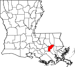
Website: www.sjbparish.com Das St. John the Baptist Parish[1] (frz.: Paroisse de Saint-Jean-Baptiste) ist ein Parish im Bundesstaat Louisiana der Vereinigten Staaten von Amerika. Im Jahr 2000 hatte das Parish 45.924 Einwohner und eine Bevölkerungsdichte von 81 Einwohner pro Quadratkilometer. Der Verwaltungssitz (Parish Seat) ist La Place.
Inhaltsverzeichnis
Geografie
Das Parish liegt im Südosten von Louisiana, ist im Osten und Süden jeweils etwa 80 km vom Golf von Mexiko entfernt und hat eine Fläche von 901 Quadratkilometern, wovon 334 Quadratkilometer Wasserfläche sind. Es grenzt an folgende Parishes:
Livingston Parish, Ascension Parish Tangipahoa Parish
St. James Parish 
Lafourche Parish St. Charles Parish Geschichte
St. John the Baptist Parish wurde 1807 als eines der 19 Original-Parishes gebildet.
Demografische Daten
Historische Einwohnerzahlen Census Einwohner ± in % 1810 2990 — 1820 3854 30 % 1830 5077 30 % 1840 5776 10 % 1850 7317 30 % 1860 7930 8 % 1870 6762 -10 % 1880 9686 40 % 1890 11.359 20 % 1900 12.330 9 % 1910 14.338 20 % 1920 11.896 -20 % 1930 14.078 20 % 1940 14.766 5 % 1950 14.861 0,6 % 1960 18.439 20 % 1970 23.813 30 % 1980 31.924 30 % 1990 39.996 30 % 2000 43.044 8 % 2010 45.924 7 % Vor 1900[2]  Karte des St. John the Baptist Parishes
Nach der Volkszählung im Jahr 2000 lebten im St. John the Baptist Parish 43.044 Menschen in 14.283 Haushalten und 11.312 Familien. Die Bevölkerungsdichte betrug 76 Einwohner pro Quadratkilometer. Ethnisch betrachtet setzte sich die Bevölkerung zusammen aus 52,58 Prozent Weißen, 44,76 Prozent Afroamerikanern, 0,26 Prozent amerikanischen Ureinwohnern, 0,53 Prozent Asiaten, 0,03 Prozent Bewohnern aus dem pazifischen Inselraum und 0,86 Prozent aus anderen ethnischen Gruppen; 0,98 Prozent stammten von zwei oder mehr Ethnien ab. 2,86 Prozent der Bevölkerung waren spanischer oder lateinamerikanischer Abstammung, die verschiedenen der genannten Gruppen angehörten.
Von den 14.283 Haushalten hatten 43,0 Prozent Kinder und Jugendliche unter 18 Jahre, die bei ihnen lebten. 56,1 Prozent waren verheiratete, zusammenlebende Paare, 18,1 Prozent waren allein erziehende Mütter, 20,8 Prozent waren keine Familien, 17,5 Prozent waren Singlehaushalte und in 6,0 Prozent lebten Menschen im Alter von 65 Jahren oder darüber. Die Durchschnittshaushaltsgröße betrug 2,98 und die durchschnittliche Familiengröße lag bei 3,38 Personen.
Auf das gesamte Parish bezogen setzte sich die Bevölkerung zusammen aus 31,2 Prozent Einwohnern unter 18 Jahren, 9,7 Prozent zwischen 18 und 24 Jahren, 30,2 Prozent zwischen 25 und 44 Jahren, 21,1 Prozent zwischen 45 und 64 Jahren und 7,8 Prozent waren 65 Jahre alt oder darüber. Das Durchschnittsalter betrug 32 Jahre. Auf 100 weibliche kamen statistisch 94,3 männliche Personen. Auf 100 Frauen im Alter von 18 Jahren oder darüber kamen 90,7 Männer.
Das jährliche Durchschnittseinkommen eines Haushalts betrug 39.456 USD, das Durchschnittseinkommen der Familien betrug 43.925 USD. Männer hatten ein Durchschnittseinkommen von 37.293 USD, Frauen 22.323 USD. Das Pro-Kopf-Einkommen betrug 15.445 USD. 13,9 Prozent der Familien 16,7 Prozent der Bevölkerung lebten unterhalb der Armutsgrenze. Davon waren 21,7 Prozent Kinder oder Jugendliche unter 18 Jahre und 17,8 Prozent waren Menschen über 65 Jahre. [7]
Städte und Gemeinden
- Belle Point
- Edgard
- Garyville
- LaPlace
- Lions
- Montz
- Mount Airy
- Reserve
- Wallace
Einzelnachweise
- ↑ St. John the Baptist Parish im Geographic Names Information System des United States Geological Survey Abgerufen am 10. März 2011
- ↑ U.S. Census Bureau - Census of Population and Housing. Abgerufen am 15. März 2011
- ↑ Auszug aus Census.gov. Abgerufen am 17. Februar 2011
- ↑ Auszug aus factfinder.census.gov Abgerufen am 18. Februar 2011
- ↑ United States Census 2010 Abgerufen am 13. März 2011
- ↑ Auszug aus dem National Register of Historic Places. Abgerufen am 13. März 2011
- ↑ St. John the Baptist Parish, Louisiana, Datenblatt mit den Ergebnissen der Volkszählung im Jahre 2000 bei factfinder.census.gov.
Weblinks
-
 Commons: Saint John the Baptist Parish, Louisiana – Sammlung von Bildern, Videos und Audiodateien
 - Offizielle Webseite
- St. John Parish Sheriff's Office
- St. John the Baptist Parish Clerk of Court
- www.city-data.com

Liste der Parishes in Louisiana
Acadia | Allen | Ascension | Assumption | Avoyelles | Beauregard | Bienville | Bossier | Caddo | Calcasieu | Caldwell | Cameron | Catahoula | Claiborne | Concordia | De Soto | East Baton Rouge | East Carroll | East Feliciana | Evangeline | Franklin | Grant | Iberia | Iberville | Jackson | Jefferson | Jefferson Davis | La Salle | Lafayette | Lafourche | Lincoln | Livingston | Madison | Morehouse | Natchitoches | Orleans | Ouachita | Plaquemines | Pointe Coupee | Rapides | Red River | Richland | Sabine | St. Bernard | St. Charles | St. Helena | St. James | St. John the Baptist | St. Landry | St. Martin | St. Mary | St. Tammany | Tangipahoa | Tensas | Terrebonne | Union | Vermilion | Vernon | Washington | Webster | West Baton Rouge | West Carroll | West Feliciana | Winn
Wikimedia Foundation.
Schlagen Sie auch in anderen Wörterbüchern nach:
St. John the Baptist parish — may refer to one of a number of religious organisations:In the district of Clontarf, Dublin, Ireland:* The Church of Ireland Parish of Clontarf * The senior Parish of Clontarf (Roman Catholic)It may also refer to St. John the Baptist Parish,… … Wikipedia
St John the Baptist Parish — Sp Señt Džòno Baptisto apýgarda Ap St John the Baptist Parish L JAV (Luiziana) … Pasaulio vietovardžiai. Internetinė duomenų bazė
Saint John the Baptist Parish — Admin ASC 2 Code Orig. name Saint John the Baptist Parish Country and Admin Code US.LA.095 US … World countries Adminstrative division ASC I-II
St. John the Baptist Parish, Louisiana — Infobox U.S. County county = Saint John the Baptist Parish state = Louisiana founded year = 1807 founded date = seat wl = Edgard largest city wl = LaPlace area total sq mi = 348 area total km2 = 901 area land sq mi = 219 area land km2 = 567 area… … Wikipedia
St. John the Baptist Parish School Board — is a school district headquartered in unincorporated St. John the Baptist Parish, Louisiana, United States. [ [http://www.sjbparish.com/services details.asp?dpID=25 School Board] . St. John the Baptist Parish .] It serves St. John the Baptist… … Wikipedia
National Register of Historic Places listings in St. John the Baptist Parish, Louisiana — Location of St. John the Baptist Parish in Louisiana This is a list of the National Register of Historic Places listings in St. John the Baptist Parish, Louisiana. This is intended to be a complete list of the properties and districts on the… … Wikipedia
John the Baptist — Saint John the Baptist John the Baptist by Bartolomeo Veneto 16th century Prophet, Preacher, Forerunner, Martyr Born c. 5 BC Died 3 … Wikipedia
St John the Baptist's Church, Chester — St John the Baptist s Church, Chester, from the northeast … Wikipedia
St. John the Baptist Catholic Church (Maria Stein, Ohio) — Maria Stein Catholic Church and Rectory U.S. National Register of Historic Places … Wikipedia
St John the Baptist's Church, Atherton — St John the Baptist The Parish Church of St John the Baptist, Atherton Atherton St John the Baptist … Wikipedia
St. John the Baptist Parish


18+
© Academic, 2000-2024
- Kontaktieren Sie uns: Unterstützung, Werbung
Wörterbücher Export, schritte mit PHP, Joomla, Drupal, WordPress, MODx.