Sutil Island

Sutil Island

w1

Santa Barbara Island
Kliffküste von Santa Barbara
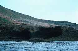
Gewässer Pazifischer Ozean
Inselgruppe Kanalinseln
Geographische Lage 33° 28′ 37″ N, 119° 2′ 16″ W33.476944444444-119.03777777778193Koordinaten: 33° 28′ 37″ N, 119° 2′ 16″ W
Länge 2,8 km
Breite 2,1 km
Fläche 2,625 km²dep1
Höchste Erhebung Signal Hill
193 m
Einwohner (unbewohnt)
Karte der Kanalinseln, Santa Barbara im Zentrum

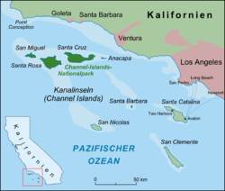
Santa Barbara Island ist eine kleine, unbewohnte Insel der kalifornischen Kanalinseln im Pazifik. Mit nur 2,625 km² stellt sie die kleinste Insel des Archipels dar und erreicht im Signal Hill eine Höhe von 193 Metern über dem Meer. Santa Barbara Island liegt rund 45 Kilometer westlich von Santa Catalina Island sowie 61 Kilometer südlich der kalifornischen Küste etwas isoliert im Zentrum der Channel Islands. Der Insel ist südwestlich das kleine Sutil Island (0,05 km²) vorgelagert. Santa Barbara Island gehört zum gleichnamigen County und ist Bestandteil des Channel-Islands-Nationalparks.

Geschichte

Die Insel wurde für Europa erstmals 1542 vom portugiesischen Entdecker Juan Rodríguez Cabrillo gesichtet und gut 60 Jahre später vom spanischen Entdecker Sebastián Vizcaíno nach der Heiligen Barbara benannt.

Weblinks


Wikimedia Foundation.

Игры ⚽ Нужен реферат?

Schlagen Sie auch in anderen Wörterbüchern nach:

  • Sutil Channel — is a channel, or strait, in British Columbia, Canada, located at the north end of the Strait of Georgia, between Quadra Island and Read Island to the west, and Cortes Island to the east. It connects to several channels to the north, including… …   Wikipedia

  • Santa Barbara Island — is a small island located about convert|50|mi|km off the southern California coast near Los Angeles.With a total area of about 640 acres (2.6 km²) it is the smallest of the eight Channel Islands of California. It is the southern most island in… …   Wikipedia

  • Santa Barbara Island — Kliffküste von Santa Barbara Gewässer Pazifischer Ozean …   Deutsch Wikipedia

  • CCGC Cape Sutil — is a Canadian Coast Guard Cape class lifeboat stationed at Port Hardy, British Columbia.cite news url=http://www.ccg gcc.gc.ca/vessels navires/results details e.asp?name=CAPE%20SUTIL title=Vessels, Aircraft and Hovercraft: CCGC Cape Sutil… …   Wikipedia

  • Gabriola Island — Infobox Settlement official name = Gabriola Island other name = native name = nickname = settlement type = Island motto = imagesize = image caption = Beach at Descanso Bay flag size = image seal size = image shield = shield size = city logo =… …   Wikipedia

  • Tales of Monkey Island — Desarrolladora(s) Telltale Games Distribuidora(s) LucasArts[1] Diseñador(es) …   Wikipedia Español

  • Galiano Island — Swiikw Hul q umín um   Island   View from Mount Galiano …   Wikipedia

  • Savary Island — is an island in British Columbia, Canada. Located in the northern part of the Strait of Georgia, it is convert|144|km|mi northwest of Vancouver. It is approximately convert|0.8|km|mi wide and convert|8|km|mi long. It has a permanent population of …   Wikipedia

  • Cortes Island — is located at the northern end of the Strait of Georgia. Geography Location Strait of Georgia Coordinates …   Wikipedia

  • Mayne Island —   Island   Village Bay, Mayne Island s ferry dock …   Wikipedia

Share the article and excerpts

Direct link
Do a right-click on the link above
and select “Copy Link”