Thong Sala

Thong Sala
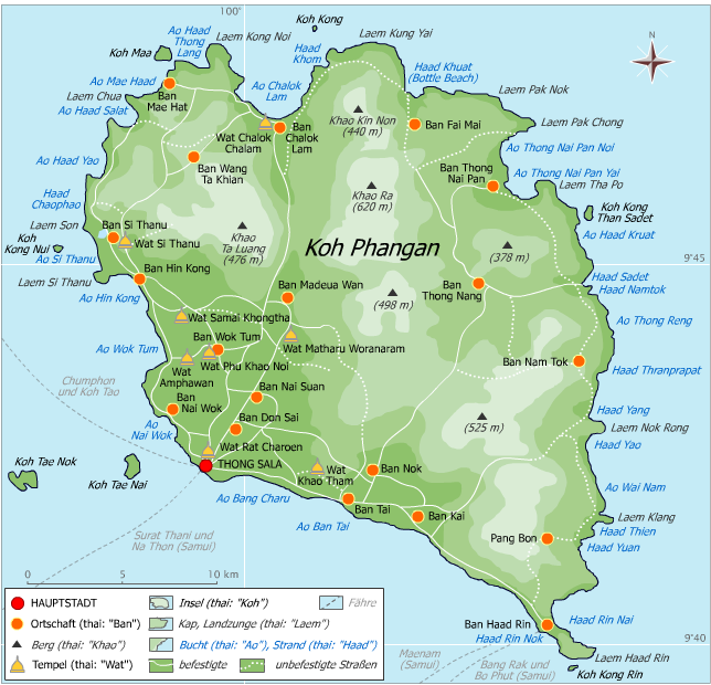
Karte von Ko Phangan
Songthaews am Hafen
Blick vom Pier

Thong Sala (thai: ท้องสาลา) ist die Hauptstadt der thailändischen Insel Phangan. Mit rund 5000 Einwohnern ist es der größte Ort der etwa 60 km nordöstlich des Festlandes im Golf von Thailand gelegenen Insel.

Etwa die Hälfte der Einwohner Phangans, darunter auch eine kleine chinesische Gemeinde, lebt in Thong Sala. Die Stadt im Südwesten der Insel ist deren wirtschaftliches und administratives Zentrum und mit drei Piers der bedeutendste Hafen. Hier befindet sich die einzige Anlegestelle der Fähren vom Festland (Chumphon, Surat Thani) und von der nördlichen Nachbarinseln Tao, sowie Anlegestellen für Fähren von der größeren südlichen Nachbarinsel Samui.

Von wirtschaftlicher Bedeutung ist der Ort als Hauptumschlagplatz für Waren aller Art sowie als Ankunfts- und Abreisestelle zahlreicher Touristen, die von hier mit Songthaews (Sammeltaxis) oder kleinen Fährbooten an die verschiedenen Orte und Strände der Insel weiterreisen.

In Thong Sala befinden sich eine Reihe von Reisebüros, Banken, eine Muay Thai-Arena, zahlreiche Restaurants und Bars sowie einige Hotels.

9.710833333333399.986944444444

Wikimedia Foundation.

Игры ⚽ Нужна курсовая?

Schlagen Sie auch in anderen Wörterbüchern nach:

  • Thong Sala — ( Tong saLaah ) is the principal town and administrative centre of Ko Pha Ngan, an island in the Gulf of Thailand. While Haad Rin hosts the Full Moon Party and attracts many of the island s more hedonistic visitors, Thong Sala is mostly used by… …   Wikipedia

  • Sala — is the name of: Geography * Sala Municipality a municipality in Sweden * Sala, Sweden a city in Sweden, seat of Sala Municipality * Šaľa, Slovakia a city in Slovakia * Sala a Roman city in Mauretania Tingitana, nowadays Morocco * Sala, Cambodia,… …   Wikipedia

  • Sala Xangkeo Hotel — (Луангпхабанг,Лаос) Категория отеля: 3 звездочный отель Адрес: 05/01 Sakkarine Ro …   Каталог отелей

  • Sala Ayutthaya — (Аюттхая,Таиланд) Категория отеля: 4 звездочный отель Адрес: U thong Road, Moo 4, Pra …   Каталог отелей

  • Amphoe Mueang Ang Thong — Mueang Ang Thong เมืองอ่างทอง Provinz: Ang Thong Fläche: 102,8 km² Einwohner: 49.401 (2000) Bev.dichte: 480,3 E./km² PLZ: 1 …   Deutsch Wikipedia

  • Mueang Ang Thong District — Mueang Ang Thong เมืองอ่างทอง   Amphoe   Amphoe location in Ang Thong Province …   Wikipedia

  • Amphoe Mueang Ang Thong — Infobox Amphoe name=Mueang Ang Thong thai=เมืองอ่างทอง province=Ang Thong coordinates=coord|14|35|19|N|100|27|12|E|region:TH type:adm2nd area=102.8 population=55,974 population as of=2007 density=544.5 postal code=14000 geocode=1501Mueang Ang… …   Wikipedia

  • Chom Thong District, Chiang Mai Province — Chom Thong จอมทอง   Amphoe   Amphoe location in Chiang Mai Province …   Wikipedia

  • Amphoe Chom Thong, Chiang Mai Province — Infobox Amphoe name=Chom Thong thai=จอมทอง province=Chiang Mai coordinates=coord|18|25|2|N|98|40|33|E|type:adm2nd region:TH area=712.297 population=65,162 population as of=2005 density=91.5 postal code=50160 geocode=5002Chom Thong ( th. จอมทอง)… …   Wikipedia

  • Ang Thong — Infobox Settlement official name = PAGENAME other name = native name = nickname = settlement type = motto = imagesize = image caption = flag size = image seal size = image shield = shield size = image blank emblem = blank emblem type = blank… …   Wikipedia

Share the article and excerpts

Direct link
Do a right-click on the link above
and select “Copy Link”