Vail (Arizona)

Vail (Arizona)
Vail
Pima County Incorporated and Unincorporated areas Vail highlighted.svg
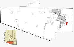
Lage im County und in Arizona
Basisdaten
Staat: Vereinigte Staaten
Bundesstaat: Arizona
County:

Pima County

Koordinaten: 32° 0′ N, 110° 42′ W32.001666666667-110.7986Koordinaten: 32° 0′ N, 110° 42′ W
Zeitzone: Mountain Standard Time (UTC−7)
Einwohner: 2484 (Stand: 2000)
Bevölkerungsdichte: 52,6 Einwohner je km²
Fläche: 47,2 km² (ca. 18 mi²)
davon 47,2 km² (ca. 18 mi²) Land
Höhe: 986 m
Postleitzahl: 85641
Vorwahl: +1 520
FIPS: 04-78540
GNIS-ID: 0013150
Webpräsenz: vailaz.com

Vail ist ein Census-designated place im Pima County im US-Bundesstaat Arizona. Sie hat 2484 Einwohner auf einer Fläche von 47,2 km². Die Bevölkerungsdichte liegt bei 52,7/km².

Verkehr

Vail liegt nahe der Kreuzung zwischen dem Interstate 10 und der Arizona State Route 83


Wikimedia Foundation.

Игры ⚽ Нужен реферат?

Schlagen Sie auch in anderen Wörterbüchern nach:

  • Vail (Arizona) — Vail Lugar designado por el censo de los Estados Unidos …   Wikipedia Español

  • Vail, Arizona — Infobox Settlement official name = Vail, Arizona settlement type = CDP imagesize = image caption = imagesize = image caption = mapsize = 250x250px map caption = Location in Pima County and the state of Arizona mapsize1 = map caption1 =… …   Wikipedia

  • Vail — steht für: Vail (Berg), Berg in den Rocky Mountains Vail steht für mehrere Ort in den Vereinigten Staaten: Vail (Arizona) Vail (Arkansas) Vail (Colorado) Vail (Iowa) Vail (Michigan) Vail (Washington) im weiteren Sinn für Vail Pass, Gebirgspass in …   Deutsch Wikipedia

  • Arizona State Highway 83 — Karte …   Deutsch Wikipedia

  • Vail — Vail, AZ U.S. Census Designated Place in Arizona Population (2000): 2484 Housing Units (2000): 906 Land area (2000): 18.205051 sq. miles (47.150863 sq. km) Water area (2000): 0.000000 sq. miles (0.000000 sq. km) Total area (2000): 18.205051 sq.… …   StarDict's U.S. Gazetteer Places

  • Vail, AZ — U.S. Census Designated Place in Arizona Population (2000): 2484 Housing Units (2000): 906 Land area (2000): 18.205051 sq. miles (47.150863 sq. km) Water area (2000): 0.000000 sq. miles (0.000000 sq. km) Total area (2000): 18.205051 sq. miles… …   StarDict's U.S. Gazetteer Places

  • Vail Charter High School — Infobox Secondary school name = Vail Charter High School principal = Dennis Barger grades = 9–12 established = 1997 address = 9040 S. Rita Rd city = Tucson state = Arizona country = USA enrollment = 210 mascot = Boxer colors = Blue and Silver… …   Wikipedia

  • Arizona State Route 83 — Karte …   Deutsch Wikipedia

  • Arizona State Route 83 — Infobox road marker state=AZ highway name= name notes= type=state route=83 alternate name= maint= length mi=53.63 length round=2 length ref=cite web |url=http://tpd.az.gov/data/reports/2006SHSLog.pdf |title=2006 ADOT Highway Log |author=Arizona… …   Wikipedia

  • Liste der Highways in Arizona — Dies ist eine Aufstellung von State Routes, U.S. Highways und Interstates im US Bundesstaat Arizona, nach Nummern. Inhaltsverzeichnis 1 State Routes 1.1 Gegenwärtige Strecken 1.2 Geplante Strecken 1.3 Außer Die …   Deutsch Wikipedia

Share the article and excerpts

Direct link
Do a right-click on the link above
and select “Copy Link”