- Vale of White Horse
-
Vale of White Horse District 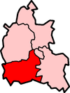
Lage in BerkshireStatus District Region South East England Verw.grafschaft Berkshire Verwaltungssitz Abingdon Fläche 578,63 km² (83.) Einwohner 117.000 (178.) ONS-Code 38UE Website www.whitehorsedc.gov.uk Vale of White Horse ist ein District in der Grafschaft Oxfordshire in England und ist nach dem Scharrbild Uffington White Horse benannt. Verwaltungssitz ist Abingdon; weitere bedeutende Orte sind Grove, Faringdon und Wantage.
Der Bezirk wurde am 1. April 1974 gebildet und entstand aus der Fusion des Municipal Borough Abingdon, des Urban District Wantage, der Rural Districts Abingdon und Faringdon sowie eines Teils des Rural District Wantage. Vor 1974 gehörte das gesamte Gebiet zur Verwaltungsgrafschaft Berkshire.
 Uffington White Horse
Cherwell | Oxford | South Oxfordshire | Vale of White Horse | West Oxfordshire
Wikimedia Foundation.
Schlagen Sie auch in anderen Wörterbüchern nach:
Vale of White Horse — Distrito del Reino Unido Ubicación en el condado de Oxfords … Wikipedia Español
Vale of White Horse — The Vale of White Horse is a local government district of Oxfordshire in England. The main town is Abingdon, other places include Faringdon and Wantage. There are 68 parishes within the district.It is a geographically distinct region, lying… … Wikipedia
Vale of White Horse — 51° 36′ N 1° 30′ W / 51.6, 1.5 … Wikipédia en Français
Vale of White Horse — Sp Váit Hòrso slėnis Ap Vale of White Horse L D. Britanijoje (Anglijoje) … Pasaulio vietovardžiai. Internetinė duomenų bazė
Vale of White Horse local elections — Vale of White Horse Council is elected every four years.Political controlConservative 1973 1995Liberal Democrat 1995 presentCouncil electionsVale of White Horse Council election, 1999Vale of White Horse Council election, 2003Vale of White Horse… … Wikipedia
Vale of White Horse Council election, 2003 — Elections to Vale of White Horse Council were held on 1st May, 2003. The whole council was up for election with boundary changes having taken place since the last election in 1999. The Liberal Democrats stayed in overall control of the… … Wikipedia
Vale of White Horse Council election, 1999 — Elections to Vale of White Horse Council were held on 6th May, 1999. The whole council was up for election and the Liberal Democrats stayed in overall control.Election ResultElection Summary Party party = Liberal Democrats (UK) seats = 33 gain =… … Wikipedia
Vale of White Horse — ▪ district, England, United Kingdom district, administrative county of Oxfordshire, historic county of Berkshire, England, lying southwest of Oxford. It encompasses the northern part of the historic county of Berkshire. Its principal… … Universalium
Drayton, Vale of White Horse — Coordinates: 51°38′49″N 1°18′47″W / 51.647°N 1.313°W / 51.647; 1.313 … Wikipedia
Milton, Vale of White Horse — Coordinates: 51°37′37″N 1°17′53″W / 51.627°N 1.298°W / 51.627; 1.298 … Wikipedia
Vale of White Horse


18+
© Academic, 2000-2024
- Kontaktieren Sie uns: Unterstützung, Werbung
Wörterbücher Export, schritte mit PHP, Joomla, Drupal, WordPress, MODx.