- Bayugan City
-
City of Bayugan Lage von Bayugan in der Provinz Agusan del Sur 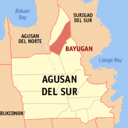
Basisdaten Bezirk: Caraga Provinz: Agusan del Sur Barangays: 43 Distrikt: 1. Distrikt von Agusan del Sur PSGC: 160301000 Einkommensklasse: unbekannt (1-6) Haushalte: 17.222 Zensus 1. Mai 2000Einwohnerzahl: 95.032 Zensus 1. August 2007Bevölkerungsdichte: 188,2 Einwohner je km² Fläche: 505,00 km² Koordinaten: 8° 51′ N, 125° 47′ O8.85522125.7756Koordinaten: 8° 51′ N, 125° 47′ O Offizielle Webpräsenz: www.bayugan.gov.ph Geographische Lage auf den Philippinen 

Bayugan City of Bayugan ist eine philippinische Stadt in der Provinz Agusan del Sur.
Bayugan ist ein Verkehrsknoten für den Ostteil der Insel Mindanao. Auf dem Gebiet der Stadt liegt der Naturpark Andanan Watershed Forest Reserve.
Baranggays
Bayugan ist politisch unterteilt in 43 Baranggays.
- Calaitan
- Charito
- Fili
- Hamogaway
- Katipunan
- Mabuhay
- Marcelina
- Maygatasan
- Noli
- Osmeña
- Panaytay
- Poblacion
- Mangga Chupoy
- Sagmone
- Saguma
- Salvacion
- San Isidro
- Santa Irene
- Taglatawan
- Verdu
- Del Carmen
- Berseba
- Bucac
- Cagbas
- Canayugan
- Claro Cortez
- Gamao
- Getsemane
- Grace Estate
- Magkiangkang
- Mahayag
- Montivesta
- Mt. Ararat
- Mt. Carmel
- Mt. Olive
- New Salem
- Pinagalaan
- San Agustin
- San Juan
- Santa Teresita
- Santo Niño
- Taglibas
- Tagubay
- Villa
Erhebung zur Stadt
Mit der Unterzeichnung des Republic Act No. 9405 am 23. März 2007 durch die philippinische Präsidentin Arroyo und der Annahme des Republic Act No. 9405 in einem Referendum durch die Bevölkerung von Bayugan am 22. Juni 2007, wurde Bayugan zur Stadt erhoben. In dem Referendum stimmten 13.907 Wähler für die Erhebung zur Stadt und 108 dagegen. Bayugan ist die erste Stadt der Provinz Agusan del Sur. Die Stadt trägt die offizielle Bezeichnung City of Bayugan.
Weblinks
Städte und Stadtgemeinden in der Provinz Agusan del SurStädte: Bayugan City
Stadtgemeinden: Bunawan | Esperanza | La Paz | Loreto | Prosperidad | Rosario | San Francisco | San Luis | Santa Josefa | Sibagat | Talacogon | Trento | Veruela
Wikimedia Foundation.
Schlagen Sie auch in anderen Wörterbüchern nach:
Bayugan City — Infobox Philippine city infoboxtitle = Bayugan City sealfile = locatormapfile = Ph locator agusan del sur bayugan.png caption = Map of Agusan del Sur showing the location of Bayugan. region = Caraga (Region XIII) province = Agusan del Sur… … Wikipedia
Bayugan — City of Bayugan Lage von Bayugan in der Provinz Agusan del Sur Basisdaten Bezirk: Caraga … Deutsch Wikipedia
Bayugan — Original name in latin Bayugan Name in other language Bayugan State code PH Continent/City Asia/Manila longitude 8.75611 latitude 125.7675 altitude 65 Population 40561 Date 2012 02 01 … Cities with a population over 1000 database
Davao City — Davao redirects here. For other uses, see Davao (disambiguation). City of Davao Dakbayan sa Dabaw Lungsod ng Dabaw Highly Urbanized City … Wikipedia
Zamboanga City — City of Zamboanga Ciudad de Zamboanga Chartered, Independent and Highly Urbanized City … Wikipedia
Iloilo City — City of Iloilo Ciudad sang Iloilo Highly urbanized City From top, left to right: Calle Real – Iloilo City s hist … Wikipedia
Masbate City — City of Masbate Ciudad nin Masbate Dakbayan sa Masbate Lungsod ng Masbate Nickname(s): City of Hearts, The Rodeo Capital of the Philippines, The Melting Pot of Diverse Cultures and Traditions in Central Philippines Motto: Aksyon Padayon! … Wikipedia
Quezon City — Lungsod Quezon City Clockwise from top left : C 5 Road going to Libis, Quezon Memorial Circle, Ka … Wikipedia
Cebu City — This article is about the city in the Philippines. For the province in the Philippines, see Cebu. City of Cebu Dakbayan sa Sugbo City … Wikipedia
Cotabato City — Cotabato City Mindanao River at Cotabato City … Wikipedia
Bayugan City


18+
© Academic, 2000-2024
- Kontaktieren Sie uns: Unterstützung, Werbung
Wörterbücher Export, schritte mit PHP, Joomla, Drupal, WordPress, MODx.