Bellingen Shire

Bellingen Shire
Shire of Bellingen
Australia-Map-NSW-LGA-Bellingen.png
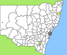
Lage des Bellingen Shire in New South Wales
Gliederung
Staat: Australien Australien
Bundesstaat: Flag of New South Wales.svg New South Wales
Verwaltungssitz: Bellingen
Daten und Zahlen
Fläche: 1.602 km²
Einwohner: 12.416 (2006) [1]
Bevölkerungsdichte: 7,8 Einwohner je km²
-30.45152.9

Das Bellingen Shire ist ein lokales Verwaltungsgebiet (LGA) im australischen Bundesstaat New South Wales. Das Gebiet ist 1.602 km² groß und hat etwa 12.000 Einwohner.

Bellingen liegt an der Ostküste Australiens etwa 520 km nördlich der Metropole Sydney und 430 km südlich von Brisbane. Das Gebiet umfasst 71 Ortsteile und Ortschaften, darunter Bellingen, Bostobrick, Deer Vale, Dorrigo, North Dorrigo, Gleniffer, Kalang, Megan, Mylestom, Raleigh, Thora und Urunga. Der Sitz des Shire Councils befindet sich in der Stadt Bellingen im Osten der LGA, wo etwa 1.600 Einwohner leben.

Verwaltung

Der Bellingen Shire Council hat sieben Mitglieder, sechs Councillor und ein Vorsitzender und Mayor (Bürgermeister), die von den Bewohnern der LGA gewählt werden. Bellingen ist nicht in Bezirke untergliedert.

Weblinks

Einzelnachweise

  1. Australian Bureau of Statistics (25. Oktober 2007): Bellingen (A) (Local Government Area) (Englisch). 2006 Census QuickStats. Abgerufen am 6. April 2010.

Wikimedia Foundation.

Игры ⚽ Нужна курсовая?

Schlagen Sie auch in anderen Wörterbüchern nach:

  • Bellingen Shire Council — Infobox Australian Place | type = lga name = Bellingen Shire state = nsw caption = Location in New South Wales pop = 12,758 publisher = Australian Bureau of Statistics title=Regional Population Growth, Australia, 2004 05 accessdate = 2006 12 03… …   Wikipedia

  • Bellingen, New South Wales — Infobox Australian Place | type = town name = Bellingen state = nsw caption = The Bellingen Valley From Above lga = Bellingen Shire Council postcode = 2454 pop = 2,721 pop footnotes=Census 2001 AUS|id=UCL106800|name=Bellingen (Urban… …   Wikipedia

  • Bellingen — /ˈbɛləndʒən/ (say beluhnjuhn) noun a town and shire in north eastern NSW; dairy and beef cattle and fruit growing district …  

  • Wakool Shire — Shire of Wakool New South Wales Location in New South Wales Population: 4,427(2009) …   Wikipedia

  • Nambucca Shire — New South Wales Location in New South Wales Population: 19,186(200 …   Wikipedia

  • Muswellbrook Shire — New South Wales Location in New South Wales Population …   Wikipedia

  • Conargo Shire — New South Wales Location in New South Wales Population: 1,700(2009) …   Wikipedia

  • Murray Shire — This article is about the Murray Shire in New South Wales. For the Western Australia shire, see Shire of Murray. Murray Shire New South Wales …   Wikipedia

  • Narrandera Shire — New South Wales Location in New South Wales Population: 6 …   Wikipedia

  • Cowra Shire — New South Wales Location in NSW Population: 12,945(2009) …   Wikipedia

Share the article and excerpts

Direct link
Do a right-click on the link above
and select “Copy Link”