- Yarbutenda
-
Yarbutenda 13.438444438889-13.880887268889{{{elevation_save}}}Koordinaten: 13° 26′ N, 13° 53′ W Region: Upper River Distrikt: Kantora Yarbutenda, Anfang des 20. Jahrhunderts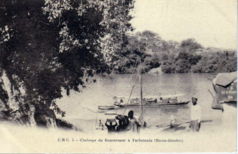
Yarbutenda (Schreibvariante: Yarbu Tenda oder französisch Yarboutenda) war bis Ende des 19. Jahrhundert mit Fattatenda eine französische Handelsniederlassung (auch Faktorei genannt) der Compagnie Française d'Afrique Occidentale im westafrikanischen Staat Gambia.[1]
Die Stelle liegt heute in der Upper River Region im Distrikt Kantora. Yarbutenda, ungefähr vier Kilometer von Koina und 42 Kilometer von Basse Santa Su entfernt, lag am Gambia-Fluss und hatte dort eine Anlegestelle.[2] Der Tidenhub des Atlantischen Ozeans ist bis hier, ungefähr 500 Fluss-Kilometer landeinwärts, noch bemerkbar.[3]
In der Geschichte Gambias waren die Grenzregion und die Faktorei immer umstritten, so wurde Yarbutenda mit dem Frieden von Utrecht (1713) von Königreich Großbritannien den Franzosen übergeben und später, im Jahr 1904, noch einmal.
Kultur und Sehenswürdigkeiten
Von der alten Siedlungsstelle Yarbutenda ist verlassendes Handelshaus übrig geblieben.[4]
Einzelnachweise
- ↑ Meyers Konversations-Lexikon
- ↑ The Atlas of the Gambia (englisch) von Dr. Malanding S. Jaiteh, Karte, Zugriff Mai 2010
- ↑ PMEDP The economic and social contribution of fisheries to the economic development of The Gambia PDF-Datei
- ↑ Allen Meagher, Andrew Samuel, Baba Ceesay, National Council for the Arts and Culture (Gambia) et al: Historic sites of The Gambia : an official guide to the monuments and sites of The Gambia. National Council for the Arts and Culture, Banjul, The Gambia 1998, ISBN 9983-80-011-014 (formal falsche ISBN)
Kategorien:- Wüstung in Gambia
- Geographie (Upper River Region)


Wikimedia Foundation.