- Breede Valley
-
Breede Valley
Breede Valley Local Municipality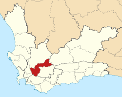
Basisdaten Staat Südafrika Provinz Westkap Distrikt Kapweinland Sitz Worcester Fläche 2.994 km² Einwohner 134.272 (24. Oktober 2007) Dichte 44,8 Einwohner pro km² Schlüssel WC025 ISO 3166-2 ZA-WC Webauftritt www.breedevallei.gov.za (englisch) Politik Bürgermeister Charles Ntsomi -33.63333333333319.416666666667Koordinaten: 33° 38′ S, 19° 25′ OBreede Valley ist eine Gemeinde im Distrikt Kapweinland, Provinz Westkap in Südafrika. Im Jahr 2001 betrug die Bevölkerung 146.023 auf einer Gesamtfläche von 2.994 km². Der Sitz der Gemeindeverwaltung ist Worcester.[1]
Benannt ist die Gemeinde nach dem afrikaans-Wort für „breit“. Im „breiten Tal“ fließt ebenfalls der Breede River.[2]
Inhaltsverzeichnis
Städte
- De Doorns
- Rawsonville
- Riverview
- Touwsrivier
- Worcester
Sehenswürdigkeiten
- Karoo Desert National Botanical Garden in Worcester
Weblinks
- Offizieller Internetauftritt (englisch)
Einzelnachweise
Gemeinden des Distriktes KapweinlandBreede River/Winelands | Breede Valley | Drakenstein | Stellenbosch | Witzenberg
Wikimedia Foundation.
Schlagen Sie auch in anderen Wörterbüchern nach:
Breede Valley Local Municipality — Zamuni code= WC025 location= Cape Winelands District Municipality, Western Cape Province area= 2.994 neighbours= mayor=Charles Ntsomi (ANC) population= 146,029 population density= habitations= habitation density= races= Black African : 20.13%… … Wikipedia
Breede River/Winelands — Local Municipality Breede River/Winelands (blau) im Distrikt Kapweinland (dunkelgrau) … Deutsch Wikipedia
Breede River/Winelands Local Municipality — Zamuni code= WC026 location= Cape Winelands District Municipality, Western Cape Province area= 3,334 neighbours= mayor= John Ngonyama (ANC) population= 81,271 population density= habitations= habitation density= races= languages= website=… … Wikipedia
Breede River Valley — is a region of Western Cape Province, South Africa known for being the largest fruit and wine producing valley in the Western Cape, as well as South Africa s leading race horse breeding area. It is part of the Little Karoo. How big is? From Gouda … Wikipedia
Worcester, Western Cape — Worcester Town Top: Dutch Reformed Church. Center left: Slave bell. Center right: Old house on Russell Street built in 1836. Bottom: View of Worcester looking north east … Wikipedia
South African wine — Some South African wines and cheeses Contents 1 … Wikipedia
Kap Weinland — Kapweinland Cape Winelands District Municipality Kapweinland (blau) in Westkap (dunkelgrau) Staat: Südafrika … Deutsch Wikipedia
Liste der Gemeinden Südafrikas — Dies ist eine Liste der südafrikanischen Gemeinden. Inhaltsverzeichnis 1 Metropolgemeinden 2 Freistaat 2.1 Xhariep – Xhariep District Municipality (DC16) 2.2 … Deutsch Wikipedia
Liste der Gemeinden in der Provinz Westkap — Die Provinz Westkap mit eingezeichneten Distrikten und Gemeinden Die Liste der Gemeinden in der Provinz Westkap führt alle Gemeinden (Local Municipalities) in der südafrikanischen Provinz Westkap auf. Die Provinz Westkap ist in 5 Distrikte… … Deutsch Wikipedia
West-Kap — Western Cape Wes Kaap Westkap Wappen Basisdaten Hauptstadt: Kapstadt (Cape Town, Kaapstad) Fläche: Rang … Deutsch Wikipedia
Breede Valley

18+
© Academic, 2000-2024
- Kontaktieren Sie uns: Unterstützung, Werbung
Wörterbücher Export, schritte mit PHP, Joomla, Drupal, WordPress, MODx.