- Brown County (Wisconsin)
-
Verwaltung US-Bundesstaat: Wisconsin Verwaltungssitz: Green Bay Adresse des
Verwaltungssitzes:County Courthouse
305 E. Walnut Street
Green Bay, WI 54305Gründung: 26. Oktober 1818 Gebildet aus: Michigan-Territorium Vorwahl: 001 920 Demographie Einwohner: 248.007 (2010) Bevölkerungsdichte: 181,2 Einwohner/km² Geographie Fläche gesamt: 1.594 km² Wasserfläche: 225 km² Karte 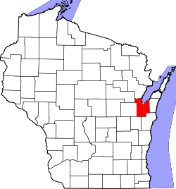
Website: www.co.brown.wi.us/ Brown County[2] ist ein County im Bundesstaat Wisconsin der Vereinigten Staaten von Amerika. Bei der Volkszählung im Jahr 2010 hatte das County 248.007 Einwohner und eine Bevölkerungsdichte von 181,2 Einwohnern pro Quadratkilometer. Der Verwaltungssitz (County Seat) ist Green Bay.
Inhaltsverzeichnis
Geografie
Das County liegt im Osten von Wisconsin, ist im Osten etwa 35 km vom Michigansee entfernt, im Nordosten grenzt es an eine Bucht des Michigansees und hat eine Fläche von 1594 Quadratkilometern, wovon 225 Quadratkilometer Wasserfläche sind. Es grenzt an folgende Countys:
Shawano County Oconto County Outagamie County 
Kewaunee County Calumet County Manitowoc County Geschichte
Das Brown County wurde am 26. Oktober 1818 aus dem Michigan-Territorium gebildet. Benannt wurde es nach Jacob Brown, einem Generalmajor und militärischen Führer im Krieg von 1812 und kommandierendem General der US-Armee von 1815 bis 1828.
Historische Objekte
In De Pere befindet sich das historische De Pere Lock and Dam Historic District. Das Gebiet der Schleuse umfasst zwei Objekte und wurde am 7. Dezember 1993 vom National Register of Historic Places als historisches Distrikt mit der Nummer 93001331 aufgenommen.[3]
Demografische Daten
Historische Einwohnerzahlen Census Einwohner ± in % 1900 46.359 — 1910 54.098 20 % 1920 61.889 10 % 1930 70.249 10 % 1940 83.109 20 % 1950 98.314 20 % 1960 125.082 30 % 1970 158.244 30 % 1980 175.280 10 % 1990 194.594 10 % 2000 226.778 20 % 2010 248.007 9 % 1900–1990[4] 2010[5]  Bevölkerungspyramide (2000) des Brown County
Nach der Volkszählung im Jahr 2000 lebten im Brown County 226.778 Menschen in 87.295 Haushalten. 57.527 Familien lebten im County. Die Bevölkerungsdichte betrug 166 Personen pro Quadratkilometer. Ethnisch betrachtet setzte sich die Bevölkerung zusammen aus 91,14 Prozent Weißen, 1,16 Prozent Afroamerikanern, 2,29 Prozent amerikanischen Ureinwohnern, 2,18 Prozent Asiaten, 0,03 Prozent Bewohnern aus dem pazifischen Inselraum und 1,9 Prozent aus anderen ethnischen Gruppen; 1,3 Prozent stammten von zwei oder mehr Ethnien ab. 3,84 Prozent der Bevölkerung waren spanischer oder lateinamerikanischer Abstammung, die verschiedenen der genannten Gruppen angehörten.
Von den 87.295 Haushalten hatten 33,9 Prozent Kinder unter 18 Jahren, die mit ihnen zusammen lebten. 53,2 Prozent davon waren verheiratete, zusammenlebende Paare, 8,9 Prozent waren allein erziehende Mütter. 34,1 Prozent waren keine Familien. 26,5 Prozent waren Singlehaushalte und in 8,4 Prozent lebten Menschen mit 65 Jahren oder älter. Die durchschnittliche Haushaltsgröße lag bei 2,51 und die durchschnittliche Familiengröße bei 3,08 Personen.
26,1 Prozent der Bevölkerung waren unter 18 Jahre alt, 10,5 Prozent zwischen 18 und 24, 31,9 Prozent zwischen 25 und 44, 20,9 Prozent zwischen 45 und 64, und 10,7 Prozent waren 65 Jahre oder älter. Das Durchschnittsalter betrug 34 Jahre. Auf 100 weibliche Personen kamen 98,9 männliche Personen. [6]
Städte und Gemeinden
- Allouez
- Ashwaubenon
- Bellevue
- Denmark
- De Pere
- Green Bay
- Hobart
- Howard1
- Pulaski2
- Suamico
- Wrightstown
1 - teilweise im Outagamie County
2 - teilweise im Oconto und im Shawano CountyEinzelnachweise
- ↑ Auszug aus dem National Register of Historic Places - Nr. 76000053 Abgerufen am 15. März 2011
- ↑ Brown County im Geographic Names Information System des United States Geological Survey. Abgerufen am 22. Februar 2011
- ↑ NRIS
- ↑ Auszug aus Census.gov. Abgerufen am 28. Februar 2011
- ↑ United States Census 2010 Abgerufen am 15. März 2011
- ↑ Brown County, Wisconsin, Datenblatt mit den Ergebnissen der Volkszählung im Jahre 2000 bei factfinder.census.gov.
Weblinks
-
 Commons: Brown County, Wisconsin – Sammlung von Bildern, Videos und Audiodateien
 - Offizielle Webseite
- www.city-data.com

Liste der Countys in Wisconsin
Adams | Ashland | Barron | Bayfield | Brown | Buffalo | Burnett | Calumet | Chippewa | Clark | Columbia | Crawford | Dane | Dodge | Door | Douglas | Dunn | Eau Claire | Florence | Fond du Lac | Forest | Grant | Green | Green Lake | Iowa | Iron | Jackson | Jefferson | Juneau | Kenosha | Kewaunee | La Crosse | Lafayette | Langlade | Lincoln | Manitowoc | Marathon | Marinette | Marquette | Menominee | Milwaukee | Monroe | Oconto | Oneida | Outagamie | Ozaukee | Pepin | Pierce | Polk | Portage | Price | Racine | Richland | Rock | Rusk | Sauk | Sawyer | Shawano | Sheboygan | St. Croix | Taylor | Trempealeau | Vernon | Vilas | Walworth | Washburn | Washington | Waukesha | Waupaca | Waushara | Winnebago | Wood
Wikimedia Foundation.
Schlagen Sie auch in anderen Wörterbüchern nach:
Brown County, Wisconsin — Infobox U.S. County county = Brown County state = Wisconsin map size = 225 founded = 1818 seat = Green Bay | area total sq mi =615 area land sq mi =529 area water sq mi =87 area percentage = 14.10% census yr = 2000 pop = 226778 density km2 =116… … Wikipedia
National Register of Historic Places listings in Brown County, Wisconsin — Buildings, sites, districts, and objects in Brown County listed on the National Register of Historic Places See also: National Register of Historic Places listings in Wisconsin This National Park Service list is complete through NPS recent… … Wikipedia
Lawrence, Brown County, Wisconsin — Infobox Settlement official name = Lawrence, Wisconsin settlement type = Town nickname = motto = imagesize = image caption = image mapsize = 250px map caption = Location of Lawrence, Wisconsin mapsize1 = map caption1 = subdivision type = Country… … Wikipedia
Eaton, Brown County, Wisconsin — Infobox Settlement official name = Eaton, Wisconsin settlement type = Town nickname = motto = imagesize = image caption = image mapsize = 250px map caption = Location of Eaton, Wisconsin mapsize1 = map caption1 = subdivision type = Country… … Wikipedia
Rockland, Brown County, Wisconsin — There are a few other places named Rockland in Wisconsin. Infobox Settlement official name = Rockland, Wisconsin settlement type = Town nickname = motto = imagesize = 250px image caption = Rockland town hall image mapsize = 250px map caption =… … Wikipedia
Scott, Brown County, Wisconsin — Infobox Settlement official name = Scott, Wisconsin settlement type = Town nickname = motto = imagesize = image caption = image mapsize = 250px map caption = Location of Scott, Wisconsin mapsize1 = map caption1 = subdivision type = Country… … Wikipedia
Holland, Brown County, Wisconsin — Infobox Settlement official name = Holland, Wisconsin settlement type = Town nickname = motto = imagesize = image caption = image mapsize = 250px map caption = Location of Holland, Wisconsin mapsize1 = map caption1 = subdivision type = Country… … Wikipedia
Brown County — is the name of nine counties in the United States: Brown County, Illinois Brown County, Indiana Brown County, Kansas Brown County, Minnesota Brown County, Nebraska Brown County, Ohio Brown County, South Dakota Brown County, Texas Brown County,… … Wikipedia
Brown County — In den Vereinigten Staaten neun Countys mit dem Namen Brown County: Brown County (Illinois) Brown County (Indiana) Brown County (Kansas) Brown County (Minnesota) Brown County (Nebraska) Brown County (Ohio) Brown County (South Dakota) Brown County … Deutsch Wikipedia
Brown County Reforestation Camp — The Brown County Reforestation Camp is an area of almost convert|1600|acre|km2 located in Brown County, Wisconsin. It has many trails and picnic areas, and is often used as winter recreation area.External links*… … Wikipedia
Brown County (Wisconsin)


18+
© Academic, 2000-2024
- Kontaktieren Sie uns: Unterstützung, Werbung
Wörterbücher Export, schritte mit PHP, Joomla, Drupal, WordPress, MODx.