- Bucks County
-
 Das Bucks County Courthouse in Doylestown
Verwaltung US-Bundesstaat: Pennsylvania Verwaltungssitz: Doylestown Adresse des
Verwaltungssitzes:55 East Court Street
Doylestown, PA 18901Gründung: November 1682 Vorwahl: 001 215 Demographie Einwohner: 625.249 (2010) Bevölkerungsdichte: 397,5 Einwohner/km² Geographie Fläche gesamt: 1.611 km² Wasserfläche: 38 km² Karte 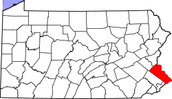
Website: www.buckscounty.org Das Bucks County[1] ist ein County im US-amerikanischen Bundesstaat Pennsylvania. Bei der Volkszählung im Jahr 2010 hatte das County 625.249 Einwohner und eine Bevölkerungsdichte von 397,5 Einwohnern pro Quadratkilometer. Der Verwaltungssitz (County Seat) ist Doylestown.
Das Bucks County ist Bestandteil der Metropolregion Delaware Valley.
Inhaltsverzeichnis
Geografie
Das County liegt im nördlichen Vorortbereich der Stadt Philadelphia am Delaware River, der im Osten die Grenze zu New Jersey bildet. Das Bucks County hat eine Fläche von 1.611 Quadratkilometern, wovon 38 Quadratkilometer Wasserfläche sind. Es grenzt an folgende Countys:
Lehigh County Northampton County Warren County (New Jersey),
Hunterdon County (New Jersey)Montgomery County 
Mercer County (New Jersey) Philadelphia Burlington County (New Jersey) Geschichte
 W. Penn
Das Bucks County wurde im November 1682 von William Penn als eines von drei Originalcountys von Pennsylvania gegründet und ursprünglich nach dessen Heimat Buckinghamshire benannt.
Demografische Daten
Historische Einwohnerzahlen Census Einwohner ± in % 1790 25.216 — 1800 27.496 9 % 1810 32.371 20 % 1820 37.842 20 % 1830 45.745 20 % 1840 48.107 5 % 1850 56.091 20 % 1860 63.578 10 % 1870 64.336 1 % 1880 68.656 7 % 1890 70.615 3 % 1900 71.190 0,8 % 1910 76.530 8 % 1920 82.476 8 % 1930 96.727 20 % 1940 107.715 10 % 1950 144.620 30 % 1960 308.567 100 % 1970 410.056 30 % 1980 479.211 20 % 1990 541.174 10 % 2000 597.635 10 % 2010 625.249 5 % Vor 1900[2] 1900–1990[3] 2000[4] 2010[5] Nach der Volkszählung im Jahr 2010 lebten im Bucks County 625.249 Menschen in 227.204 Haushalten. Die Bevölkerungsdichte betrug 397,5 Einwohner pro Quadratkilometer.
Ethnisch betrachtet setzte sich die Bevölkerung zusammen aus 89,2 Prozent Weißen, 3,6 Prozent Afroamerikanern, 0,2 Prozent amerikanischen Ureinwohnern, 3,8 Prozent Asiaten sowie aus anderen ethnischen Gruppen; 1,7 Prozent stammten von zwei oder mehr Ethnien ab. 4,3 Prozent der Bevölkerung waren spanischer oder lateinamerikanischer Abstammung, die verschiedenen der genannten Gruppen angehörten.
In den 227.204 Haushalten lebten statistisch je 2,66 Personen.
22,7 Prozent der Bevölkerung waren unter 18 Jahre alt, 62,9 Prozent waren zwischen 19 und 64 und 14,4 Prozent waren 65 Jahre oder älter. 50,7 Prozent der Bevölkerung war weiblich.
Das jährliche Durchschnittseinkommen eines Haushalts betrug 75.895 USD. Das Pro - Kopf - Einkommen betrug 35.039 USD. 4,2 Prozent der Einwohner lebten unterhalb der Armutsgrenze.[6]
Städte und Gemeinden
 Karte des Bucks Countys
Die Kommunen und sonstigen Siedlungen im Bucks County haben verschiedene Siedlungsformen. Bei Boroughs und bei für Pennsylvania typischen Home Rule Municipalities handelt es sich um selbstverwaltete Gemeinden. Siedlungen ohne Selbstverwaltung sind Census - designated places und Unincorporated Communities.
- Bristol
- Doylestown
- Dublin
- Hulmeville
- Ivyland
- Langhorne
- Langhorne Manor
- Morrisville
- New Britain
- New Hope
- Newtown
- Penndel
- Perkasie
- Quakertown
- Richlandtown
- Riegelsville
- Sellersville
- Silverdale
- Telford1
- Trumbauersville
- Tullytown
- Yardley
Home Rule Municipality
- Chalfont
Census-designated places (CDP)
- Churchville
- Croydon
- Fairless Hills
- Levittown
- Newtown Grant
- Richboro
- Village Shires
- Warminster Heights
- Woodbourne
- Woodside
- Erwinna
- Fallsington
- Southampton
- Uhlerstown
- Upper Black Eddy
1 - teilweise im Montgomery County
Einzelnachweise
- ↑ Bucks County im Geographic Names Information System des United States Geological Survey Abgerufen am 22. Februar 2011
- ↑ U.S. Census Bureau _ Census of Population and Housing Abgerufen am 28. Februar 2011
- ↑ Auszug aus Census.gov Abgerufen am 28. Februar 2011
- ↑ Auszug aus factfinder.census.gov Abgerufen am 28. Februar 2011
- ↑ United States Census 2010 Abgerufen am 15. August 2011
- ↑ U.S. Census Buero, State & County QuickFacts - Bucks County Abgerufen am 15. August 2011
Weblinks
-
 Commons: Bucks County, Pennsylvania – Sammlung von Bildern, Videos und Audiodateien
 - Offizielle Webseite
- U.S. Census Buero, State & County QuickFacts - Bucks County
- Yahoo Bildersuche - Bucks County
- www.city-data.com - Bucks County

Liste der Countys in Pennsylvania
Adams | Allegheny | Armstrong | Beaver | Bedford | Berks | Blair | Bradford | Bucks | Butler | Cambria | Cameron | Carbon | Centre | Chester | Clarion | Clearfield | Clinton | Columbia | Crawford | Cumberland | Dauphin | Delaware | Elk | Erie | Fayette | Forest | Franklin | Fulton | Greene | Huntingdon | Indiana | Jefferson | Juniata | Lackawanna | Lancaster | Lawrence | Lebanon | Lehigh | Luzerne | Lycoming | McKean | Mercer | Mifflin | Monroe | Montgomery | Montour | Northampton | Northumberland | Perry | Philadelphia | Pike | Potter | Schuylkill | Snyder | Somerset | Sullivan | Susquehanna | Tioga | Union | Venango | Warren | Washington | Wayne | Westmoreland | Wyoming | York
Wikimedia Foundation.
Schlagen Sie auch in anderen Wörterbüchern nach:
Bucks County — Admin ASC 2 Code Orig. name Bucks County Country and Admin Code US.PA.017 US … World countries Adminstrative division ASC I-II
Bucks County, Pennsylvania — Bucks County Courthouse … Wikipedia
Bucks County Sharks — Club information Full name Bucks County Sharks Rugby League Football Club Nickname(s) Sharks Founded 1997 Current details Ground(s) Falls Township Community Park … Wikipedia
Bucks County Council (Boy Scouts of America) — Bucks County Council Owner … Wikipedia
Bucks County Community College — (Bucks) is a two year community college located in Bucks County, Pennsylvania, near Philadelphia. Founded in 1964, Bucks has three campuses: a main campus in Newtown, an Upper County campus in the town of Perkasie, and a Lower County campus in… … Wikipedia
Bucks County Council — may refer to:*Buckinghamshire County Council, the administrative body governing the county of Buckinghamshire, England *A Council of the Boy Scouts of America in Pennsylvania: see Scouting in Pennsylvania … Wikipedia
Bucks County Playhouse — The Bucks County Playhouse is located in New Hope, Pennsylvania.Referenceshttp://www.buckscountyplayhouse.com/playhouse/frontpage/briefhistory.htmlExternal links* [http://www.buckscountyplayhouse.com buckscountyplayhouse.com] … Wikipedia
Bucks County Dragoons — The Bucks County Dragoons was a British provincial military unit raised for service during the American Revolutionary War.It was raised in Philadelphia in February, 1778. It returned with the army to New York in 1778. It was attached to the Queen … Wikipedia
Bucks County — … Useful english dictionary
Newtown, Bucks County, Pennsylvania — For other places in Pennsylvania with similar names, see Newtown, Pennsylvania. Coordinates: 40°13′42″N 74°55′56″W / 40.22833°N 74.93222°W / … Wikipedia
Bucks County


18+
© Academic, 2000-2024
- Kontaktieren Sie uns: Unterstützung, Werbung
Wörterbücher Export, schritte mit PHP, Joomla, Drupal, WordPress, MODx.