- Amphoe Chom Phra
-
Chom Phra
จอมพระProvinz: Surin Fläche: 314,0 km² Einwohner: 60.568 (2005) Bev.dichte: 192,9 E./km² PLZ: 32180 Geocode: 3204 Karte 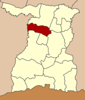
Amphoe Chom Phra (Thai: อำเภอ จอมพระ) ist ein Landkreis (Amphoe - Verwaltungs-Distrikt) in der Provinz Surin. Die Provinz Surin liegt in der Nordostregion von Thailand, dem so genannten Isaan.
Inhaltsverzeichnis
Geographie
Amphoe Chom Phra grenzt an die folgenden Distrikte (von Norden im Uhrzeigersinn): an die Amphoe Tha Tum, Sanom, Sikhoraphum, Khwao Sinarin und Mueang Surin in der Provinz Surin, sowie an Amphoe Satuek der Provinz Buriram.
Geschichte
Chom Phra wurde 1959 zunächst als Kleinbezirk (King Amphoe) eingerichtet, indem sein Gebiet vom Amphoe Tha Tum separiert wurde. Am 27. Juli 1965 wurde er offiziell zum Amphoe heraufgestuft.
Verwaltung
Amphoe Chom Phra ist in neun Kommunen (Tambon) eingeteilt, die sich weiter in 105 Dörfer (Muban) unterteilen.
Es gibt drei Kleinstädte (Thesaban Tambon) im Landkreis:
- Chom Phra (Thai: เทศบาลตำบลจอมพระ), bestehend aus Teilen des Tambon Chom Phra,
- Krahat (Thai: เทศบาลตำบลกระหาด), bestehend aus dem gesamten Tambon Krahat,
- Bu Kraeng (Thai: เทศบาลตำบลบุแกรง), bestehend aus dem gesamten Tambon Bu Kraeng.
Außerdem gibt es sieben „Tambon Administrative Organizations“ (TAO, องค์การบริหารส่วนตำบล – Verwaltungs-Organisationen) im Landkreis.
Nr. Name Thai Muban Einw. 1. Chom Phra จอมพระ 15 10.471 2. Mueang Ling เมืองลีง 18 10.729 3. Krahat กระหาด 9 3.979 4. Bu Kraeng บุแกรง 15 7.912 5. Nong Sanit หนองสนิท 10 6.918 6. Ban Phue บ้านผือ 11 5.599 7. Lum Rawi ลุ่มระวี 10 4.841 8. Chum Saeng ชุมแสง 7 4.978 9. Pen Suk เป็นสุข 10 5.141 Weblinks

Mueang Surin | Buachet | Chom Phra | Chumphon Buri | Lamduan | Kap Choeng | Prasat | Rattanaburi | Sangkha | Samrong Thap | Sanom | Sikhoraphum | Tha Tum | Khwao Sinarin | Non Narai | Phanom Dong Rak | Si Narong
Wikimedia Foundation.
Schlagen Sie auch in anderen Wörterbüchern nach:
Amphoe Chom Phra — Infobox Amphoe name=Chom Phra thai=จอมพระ province=Surin coordinates=coord|15|7|3|N|103|36|41|E|type:adm2nd region:TH area=314.0 population=60,568 population as of=2005 density=192.9 postal code=32180 geocode=3204Chom Phra ( th. จอมพระ) is a… … Wikipedia
Amphoe Chom Phra — Admin ASC 2 Code Orig. name Amphoe Chom Phra Country and Admin Code TH.29.1611124 TH … World countries Adminstrative division ASC I-II
Chom Phra District — Chom Phra จอมพระ Amphoe Amphoe location in Surin Province … Wikipedia
Chom Phra — Original name in latin Chom Phra Name in other language Amphoe Chom Phra, Ban Chom Phra, Chom Phra, King Amphoe Chom Phra, cxmphra State code TH Continent/City Asia/Bangkok longitude 15.11814 latitude 103.60743 altitude 141 Population 0 Date 2012 … Cities with a population over 1000 database
Amphoe Chom Thong — Chom Thong จอมทอง Provinz: Chiang Mai Fläche: 712,3 km² Einwohner: 65.162 (2005) Bev.dichte: 91,5 E./km² PLZ: 50160 … Deutsch Wikipedia
Amphoe Chom Thong (Chiang Mai) — Chom Thong จอมทอง Provinz: Chiang Mai Fläche: 712,3 km² Einwohner: 65.162 (2005) Bev.dichte: 91,5 E./km² PLZ: 50160 … Deutsch Wikipedia
Amphoe Chom Thong, Chiang Mai Province — Infobox Amphoe name=Chom Thong thai=จอมทอง province=Chiang Mai coordinates=coord|18|25|2|N|98|40|33|E|type:adm2nd region:TH area=712.297 population=65,162 population as of=2005 density=91.5 postal code=50160 geocode=5002Chom Thong ( th. จอมทอง)… … Wikipedia
Amphoe Khwao Sinarin — Khwao Sinarin เขวาสินรินทร์ Provinz: Surin Fläche: 189,7 km² Einwohner: 35.394 (2005) Bev.dichte: 186,6 E./km² PLZ: 32000 … Deutsch Wikipedia
Amphoe Mueang Surin — Mueang Surin เมืองสุรินทร์ Provinz: Surin Fläche: 915,1 km² Einwohner: 257.845 (2008) Bev.dichte: 281,8 E./km² PLZ: 32000 … Deutsch Wikipedia
Amphoe Sanom — Sanom สนม Provinz: Surin Fläche: 203,0 km² Einwohner: 45.268 (2005) Bev.dichte: 223,0 E./km² PLZ: 32160 … Deutsch Wikipedia
Amphoe Chom Phra


18+
© Academic, 2000-2024
- Kontaktieren Sie uns: Unterstützung, Werbung
Wörterbücher Export, schritte mit PHP, Joomla, Drupal, WordPress, MODx.