California State Route 127

California State Route 127
Straßenschild der California State Route 127
Karte
Karte der California State Route 127
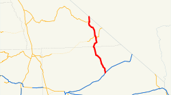
Basisdaten
Gesamtlänge:  90.89 mi/146.27 km
Anfangspunkt:  I-15.svg I-15 in Baker
Endpunkt:  Nevada 373.svg NV 373 an der Grenze zu Nevada
Countys:  San Bernardino County
Inyo County
Wichtige Stadt:  Baker

Die California State Route 127 (kurz CA 127) ist eine State Route im US-Bundesstaat Kalifornien. Sie verläuft teilweise durch den Death-Valley-Nationalpark.

Der Highway beginnt am Interstate 15 in Baker und geht an der Grenze zu Nevada in die Nevada State Route 373 über.

Siehe auch

Weblinks


Wikimedia Foundation.

Игры ⚽ Поможем написать реферат

Schlagen Sie auch in anderen Wörterbüchern nach:

  • California State Route 127 — State Route 127 Death Valley Road …   Wikipedia

  • California State Route 190 — State Route 190 Route information …   Wikipedia

  • California State Route 58 — State Route 58 Route information …   Wikipedia

  • California State Route 178 — Karte …   Deutsch Wikipedia

  • California State Route 178 — Infobox road state=CA type=SR route=178 section=478 maint=Caltrans length mi=166.81 length round=0 length ref=cite web|url=http://www.dot.ca.gov/hq/structur/strmaint/brlog2.htm|title=California Log of Bridges on State… …   Wikipedia

  • California State Route 126 — State Route 126 Route information …   Wikipedia

  • California State Route 41 — CA 41 redirects here. For the congressional district, see California s 41st congressional district. State Route 41 …   Wikipedia

  • California State Route 37 — CA 37 redirects here. For the congressional district, see California s 37th congressional district. State Route 37 …   Wikipedia

  • California State Route 128 — Infobox road state=CA type=SR route=128 section=428 maint=Caltrans length mi=120.52 length round=2 length ref= [ [http://www.dot.ca.gov/hq/structur/strmaint/brlog2.htm January 1, 2006 California Log of Bridges on State Highways] ] direction… …   Wikipedia

  • California State Route 36 — Infobox road state=CA type=SR route=36 section=336 maint=Caltrans length mi=250 length round=0 length ref= [ [http://www.dot.ca.gov/hq/structur/strmaint/brlog2.htm January 1, 2006 California Log of Bridges on State Highways] ] direction a=West… …   Wikipedia

Share the article and excerpts

Direct link
Do a right-click on the link above
and select “Copy Link”