- Crestway
-
Crestway 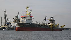
Crestway im Jahr 2010 vor Nordenham
Schiffsdaten Flagge Zypern Schiffstyp Baggerschiff Rufzeichen 5BLJ2 Eigner Royal Boskalis Westminster nv Bauwerft IHC Merwede B.V. Stapellauf 2008 Verbleib in Betrieb Schiffsmaße und Besatzung Länge 97,5 m (Lüa)Breite 21,6 m Tiefgang max. 7,1 m Vermessung 5500 GRT Besatzung 14 Maschine Maschinen-
leistung6776 kW Geschwindigkeit max. 15,5 kn (29 km/h) Ausstattung Baggertank 5600 m³
Baggertiefe 33 m
Saugrohrdurchmesser 1 m
Sonstiges Registrier-
nummernIMO-Nr.: 9420332
Die Crestway ist ein modernes Baggerschiff, das häufig auf deutschen Seeschifffahrtsstraßen Fahrwasser ausbaggert.
Das Schiff
Die Crestway arbeitet nach dem Prinzip eines Hopperbaggers. Das Baggerschiff hat an seiner Backbordseite ein Saugrohr, das es bei langsamer Fahrt auf den Gewässergrund herunterlässt um zu baggern. Im Schiff setzen sich die festen Bestandteile des Sauggutes ab und die Wasseranteile laufen zurück ins Wasser. Die festen Bestandteile des Sauggutes werden abtransportiert und können an anderer Stelle aufgespült werden. Die Crestway eignet sich daher besonders gut für das Ausbaggern von Häfen, Unterhalten von Fahrrinnen und Fahrwassern so wie das Aufspülen von Sand im Bereich des Küstenschutzes.
Das Schwesterschiff der Crestway mit gleichen Maßen und gleicher Ausstattung heißt Shoreway.
Weblinks
- Infos zum Schiff bei vesseltrecker.com
- Mehr Infos zum Schiff (englisch)
- Infos bei Sandgravel (englisch)
- Reedereiveröffentlichung zum neuen Schiff (niederländisch]

Wikimedia Foundation.