Dahlak Kebir

Dahlak Kebir

Vorlage:Infobox Insel/Wartung/Bild fehlt

Dahlak Kebir
Gewässer Rotes Meer
Inselgruppe Dahlak-Archipel
Geographische Lage 15° 34′ N, 40° 5′ O15.57222222222240.0888888888895Koordinaten: 15° 34′ N, 40° 5′ O
Dahlak Kebir (Eritrea)
Dahlak Kebir
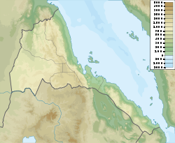
Länge 62 km
Breite 27 km
Fläche 754,9 km²
Höchste Erhebung m
Einwohner 1.500
2 Einw./km²
Hauptort Dahlak Kebir
Daklak Kebir im Dahlak-Archipel

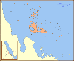
Dahlak Kebir ist die größte Insel des Dahlak-Archipels, der zu Eritrea gehört. Die im Roten Meer gelegene Insel wurde ursprünglich Dahlak Deset genannt. Die Insel ist 62 km lang und bis zu 27 km breit und weist eine Fläche von 754,9 km² auf. Mit einer maximalen Höhe von fünf Metern ist es eine sehr flache Insel.[1] Die etwa 1500 Dahalik sprechenden Bewohner leben vom Fischfang, der Seegurkenzucht und dem Tourismus.

Der an der Westküste gelegene Ort Dahlak Kebir ist für seine frühmittelalterliche Zisterne bzw. Nekropole bekannt. Des Weiteren finden sich auf dem Eiland viele Fossilien, die Überreste vorislamischer Kulturen in Adel sowie Mangrovensümpfe.

Es existieren Fährverbindungen nach Massawa und weiteren Inseln des Dahlak-Archipels.

Einzelnachweise

  1. UNEP

Wikimedia Foundation.

Игры ⚽ Поможем написать курсовую

Schlagen Sie auch in anderen Wörterbüchern nach:

  • Dahlak Kebir — Géographie Pays  Erythree !Érythrée Localisation Mer Rouge Coordon …   Wikipédia en Français

  • Dahlak Kebir — Dahlak Kebir …   Wikipedia

  • Dahlak-Archipel — Satellitenbild des östlichen Teils Gewässer Rotes Meer …   Deutsch Wikipedia

  • Dahlak District — Dahlak   District   Country  Eritrea Region …   Wikipedia

  • Dahlak Archipelago — The Dahlak Archipelago The Dahlak Archipelago (Ge ez: ዳህላክ) is an island group located in the Red Sea near Massawa, Eritrea. It consists of two large and 124 small islands. The pearl fisheries of the archipelago have been famous since Roman times …   Wikipedia

  • Dahlak — Dahlak, Inselgruppe des Roten Meers, ital. Kolonie Erythräa; Hauptinsel: D. el Kebir (Groß D.), Mittelpunkt des Fischfangs und der Perlenfischerei, etwa 1500 E …   Kleines Konversations-Lexikon

  • Archipel des Dahlak — Carte de l archipel des Dahlak. Géographie Pays …   Wikipédia en Français

  • Islas Dahlak — Islas Dahlak. Las islas Dahlak son un archipiélago situado en el Mar Rojo, frente al puerto eritreo de Massawa. Está formado por dos islas mayores y otros 124 islotes menores, con una superficie aproximada total de 1.165 km², Sólo cuatro de las… …   Wikipedia Español

  • Islas Dahlak — Las islas Dahlak son un archipiélago situado en el Mar Rojo, frente al puerto eritreo de Massawa. Consiste en dos islas mayores y otros 124 islotes menores. Sólo cuatro de las islas mayores están habitadas, de las cuales Dahlak Kebir es la mayor… …   Enciclopedia Universal

  • Dahalik — (dahālík) Gesprochen in Eritrea Sprecher 2500–3000 Linguistische Klassifikation Afroasiatische Sprachen Semitische Sprachen Westsemitische Sprachen Südwestsemitische Sprachen …   Deutsch Wikipedia

Share the article and excerpts

Direct link
Do a right-click on the link above
and select “Copy Link”