- Eauripik
-
Eauripik ISS-Foto von Eauripik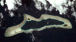
Gewässer Pazifischer Ozean Archipel Karolinen Geographische Lage 6° 42′ N, 143° 3′ O6.6916666666667143.04166666667Koordinaten: 6° 42′ N, 143° 3′ O 

Anzahl der Inseln 6 Hauptinsel Eauripik Island Länge 11 km Breite 3 km Landfläche 23,6 ha Lagunenfläche 5,921 km² Gesamtfläche 20 km² Einwohner 113 (2000) Eauripik (früher Kama Island) ist ein kleines Atoll im Pazifischen Ozean und liegt im Archipel der Karolinen. Eauripik ist das südlichste Atoll des Bundesstaats Yap, welcher gemeinsam mit drei anderen Bundesstaaten die Föderierten Staaten von Mikronesien bildet.
Inhaltsverzeichnis
Geographie
Das längliche Atoll zählt zu den Outer Islands von Yap. Auf dem breiten Riffkranz, welcher die zentrale Lagune vollständig umschliesst, liegen drei kleine Motu mit einer Landfläche von gut 0,2 km² und einer Lagunenfläche von 6 km²[1]. Hauptinsel ist Eauripik Island.
Auf dem Atoll leben 113 Menschen (Zensus 2000).[2]
Inseln
Die sechs Inseln liegen entlang der Nordseite des Riffkranzes, von West nach Ost[3]:
Insel (Name) Fläche
(ha)Lage Koordinaten Edarepe Yaetalhiipiy ... Westen 06° 41′ 20″ N, 143° 00′ 31″ O6.6888888888889143.00861111111 Elangkileku Aelangakiit ... Süden 06° 41′ 20″ N, 143° 03′ 36″ O6.6888888888889143.06 Oao Oau ... Norden 06° 42′ 12″ N, 143° 02′ 10″ O6.7033333333333143.03611111111 Bekefas Pigefash ... Süden 06° 41′ 24″ N, 143° 03′ 36″ O6.69143.06 Eauripik Aurepik ... Osten 06° 41′ 14″ N, 143° 04′ 55″ O6.6872222222222143.08194444444 Siteng Sitiing ... Ostspitze 06° 41′ 05″ N, 143° 05′ 12″ O6.6847222222222143.08666666667 Eauripik (Atoll) Kama Island 23,6 Saumriff 06° 42′ 00″ N, 143° 03′ 00″ O6.7143.05 Alle Inseln außer Edarepe sind mit Kokospalmen bestanden. Edarepe wird bei Hochwasser überspült.[4]
Die Inseln Elangkileku und Bekefas auf dem südlichen Riffkranz sind auf dem ISS-Foto nicht (mehr) auszumachen.
Einzelnachweise
- ↑ Otis W. Freeman, Geography of the Pacific, Wiley 1953
- ↑ World Gazetteer
- ↑ MapPlanet
- ↑ Sailing Directions Enroute, Vol. 126, Pacific Ocean
Weblinks
- Eauripik auf Oceandots (engl.)
- [1] Population Growth in three Pacific Ecosystems: Eauripik Atoll, American Samoa, and Hawaii. Eleanor C. Nordyke and Michael J. Levin, East-West Population Institute, Honolulu, Hawaii, May 29, 1979
 Inseln und Atolle von Yap (Föderierte Staaten von Mikronesien)
Hauptgruppe: Yap-Inseln: Yap | Gagil-Tomil | Maap | Rumung
Atolle: Ngulu | Ulithi | Turtle Islands | Zohhoiiyoru Bank | Sorol | Eauripik | Woleai | Faraulep | Ifalik | Lamolior | Elato | West Fayu | Olimarao | Lamotrek
Wikimedia Foundation.
Schlagen Sie auch in anderen Wörterbüchern nach:
Eauripik — is a small atoll in the state of Yap in the Federated States of Micronesia. It has an area of five and a half square miles.ources* Columbia Gazeteer of the World . Vol. 1, p. 900 … Wikipedia
Eauripik — Original name in latin Eauripik Name in other language State code FM Continent/City Pacific/Chuuk longitude 6.687 latitude 143.0375 altitude 9999 Population 0 Date 2011 01 12 … Cities with a population over 1000 database
Eauripik Municipality — Admin ASC 2 Code Orig. name Eauripik Municipality Country and Admin Code FM.04.ER FM … World countries Adminstrative division ASC I-II
Эаурипик — Эарипик англ. Eauripik … Википедия
Yap — Infobox Settlement name =Yap official name = other name = native name = nickname = settlement type =Island total type = motto = imagesize = image caption = flag size = image seal size = image shield = shield size = image blank emblem = blank… … Wikipedia
Habele — The Habele Outer Island Education Fund (or simply “Habele”) is a small South Carolina–based charitable organization serving the low lying atolls of Yap State and Chuuk State in the Federated States of Micronesia.[1] Habele serves the islands of… … Wikipedia
Woleai — Vorlage:Infobox Insel/Wartung/Höhe fehlt Woleai Lagekarte des Bundesstaates Yap Gewässer Pazifischer Ozean Archipel … Deutsch Wikipedia
Woléaï — L’île de Woléaï (ou Woleai, ou localement Wottegai) (7°22′N 143°54′E / 7.367, 143.9) est l’île principale de l’atoll de Woléaï (également appelé localement Wolea, Uleai … Wikipédia en Français
Liste der Inseln der Föderierten Staaten von Mikronesien — Karte der Föderierten Staaten von Mikronesien Die Liste der Inseln der Föderierten Staaten von Mikronesien listet alle Inseln, Inselgruppen und Atolle diese Inselstaates auf, geordnet alphabetisch nach Bundesstaat. Alle Inseln und Atolle gehören… … Deutsch Wikipedia
List of administrative divisions of Micronesia — Below is a list of administrative divisions of Micronesia. Cities of Micronesia *Colonia, Yap *Kolonia *Lelu *Palikir National capital *Tol *Weno Federated States of Micronesia Subdivisions Chuuk, State of * Dublon (Tonowas) * Eot * Ettal * Fala… … Wikipedia
Eauripik


18+
© Academic, 2000-2024
- Kontaktieren Sie uns: Unterstützung, Werbung
Wörterbücher Export, schritte mit PHP, Joomla, Drupal, WordPress, MODx.