- Exeter (Rhode Island)
-
Exeter 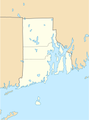

Exeter Lage in Rhode IslandBasisdaten Staat: Vereinigte Staaten Bundesstaat: Rhode Island County: Koordinaten: 41° 34′ N, 71° 36′ W41.563888888889-71.60555555555658Koordinaten: 41° 34′ N, 71° 36′ W Zeitzone: EST Einwohner: 6045 (Stand: 2000) Bevölkerungsdichte: 40,4 Einwohner je km² Fläche: 151,2 km² (ca. 58 mi²)
davon 149,5 km² (ca. 58 mi²) LandHöhe: 58 m Postleitzahl: 02822 FIPS: 44-25300 GNIS-ID: 1220087 Exeter ist ein Ort im Washington County in Rhode Island in den Vereinigten Staaten. Er liegt zwischen Connecticut im Osten und North Kingstown im Westen. Außerdem wird der Ort im Norden von West Greenwich und East Greenwich sowie im Süden von Hopkinton, Richmond und South Kingstown begrenzt. Die Postleitzahl von Exeter ist 02822. Hier lebten 6.045 Menschen nach dem Zensus von 2000.
Exeter wurde nach dem Earl of Exeter benannt.
Inhaltsverzeichnis
Geografie
Nach dem United States Census Bureau hat der Ort eine Gesamtfläche von 151,2 km², von denen 149,5 km² Land und 1,7 km² (1,15% der Gesamtfläche) Wasser sind.
Exeter hat zusammen mit West Greenwich ein öffentliches Schulsystem.
Geschichte
Exeter ist unter Folkloristen als die Stelle der am besten dokumentierten Vampir-Exhumierung: das Mercy Brown Vampirereignis von 1892.
Geplante Stadt Westconnaug
Im Februar 2008 schlug der Rhode Island State Repräsentant Nicholas Gorham der Legislatur die Bildung einer neuen Stadt, die die Landgemeinden inkl. Scituate umfassen soll, vor. Andere Orte die Teil der geplanten Stadt Westconnaug sein werden, sind West Greenwich, East Greenwich, Exeter, Foster, Glocester und der westliche Teil von Coventry.[1]
Attraktionen und historische Stätten in Exeter
- Yawgoo Valley ist das einzige Skigebiet in Rhode Island.
- Austin Farm Road Agricultural Area
- Baptist Church in Exeter
- Fisherville Historic and Archeological District
- Hallville Historic and Archeological District
- Lawton's Mill
- Simon Lillibridge Farm
- Parris Brook Historic and Archeological District
- Queen's Fort
- Sodom Mill Historic and Archeological District
Einzelnachweise
- ↑ Providence Journal 9. Februar 2008, Lawmaker proposes a super town made up of 5 towns and part of Coventry, by Lisa Vernon-Sparks
Weblinks
Kategorien:- Ort in Rhode Island
- Washington County (Rhode Island)

Wikimedia Foundation.