North East Island

North East Island
North East Island
Blick über North East Island Richtung Westen auf den höchsten Punkt der Insel
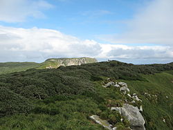
Gewässer Südpazifik
Inselgruppe Snaresinseln
Geographische Lage 48° 1′ 0″ S, 166° 36′ 0″ O-48.016666666667166.6130Koordinaten: 48° 1′ 0″ S, 166° 36′ 0″ O
North East Island (New Zealand Outlying Islands)
North East Island
Länge 3 km
Breite 2,5 km
Fläche 2,8 km²
Höchste Erhebung (unbenannt)
130 m
Einwohner (unbewohnt)
Karte der Snaresinseln

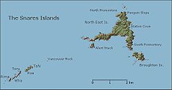
North East Island ist die größte Insel im Archipel der zu Neuseeland gehörenden Snaresinseln im südwestlichen Pazifischen Ozean, rund 200 km südlich der Südinsel Neuseelands gelegen.

Geographie

North East Island liegt, wie der Name vermuten lässt, im Nordosten der Snaresinseln. Die Insel hat die Form eines Dreiecks mit zwei langen Halbinseln als Verlängerung im Westen und im Süden. North East Island hat eine Länge von etwa 3 km in Ost-West-Richtung, eine Breite von 2,5 km in Nord-Süd-Richtung und weist eine Fläche von 280 ha[1] (2,8 km²) auf. Sie stellt somit die mit Abstand größte Insel der Inselgruppe dar. Südlich von North East Island liegt Broughton Island, die zweitgrößte Insel der Snaresinseln. Die Insel erreicht im äußersten Westen eine Höhe von 130 m über dem Meer,[2] was auch die höchste Erhebung der Inselgruppe darstellt.

Einzelnachweise

  1. IUCN World Commission on Protected Areas - Snares Islands Nature Reserve (PDF; englisch) (abgerufen am 1. September 2010)
  2. Detaillierte topographische Karte (abgerufen am 1. September 2010)

Wikimedia Foundation.

Игры ⚽ Нужен реферат?

Schlagen Sie auch in anderen Wörterbüchern nach:

  • North East Island — may refer to: North East Island National Park, Queensland, Australia North East Island, New Zealand, main island of the Snares Island group North East Isle (Tasmania), Australia North East Penang Island, Malaysia North and East Island group,… …   Wikipedia

  • North East Island National Park — IUCN Category II (National Park) Coordinates 21°39′57″S 150°20′11″E …   Wikipedia

  • North East Island, New Zealand — Looking South across North East Island across Punui Bay, Ho Ho Bay, Mollymawk Bay then Broughton Island the last wooded land. North East Island …   Wikipedia

  • North Manitou Island — North Manitou Island …   Wikipedia

  • North Jutlandic Island — Native name: Nørrejyske Ø The Grenen sand bar at the northern tip of the island …   Wikipedia

  • North Solitary Island — is one of the largest islands found off the New South Wales coast and inside the continental shelf. It is located 40 km north east of Coffs Harbour and about 13 km east south east of Wooli. The island is divided into two sections by a channel. An …   Wikipedia

  • North Hutchinson Island — North Hutchinson Island, Florida is an Atlantic coastal barrier island, lying north of the Fort Pierce Inlet in St. Lucie County, Florida. It is separated from the mainland by the Indian River Lagoon. North of the county line between St Lucie and …   Wikipedia

  • North Stradbroke Island — Nickname: Straddie NASA World Wind Landsat montage …   Wikipedia

  • North Brother Island — North Brother y South Brother Islands. North Brother Island es una isla del East River, situada entre el Bronx y Rikers Island, en Nueva York. Está situada a algunos centenares de metros en el norte de su homólogo, South Brother Island, y sus… …   Wikipedia Español

  • North Captiva Island — is an island in Lee County in Southwest Florida, located just offshore in the Gulf of Mexico. It lies just north of Captiva Island, separated by a channel called Redfish Pass which was created in a 1921 hurricane. It lies just south of Cayo Costa …   Wikipedia

Share the article and excerpts

Direct link
Do a right-click on the link above
and select “Copy Link”