Olavtoppen

Olavtoppen

f1

Olavtoppen
Höhe 780 m
Lage Bouvetinsel, Südatlantischer Ozean
Geographische Lage 54° 24′ 17″ S, 3° 20′ 52″ O-54.4047443.34774780Koordinaten: 54° 24′ 17″ S, 3° 20′ 52″ O
Olavtoppen (Südatlantik)
Olavtoppen
Bouvet Map.png

bdep2

Bouvet aerial photo.jpg

bdep3

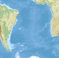
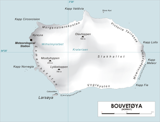
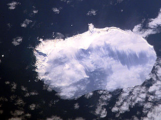
Olavtoppen ist mit 780 m Höhe der höchste Gipfel der zu Norwegen gehörenden Bouvetinsel im südatlantischen Ozean. Der Gipfel liegt auf dem Wilhelm-II-Plateau und ist wie 93% der Fläche der Insel vergletschert. Etwa zwei Kilometer nördlich des Gipfels liegt das Kap Valdivia, der nördlichste Punkt der Insel.

Weblinks


Wikimedia Foundation.

Игры ⚽ Нужно сделать НИР?

Schlagen Sie auch in anderen Wörterbüchern nach:

  • Bouvet-Insel — Bouvetinsel Bouvetøya Basisdaten Land: Norwegen Verwaltung: Forschungsstation: keine, (meteorologische Station) …   Deutsch Wikipedia

  • Bouvet Island — Bouvetinsel Bouvetøya Basisdaten Land: Norwegen Verwaltung: Forschungsstation: keine, (meteorologische Station) …   Deutsch Wikipedia

  • Bouvetinsel — Satellitenfoto der Bouvetinsel Gewässer Südatlantik G …   Deutsch Wikipedia

  • Bouvetoya — Bouvetinsel Bouvetøya Basisdaten Land: Norwegen Verwaltung: Forschungsstation: keine, (meteorologische Station) …   Deutsch Wikipedia

  • Bouvetøya — Bouvetinsel Bouvetøya Basisdaten Land: Norwegen Verwaltung: Forschungsstation: keine, (meteorologische Station) …   Deutsch Wikipedia

  • Ile Bouvet — Île Bouvet Pour les articles homonymes, voir Bouvet. Île Bouvet Bouvetøya (no) …   Wikipédia en Français

  • Île Bouvet — Pour les articles homonymes, voir Bouvet. Île Bouvet Bouvetøya (no) …   Wikipédia en Français

  • Isla Bouvet — Bouvetøya Vista de satélite de la isla (1 de junio de 2001) Localización País …   Wikipedia Español

  • Mid-Atlantic Ridge — The location of the Mid Atlantic Ridge The ridge was central in the breakup of Pangaea that began some 180 million years ago …   Wikipedia

  • Olav Peak — (Olavtoppen) is the highest point on Norway s subantarctic Bouvet island. It is located in the centre north of the island and rises to a height of 780 metres. It lies immediately to the south of Cape Valdivia, the island s northernmost point.… …   Wikipedia

Share the article and excerpts

Direct link
Do a right-click on the link above
and select “Copy Link”