- River Duddon
-
Duddon 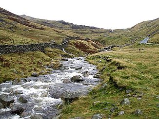
Der River Duddon auf dem Wrynose Pass
Daten Lage Lake District, Cumbria, England Flusssystem River Duddon Quelle auf dem Wrynose Pass
54° 24′ 59″ N, 3° 7′ 0″ W54.416276-3.116549Mündung nördlich der Morecambe Bay in die Irische See 54.169838-3.310299Koordinaten: 54° 10′ 11″ N, 3° 18′ 37″ W
54° 10′ 11″ N, 3° 18′ 37″ W54.169838-3.310299Länge 24 km bis Broughton-in-Furness (ohne Ästuar) Der River Duddon ist ein Fluss im Lake District in Cumbria in England.
Der Duddon entspringt auf dem Wrynose Pass und fließt über eine Strecke von 24 km in südlicher Richtung durch das Duddon Valley bis Broughton-in-Furness, wo er sich zu einem Mündungstrichter weitet; dieser mündet nördlich der Morecambe Bay in die Irische See.
Der Fluss ist die Heimat von Lachsen und bei Kajakfahrern mit Schwierigkeiten von III und teilweise IV beliebt.
Der Dichter William Wordsworth hat den Duddon in seinen Gedichten The River Duddon, A Series of Sonnets, die zwischen 1804 and 1820 entstanden, beschrieben.
Kategorien:- Fluss in Europa
- Fluss in England
- Lake District
- Cumbria

Wikimedia Foundation.