- Vanua Lava
-
Vanua Lava Karte von Vanua Lava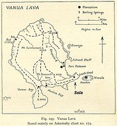
Gewässer Korallenmeer Inselgruppe Banks-Inseln Geographische Lage 13° 48′ S, 167° 28′ O-13.8167.46666666667921Koordinaten: 13° 48′ S, 167° 28′ O 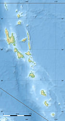

Länge 24 km Breite 19 km Fläche 334 km² Höchste Erhebung Mount Suretamate
921 mEinwohner 2.597 (2009)
7,8 Einw./km²Hauptort Sola Banks-Inseln mit Vanua Lava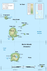
Vanua Lava ist eine Vulkaninsel in der Gruppe der Banks-Inseln im Norden des pazifischen Inselstaates Vanuatu. Sie ist nach Fläche und Bevölkerung die größte Insel der Banks-Inseln, vor Gaua, der zweitgrößten Insel.
Im Südosten von Vanua Lava liegt Sola, die Provinzhauptstadt der vanuatuischen Provinz Torba.
Der Ostküste vorgelagert sind einige kleine Nebeninseln wie Ravenga, Kwakéa und Niwula.
Vétaounde | Uréparapara | Rowa-Inseln | Mota Lava | Ra | Vanua Lava | Ravenga | Mota | Kwakéa | Niwula | Gaua | Mérig | Mere Lava
Wikimedia Foundation.
Schlagen Sie auch in anderen Wörterbüchern nach:
Vanua Lava — Carte de Vanua Lava datant de 1943 Géographie Pays … Wikipédia en Français
Vanua Lava — (coord|13.80|S|167.47|E) is one of the Banks Islands in Torba Province, Vanuatu. It is located about 120 km north northeast of Espiritu Santo, to the north of the slightly larger Gaua. Its population numbered 909 in 1979, and today is over… … Wikipedia
Vanua Lava — Vanua Lava, die bedeutendste der Banksinseln (s. d.) mit 2000 Einw … Meyers Großes Konversations-Lexikon
Vanua Lava — Vanua Lava, die größte der Banksinseln im Stillen Ozean, 352 qkm, 2000 E.; auf ihr Port Patterson … Kleines Konversations-Lexikon
Vanua Lava — [v , va], die größte der Banks Islands, Vanuatu, 352 km2, 900 melanesische Einwohner; erreicht mit dem Vulkan Mount Suretamatai (letzter schwerer Ausbruch 1965) 921 m über dem Meeresspiegel … Universal-Lexikon
Vanua Lava Airport — IATA: SLH – ICAO: NVSC … Wikipedia
Vanua Lava Island Airport — is an airport in Sola on Vanua Lava in Vanuatu airport codes|SLH|NVSC.Airlines and Destinations*Air Vanuatu (Luganville, Mota Lava, Torres) … Wikipedia
Vanua Lava — ▪ island, Vanuatu volcanic island in the Banks Islands of Vanuatu, southwestern Pacific Ocean, 75 miles (120 km) north northeast of Espiritu Santo. The island, 15 miles (24 km) long by 12 miles (19 km) wide, was first explored in 1859 by… … Universalium
Vanua — In Fijian and in Fiji English, vanua is an essential concept of indigenous Fijian culture and society. It is generally translated in English as land , but vanua as a concept encompasses a number of inter related meanings. When speaking in English … Wikipedia
Mota Lava — Gewässer Korallenmeer Inselgruppe Banks Inseln … Deutsch Wikipedia
Vanua Lava


18+
© Academic, 2000-2024
- Kontaktieren Sie uns: Unterstützung, Werbung
Wörterbücher Export, schritte mit PHP, Joomla, Drupal, WordPress, MODx.