- Willapa River
-
Willapa River 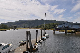
Willapa River bei Raymond
Daten Gewässerkennzahl US: 1509528 Lage Washington, Vereinigte Staaten Flusssystem Willapa River Ursprung Blaney Creek
46° 29′ 50″ N, 123° 24′ 47″ W46.4973259-123.4129257Mündung bei South Bend in die Willapa Bay 46.7075982-123.85044210Koordinaten: 46° 42′ 27″ N, 123° 51′ 2″ W
46° 42′ 27″ N, 123° 51′ 2″ W46.7075982-123.85044210Mündungshöhe 0 m Länge 32 km Einzugsgebiet 674 km²[1] Abflussmenge
am Pegel bei Willapa[2]NNQ: 790 l/s (im Jahr 1970)
MQ: 1,44 m³/s
HHQ: 6,43 m³/s (im Jahr 2007)Kleinstädte Raymond (Washington), South Bend Der Willapa River ist ein Fluss im Pacific County im Südwesten des US-Bundesstaats Washington. Er entspringt etwa 40 km westlich von Chehalis in den Willapa Hills. Er fließt nordwestlich und entwässert ein meist hügeliges Gebiet nördlich des Columbia River, bis er nach etwa 32 km bei South Bend in die Willapa Bay, einem großen Ästuar an der Pazikküste mündet.
Der Fluss ist benannt nach den Willapa, einem Athabaskischsprachigen Indianerstamm, der das Flusstal und die Region bis zu den Quellbächen des Chehalis und des Cowlitz River besiedelte[3].
Weblinks
- USGS Real Time Water Data: Willapa River
- Willapa River im Geographic Names Information System des United States Geological Survey
Einzelnachweise
- ↑ EPA: Washington - Willapa River. Abgerufen am 23. Juli 2011.
- ↑ USGS Real Time Water Data: Willapa River. Abgerufen am 23. Juli 2011.
- ↑ Curtis, Edward S.: The North American Indian. Volume 9 - The Salishan tribes of the coast. The Chimakum and the Quilliute. The Willapa. Seattle 1913, S. 154
Kategorien:- Fluss in Washington
- Fluss in Nordamerika

Wikimedia Foundation.