Williamtown (New South Wales)

Williamtown (New South Wales)
Williamtown
Williamtown Fighter World.jpg
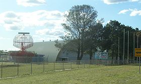
Flugzeugmuseum auf der RAAF Base Williamtown
Staat: Australien Australien
Bundesstaat: Flag of New South Wales.svg New South Wales
Koordinaten: 32° 49′ S, 151° 51′ O-32.815151.842777777789Koordinaten: 32° 49′ S, 151° 51′ O
Höhe: m [1]
Fläche: 44,9 km²
 
Einwohner: 826 (2006) [2]
Bevölkerungsdichte: 18 Einwohner je km²
 
Zeitzone: AEST (UTC +10)
Postleitzahl: 2318
LGA: Port Stephens Council
Williamtown (Australien)
Williamtown
Williamtown

Williamtown ist ein ländlicher Ort mit etwa 800 Einwohnern im australischen Bundesstaat New South Wales. Williamtown befindet sich 26 Kilometer nördlich von Newcastle und 15 Kilometer östlich von Raymond Terrace. Es liegt im Verwaltungsgebiet (LGA) Port Stephens Council.

Das Gebiet östlich von Williamstown ist dominiert von der RAAF Base Williamtown, einem Stützpunkt der australischen Luftwaffe, und dem Flughafen von Newcastle. Im Westen hingegen überwiegt ländliches Gebiet mit einigen größeren Anwesen. Im Süden von Williamtown liegt die Fullerton Cove, eine große Bucht des Hunter Rivers.

Bekannt ist der Ort auch durch seine Strände und das vor Küste liegende Wrack der Sygna. Der norwegische 50.000-Tonnen-Frachter lief hier 1974 nach einem Sturm auf Grund und brach auseinander.

Einzelnachweise

  1. Climate statistics for Australian locations (Williamtown RAAF) (Englisch). Australian Government - Bureau of Meteorologie. Abgerufen am 30. Dezember 2010.
  2. Australian Bureau of Statistics (25. Oktober 2007): Williamtown (State Suburb) (Englisch). 2006 Census QuickStats. Abgerufen am 28. Dezember 2010.

Wikimedia Foundation.

Игры ⚽ Нужно решить контрольную?

Schlagen Sie auch in anderen Wörterbüchern nach:

  • Williamtown, New South Wales — area = 44.9 area footnotes = ref|area|Note2 timezone = AEST utc = +10 timezone dst = AEDT utc dst = +11 propval = dist1 = 173 dir1 = NNE location1 = Sydney dist2 = 26 dir2 = N location2 = Newcastle dist3 = 15 dir3 = ESE location3 = Raymond… …   Wikipedia

  • Newcastle, New South Wales — This article is about the metropolitan area in Australia. For the local government area, see City of Newcastle. Newcastle New South Wales Central Newcastle to …   Wikipedia

  • Medowie, New South Wales — Medowie New South Wales …   Wikipedia

  • Mallabula, New South Wales — Mallabula New South Wales Main road of Mallabula Population …   Wikipedia

  • Osterley, New South Wales — Osterley New South Wales Coordinates …   Wikipedia

  • Corlette, New South Wales — Corlette New South Wales Population: 5,100[1] Note1 …   Wikipedia

  • Tomago, New South Wales — area = 38.1 area footnotes = ref|area|Note2 timezone = AEST utc = +10 timezone dst = AEDT utc dst = +11 propval = dist1 = 164 dir1 = N location1 = Sydney dist2 = 20 dir2 = NW location2 = Newcastle dist3 = 8 dir3 = S location3 = Raymond Terrace… …   Wikipedia

  • Cessnock, New South Wales — Cessnock New South Wales Cessnock, New South Wales …   Wikipedia

  • Duns Creek, New South Wales — Duns Creek New South Wales Population: 300[1]Note1 …   Wikipedia

  • Stockton Beach, New South Wales — Stockton Beach is located north of the Hunter River in New South Wales. It is Convert|32|km|mi|0|lk=on long and stretches from Stockton to Anna Bay. Over many years Stockton Beach has been the site of numerous shipwrecks and aircraft crash sites …   Wikipedia

Share the article and excerpts

Direct link
Do a right-click on the link above
and select “Copy Link”