- County Monaghan
-
County Monaghan
Contae MhuineacháinKarte 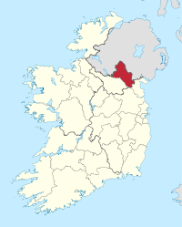
Basisdaten Staat: Irland Verwaltungssitz: Monaghan Provinz: Ulster irischer Name: Muineachán Fläche: 1296 km² Einwohner: 60.495 (2011) Kfz-Kennzeichen: MN Monaghan (irisch Muineachán) ist eine Grafschaft (county) in der Republik Irland.
Inhaltsverzeichnis
Geografie
Im Norden liegt ein Teil des Slieve Beagh auf dem Gebiet der Grafschaft, ein Plateau aus Kalkstein; in der Mitte erstreckt sich eine Niederung, die im Süden durch ein Hügelland begrenzt wird. Hier finden sich viele Seen und Moore.
Geschichte
Im Altertum gehörte das Gebiet zum Königreich Ulster und kam 332 zum neu gegründeten Königreich Oriel. Zwischen dem 14. Jahrhundert und 1589 war es im Besitz des irischen Herrscherhauses MacMahon. Im 17. Jahrhundert kam das Gebiet unter englische Herrschaft.
Politik
Die Sitzverteilung im County Council nach der Kommunalwahl vom 5. Juni 2009:
Partei Sitze Sinn Féin 7 Fine Gael 6 Fianna Fáil 5 Parteilose 2 Wirtschaft
Die Landwirtschaft beschränkt sich in der Hauptsache auf Rinder- und Schweinezucht. In Monaghan, Castleblayney, Carrickmacross und Clones findet sich Textil-, Möbel- und Zementindustrie.
Städte
Sehenswürdigkeiten
- Calliagh Wedge tomb
- Carn Court tomb
- County Monaghan Heritage Centre
- Leslie Castle
- Lisnadarragh Wedge tomb
- Mannan Castle
- Monaghan Cathedral
 Grafschaften (Countys) der Republik Irland
Carlow | Cavan | Clare | Cork | Donegal | Dublin | Galway | Kerry | Kildare | Kilkenny | Laois | Leitrim | Limerick | Longford | Louth | Mayo | Meath | Monaghan | Offaly | Roscommon | Sligo | Tipperary | Waterford | Westmeath | Wexford | Wicklow
Wikimedia Foundation.
Schlagen Sie auch in anderen Wörterbüchern nach:
County Monaghan — Coordinates: 54°14′37″N 7°02′22″W / 54.243563°N 7.039490°W / 54.243563; 7.039490 … Wikipedia
County Monaghan — Admin ASC 2 Code Orig. name County Monaghan Country and Admin Code IE.U.22 IE … World countries Adminstrative division ASC I-II
List of townlands in County Monaghan — This is a link page for townlands in County Monaghan in the Republic of Ireland. In any such case where two or more townlands share the same name, the Civil Parish in which the townland lies is denoted directly afterward in brackets. NOTOC AAcres … Wikipedia
Castleshane, County Monaghan — Castleshane is a small village on the outskirts of Monaghan town in the north of County Monaghan in Ireland. Castleshane or Caisléan an tSiáin in Irish, translates as the castle (or fort ) of the fairies and not the castle of Shane as most… … Wikipedia
List of civil parishes in County Monaghan — This is a link page for all twenty three civil parishes in County Monaghan in the Republic of Ireland. Alternative spellings of parish names are denoted directly afterward in brackets.*Aghabog *Aghnamullen *Ballybay *Clones *Clontibret *Currin… … Wikipedia
Monaghan County Council — Comhairle Contae Mhuineacháin Type Type County Council … Wikipedia
Monaghan (Dáil Éireann constituency) — Monaghan Former Dáil Éireann Parliamentary constituency 1921–1977 Seats 3 County/City council County Monaghan … Wikipedia
Monaghan (disambiguation) — Monaghan is a variant of the Gaelic manacháin, meaning little monk ,[1], and may refer to the following: Contents 1 Places 2 People … Wikipedia
Monaghan Way — Length 65 km (40 mi)[1] Location County Monaghan, Ireland Designation National Waymarked Trail[1] Trailheads Mon … Wikipedia
Monaghan County (Parliament of Ireland constituency) — Monaghan County Former County constituency Created () Post Union Type Irish House of Commons Monaghan County was a constituency represented in the Irish House of Commons until 1800. Members of Parliament … Wikipedia
County Monaghan

18+
© Academic, 2000-2024
- Kontaktieren Sie uns: Unterstützung, Werbung
Wörterbücher Export, schritte mit PHP, Joomla, Drupal, WordPress, MODx.