Crosshouse

Crosshouse
Crosshouse
Koordinaten 55° 37′ N, 4° 33′ W55.612222222222-4.5527777777778Koordinaten: 55° 37′ N, 4° 33′ W
Crosshouse (Schottland)
Crosshouse
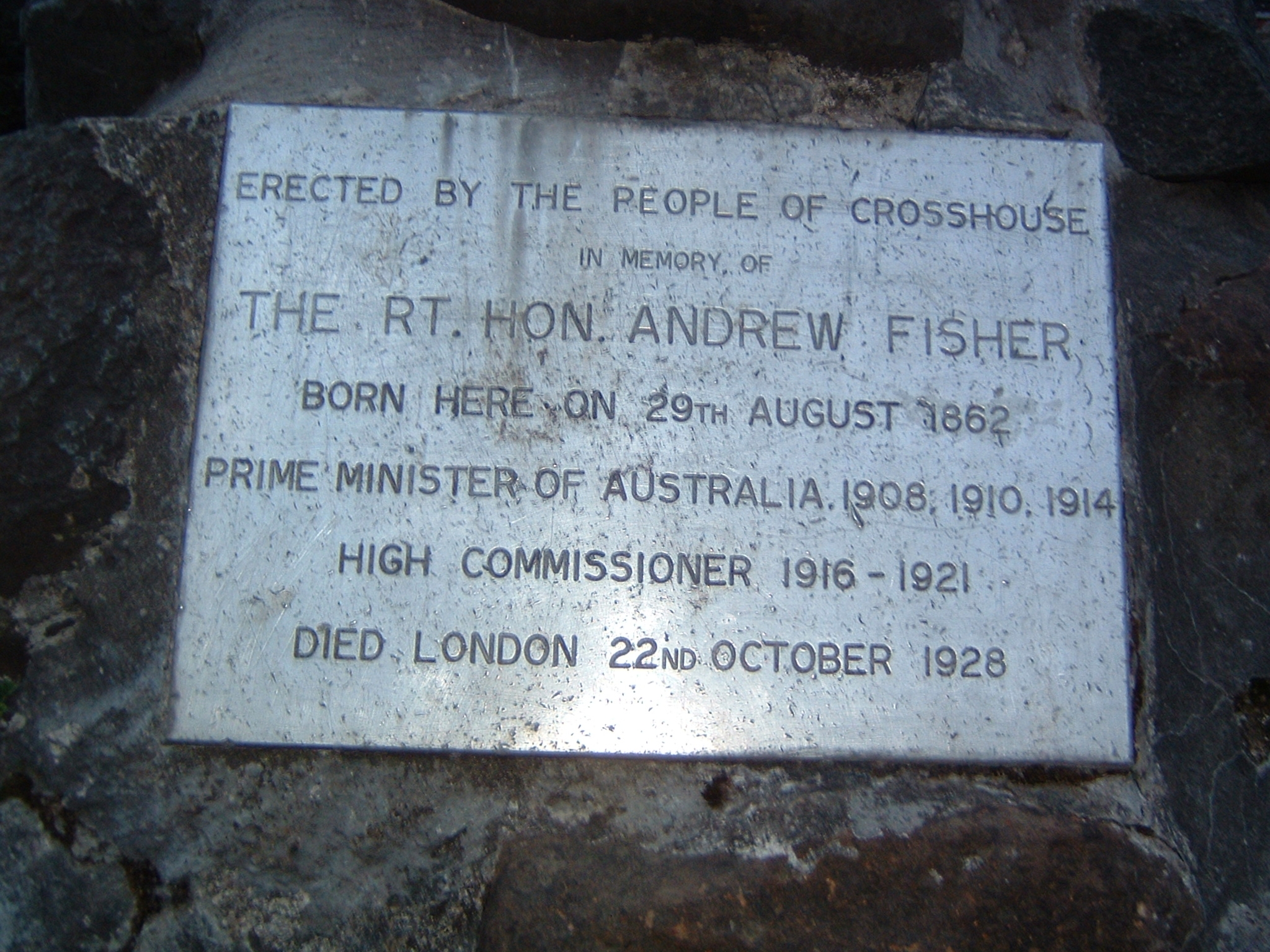
Crosshouse
Bevölkerung 2.454 (Zensus 2001)
Verwaltung
Post town KILMARNOCK
Postleitzahlen­abschnitt KA2
Landesteil Scotland
Unitary authority East Ayrshire
Britisches Parlament Kilmarnock and Loudoun
Schottisches Parlament Kilmarnock and Irvine Valley
Gedenkplakette für Andrew Fisher in seinem Geburtsort Crosshouse in Schottland

Crosshouse ist ein Dorf in Schottland und liegt in unmittelbarer Nachbarschaft zu der Stadt Kilmarnock in East Ayrshire.

Inhaltsverzeichnis

Geschichte

Crosshouse wurde im frühen neunzehnten Jahrhundert als Siedlung für die Bergleute, die in den zahlreichen Zechen der Gegend gearbeitet haben, gebaut und war bis 1882 Teil der Gemeinde Kilmaurs. Im Jahre 2001 hatte Crosshouse 2,454 Einwohner.[1] Es beherbergt das 1982 als Nachfolger der alten Kilmarnock Infirmary eingeweihte Krankenhaus Crosshouse Hospital, einem Hauptarbeitgeber der Region.

Persönlichkeiten

Einzelnachweise

  1. Scotland's Census Result OnLine

Weblinks


Wikimedia Foundation.

Игры ⚽ Поможем написать курсовую

Schlagen Sie auch in anderen Wörterbüchern nach:

  • Crosshouse — is a village located in East Ayrshire just outside Kilmarnock. The village even has its own hospital Crosshouse Hospital the hospital was built to replace the Kilmarnock Infirmary. The village takes you to Irvine then Ardrossan; the village… …   Wikipedia

  • Crosshouse —    CROSSHOUSE, a village, in the parish of Kilmaurs, district of Cunninghame, county of Ayr, 2½ miles (W. by N.) from Kilmarnock; containing 255 inhabitants. This place is situated on the western side of the Carmel water, and on the roads between …   A Topographical dictionary of Scotland

  • Crosshouse — Original name in latin Crosshouse Name in other language Crosshouse State code GB Continent/City Europe/London longitude 55.61258 latitude 4.55091 altitude 33 Population 2418 Date 2013 07 11 …   Cities with a population over 1000 database

  • Crosshouse Hospital — NHS Ayrshire and Arran Geography Location Crosshouse, East Ayrshire, Scotland, United Kingdom Organisation Care system …   Wikipedia

  • Crosshouse railway station — For the station on the East Kilbride Line, see Busby railway station. Crosshouse The site of Crosshouse in 2007 Location …   Wikipedia

  • Knockentiber — (Scottish Gaelic: Cnoc an Tobair , hill of the well) is a village in East Ayrshire, Parish of Kilmaurs, Scotland. Knockentiber is convert|2|mi|km WNW of Kilmarnock and 1/2 mile NE of Crosshouse. Latitude:55.6193°N Longitude:4.5455°W and… …   Wikipedia

  • Thorntoun house and estate — Thorntoun School was opened by Barnardo s in September 1971 for children with emotional difficulties aged 11 to 16 years. The school closed in 1990 and Thorntoun is now a Nursing Home. The complex lies between the villages of Springside (North… …   Wikipedia

  • Glasgow, Paisley, Kilmarnock and Ayr Railway — [v · d · …   Wikipedia

  • Gatehead, East Ayrshire — Infobox UK place official name= Gatehead gaelic name= scots name= local name= country= Scotland map type= Scotland population= population density= os grid reference= NS393364 edinburgh distance= london distance= latitude= 55.5955 longitude=… …   Wikipedia

  • Andrew Fisher — Infobox Prime Minister honorific prefix = The Right Honourable name=Andrew Fisher order=5th Prime Minister of Australia Elections: 1910, 1913, 1914 term start =13 November 1908 term end =2 June 1909 term start2 =29 April 1910 term end2 =24 June… …   Wikipedia

Share the article and excerpts

Direct link
Do a right-click on the link above
and select “Copy Link”