- Datu Unsay
-
Municipality of Datu Unsay Lage von Datu Unsay in der Provinz Maguindanao 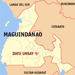
Basisdaten Bezirk: Autonomous Region in Muslim Mindanao Provinz: Maguindanao Barangays: 9 Distrikt: 2. Distrikt von Maguindanao PSGC: 153827000 Einkommensklasse: unbekannt (1-6) Haushalte: Zensus 1. Mai 2000Einwohnerzahl: 38.891 Zensus 1. August 2007Koordinaten: 6° 55′ N, 124° 27′ O6.9208333333333124.45333333333Koordinaten: 6° 55′ N, 124° 27′ O Offizielle Webpräsenz: www.datuunsayampatuan.gov.ph Geographische Lage auf den Philippinen 

Datu Unsay Datu Unsay ist eine philippinische Stadtgemeinde in der Provinz Maguindanao.
Datu Unsay wurde aus Baranggays, die zuvor zur Stadtgemeinde Shariff Aguak gehörten, gebildet.
Baranggays
Datu Unsay ist politisch in neun Baranggays unterteilt.
- Iganagampong
- Bulayan
- Macalag
- Maitumaig
- Meta
- Pamalian
- Panangeti
- Pikeg
- Tuntungan
Städte und Stadtgemeinden in der Provinz MaguindanaoStädte: Cotabato City
Stadtgemeinden: Ampatuan | Buluan | Datu Abdullah Sangki | Datu Anggal Midtimbang | Datu Paglas | Datu Piang | Datu Saudi-Ampatuan | Datu Unsay | Gen. S. K. Pendatun | Guindulungan | Mamasapano | Mangudadatu | Pagagawan | Pagalungan | Paglat | Pandag | Rajah Buayan | Shariff Aguak | South Upi | Sultan sa Barongis | Talayan | Talitay
Wikimedia Foundation.
Schlagen Sie auch in anderen Wörterbüchern nach:
Datu Unsay — Saltar a navegación, búsqueda Datu Unsay es un municipio filipino de la provincia de Maguindanao. Barangayes Datu Unsay se divide políticamente a 9 barangayes. Iganagampong Bulayan Macalag Maitumaig Meta Pamalian Panangeti Pikeg Tuntungan… … Wikipedia Español
Datu Unsay, Maguindanao — Map of Maguindanao showing the location of Datu Unsay Country Philippines Region … Wikipedia
Datu Piang, Maguindanao — Datu Piang Seal … Wikipedia
Datu Saudi-Ampatuan, Maguindanao — Datu Saudi biruar Ampatuan, Maguindanao Map of Maguindanao showing the location of Datu Saudi Ampatuan Country Philippines … Wikipedia
Datu Hoffer Ampatuan, Maguindanao — Datu Hoffer Ampatuan is a municipality in the province of Maguindanao, Philippines. According to the 2007 census, it has a population of at least 22,471 people (not counting the population of barangays only partially included). It was created out … Wikipedia
Datu Abdullah Sangki, Maguindanao — Map of Maguindanao showing the location of Datu Abdullah Sangki Country Philippines … Wikipedia
Datu Paglas, Maguindanao — Map of Maguindanao showing the location of Datu Paglas Coordinates … Wikipedia
Datu Anggal Midtimbang, Maguindanao — Country Philippines Region Autonomous Region in Muslim Mindanao Province Maguindanao Districts Lone district of Maguindanao … Wikipedia
Datu Salibo, Maguindanao — Datu Salibo is a municipality in the province of Maguindanao, Philippines. According to the 2007 census, it has a population of at least 13,876 people (not counting the population of barangays only partially included). It was created out of 4… … Wikipedia
Datu Abdullah Sangki — Municipality of Datu Abdullah Sangki Lage von Datu Abdullah Sangki in der Provinz Maguindanao Basisdaten … Deutsch Wikipedia
Datu Unsay


18+
© Academic, 2000-2024
- Kontaktieren Sie uns: Unterstützung, Werbung
Wörterbücher Export, schritte mit PHP, Joomla, Drupal, WordPress, MODx.