- Dumalneg
-
Municipality of Dumalneg Lage von Dumalneg in der Provinz Ilocos Norte 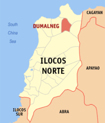
Basisdaten Bezirk: Ilocos-Region Provinz: Ilocos Norte Barangays: 1 Distrikt: 1. Distrikt von Ilocos Norte PSGC: 012810000 Einkommensklasse: 5. Einkommensklasse Haushalte: 239 Zensus 1. Mai 2000Einwohnerzahl: 1.716 Zensus 1. August 2007Bevölkerungsdichte: 19,4 Einwohner je km² Fläche: 88,48 km² Koordinaten: 18° 30′ N, 120° 49′ O18.5120.81666666667Koordinaten: 18° 30′ N, 120° 49′ O Geographische Lage auf den Philippinen 

Dumalneg Dumalneg ist eine Stadtgemeinde in der philippinischen Provinz Ilocos Norte. Im Jahre 2000 lebten in dem 88.48 km² großen Gebiet 1486 Einwohner, wodurch sich eine Bevölkerungsdichte von etwa 17 Einwohnern pro km² ergibt. Dumalneg ist nur in ein Baranggay aufgeteilt. Das Gebiet ist sehr bergig und schwer zu bewirtschaften. Mehrere Flüsse und Bäche fließen durch das Gebiet und bilden viele kleine Täler.
Städte und Stadtgemeinden in der Provinz Ilocos NorteStädte: Batac | Laoag City
Stadtgemeinden: Adams | Bacarra | Badoc | Bangui | Banna | Burgos | Carasi | Currimao | Dingras | Dumalneg | Marcos | Nueva Era | Pagudpud | Paoay | Pasuquin | Piddig | Pinili | San Nicolas | Sarrat | Solsona | Vintar
Wikimedia Foundation.
Schlagen Sie auch in anderen Wörterbüchern nach:
Dumalneg — Original name in latin Dumalneg Name in other language Dumalneg State code PH Continent/City Asia/Manila longitude 18.5254 latitude 120.8094 altitude 54 Population 0 Date 2011 07 31 … Cities with a population over 1000 database
Dumalneg, Ilocos Norte — Dumalneg Municipality Map of Ilocos Norte showing the location of Dumalneg … Wikipedia
Adams (Philippinen) — Municipality of Adams Lage von Adams in der Provinz Ilocos Norte Basisdaten Bezirk … Deutsch Wikipedia
Burgos (Philippinen) — Municipality of Burgos Lage von Burgos in der Provinz Ilocos Norte Basisdaten Bezirk: Ilocos Region … Deutsch Wikipedia
Laoag — City Siudad ti Laoag Lage von Laoag in der Provinz Ilocos Norte Basisdaten Bezirk: Ilocos Region … Deutsch Wikipedia
PH-ILN — Provinz Ilocos Norte Basisdaten Bezirk: Ilocos Region … Deutsch Wikipedia
Currimao, Ilocos Norte — Currimao Municipality Map of Ilocos Norte showing the location of Currimao … Wikipedia
Dingras, Ilocos Norte — Dingras Ili ti Dingras Bayan ng Dingras Municipality Map of Ilocos Norte sho … Wikipedia
Marcos, Ilocos Norte — Marcos Municipality Map of Ilocos Norte showing the location of Marcos … Wikipedia
Nueva Era, Ilocos Norte — Nueva Era Municipality Map of Ilocos Norte showing the location of Nueva Era … Wikipedia
Dumalneg


18+
© Academic, 2000-2024
- Kontaktieren Sie uns: Unterstützung, Werbung
Wörterbücher Export, schritte mit PHP, Joomla, Drupal, WordPress, MODx.