- Earra-Ghaidheal agus Bod
-
Argyll and Bute
Earra-Ghaidheal agus Bòd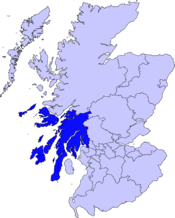
Verwaltungssitz Lochgilphead Fläche 6.909 km² (2.) Einwohner (2005) 90.870 (23.) ISO 3166-2 GB-AGB ONS-Code 00QD Website www.argyll-bute.gov.uk Argyll and Bute (Gälisch Earra-Ghaidheal agus Bòd) ist eine von 32 unitary authorities in Schottland. Sie grenzt an Highland, Perth and Kinross, Stirling und West Dunbartonshire. Die östliche Grenze verläuft durch den Loch Lomond. Der Verwaltungssitz ist in Lochgilphead.
Der größte Teil des Verwaltungsbezirks gehörte einst zur traditionellen Grafschaft Argyll, mit Ausnahme der Region Morvern nördlich von Mull, das heute zu Highland gehört. Der Bezirk umfasst auch die im Firth of Clyde liegende Isle of Bute, die zur traditionellen Grafschaft Bute gehörte sowie den westlichen Teil der traditionellen Grafschaft Dunbartonshire.
Inhaltsverzeichnis
Orte
- Achahoish
- Appin
- Ardbeg
- Ardlui
- Ardrishaig
- Arrochar
- Barcaldine
- Bellochantuy
- Bowmore
- Cardross
- Carradale
- Campbeltown
- Craighouse
- Craignure
- Crinan
- Dunoon
- Helensburgh
- Innellan
- Inveraray
- Kilcreggan
- Kilmartin
- Kilmore
- Kilmun
- Loch Awe
- Lochgilphead
- Lochgoilhead
- Luss
- Millhouse
- Oban
- Peninver
- Port Askaig
- Port Bannatyne
- Port Ellen
- Portnahaven
- Rothesay
- Saddell
- Salen
- Sandbank
- Southend
- Tarbert
- Tarbet
- Tobermory
Sehenswürdigkeiten
- Argyll Forest Park
- Carrick Castle
- Cruachan Dam
- Fincharn Castle
- Gare Loch
- Kilchurn Castle
- Loch Lomond
- Lachlan Castle
- Loch Doon Castle
- Younger Botanic Garden
- Fingal's Cave
Inseln
Politik
Der Council von Argyll and Bute umfasst 36 Sitze, die sich wie folgt auf die Parteien verteilen:[1]
Partei Sitze Unabhängig 15 Scottish National Party 10 Liberal Democrats 8 Scottish Conservatives 3 Quellen
- ↑ Argyll and Bute Council: http://www.argyll-bute.gov.uk/yourcouncil/councillors/cllrlist Argyll and Bute Councillors List (Abgerufen am 13.4.2008)

Aberdeen | Aberdeenshire | Angus | Argyll and Bute | Clackmannanshire | Dumfries and Galloway | Dundee | East Ayrshire | East Dunbartonshire | East Lothian | East Renfrewshire | Edinburgh | Falkirk | Fife | Glasgow | Highland | Inverclyde | Midlothian | Moray | Äußere Hebriden | North Ayrshire | North Lanarkshire | Orkney | Perth and Kinross | Renfrewshire | Scottish Borders | Shetland | South Ayrshire | South Lanarkshire | Stirling | West Dunbartonshire | West Lothian

Wikimedia Foundation.