- Furneaux Group
-
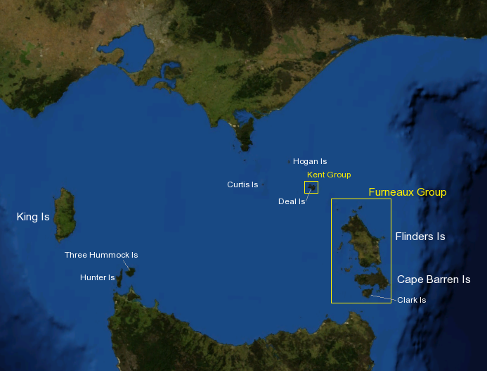
 Bass Strait mit Darstellung der Inselgruppen
Die Furneaux-Gruppe (engl. Furneaux Group) ist eine aus 52 Inseln bestehende Inselgruppe am Ostende der Bass Strait zwischen den australischen Bundesstaaten Victoria und Tasmanien.
Die Inseln wurden nach dem britischen Entdecker Tobias Furneaux benannt, der das Gebiet 1773 erforschte. Die Inseln selbst wurden im Februar 1798 von Matthew Flinders erforscht.
Die größten Inseln der Gruppe sind Flinders Island, Cape Barren Island und Clarke Island. Auf Flinders Island befinden sich 5 Siedlungen: Killiecrankie, Emita, Whitemark, Lady Barron, Cape Barren Island und Whitemark. Letzteres ist das Gemeindeverwaltungszentrum der Flinders local government area, das aus den Inseln gebildet wird. Diese Orte haben 800 Einwohner, die Gesamtbevölkerung des Archipels beträgt um 900 Einwohner.
Die historisch bedeutsame Aboriginal Dolly Dalrymple wurde auf den Inseln geboren.[1]
King Island am Westende der Bass Strait und die nordwestlich der Furneaux-Gruppe in Richtung Australien gelegene Kent-Gruppe werden nicht der Inselgruppe zugerechnet.
Inhaltsverzeichnis
Weitere Inseln
Einige weitere Inseln sind:
- Anderson Island und Little Anderson Island
- Babel Island
- Badger Island
- Curtis Island
- Doughboy Island
- Eastern Kangaroo Island
- Forsyth Island
- Gread Dog Island und Little Dog Island
- Goose Island und Little Goose Island
- Isabella Island
- Big Green Island Little Green Island
- Gull Island
- Long Island
- Long Islet
- Chalky Island und Little Chalky Island
- Mid Woody
- Mile Island
- Mt Chappell Island
- North, Middle und South Pasco Island
- Prime Seal Island
- Roydon Island
- Sentinel Island
- Storehouse Island
- Inner und Outer Sister Island
- Spike Island
- Tin Kettle Island
- Oyster Rocks
- Passage Island
- Preservation Island
- Puncheon Island
- Vansittart Island
Quellen
- ↑ Ian McFarlane, Dalrymple, Dolly (c. 1808 - 1864), Australian Dictionary of Biography, Supplementary Volume, Melbourne University Press, 2005, p. 94.
Literatur
- Cumpston, J. S. First visitors to Bass Strait Canberra : Roebuck Society, 1973. ISBN 0-9500858-8-X Roebuck Society publication no. 7.
Weblinks
- Website des Archipels (englisch)
- Touristikseite über Flinders Island (englisch)
- Vogelwelt der Furneaux-Inseln (englisch)
- Wracks auf dem Gebiet der Inselgruppe (englisch)
-40.166666666667148.08333333333Koordinaten: 40° 10′ S, 148° 5′ O
Wikimedia Foundation.