Alligator Lake (Yukon)

Alligator Lake (Yukon)
Alligator Lake
Satellitenaufnahme
Satellitenaufnahme
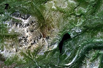
Geographische Lage Yukon, südwestlich von Whitehorse
Abfluss Two Horse Creek → Watson River → Lake Bennett
Daten
Koordinaten 60° 22′ 55″ N, 135° 21′ 10″ W60.381944444444-135.35277777778Koordinaten: 60° 22′ 55″ N, 135° 21′ 10″ W
Alligator Lake (Kanada)
Alligator Lake
Fläche 6 km²f5
Länge 6,3 kmf6

Der Alligator Lake ist ein im Süden Yukons gelegener Bergsee. Er ist 6,3 km lang und etwa 6 km² groß. Der See liegt 38 km süd-südwestlich von Whitehorse und 16 km süd-südöstlich des Ibex Mountain. In seiner Nachbarschaft befindet sich der nach ihm benannte Alligator Lake Volcanic Complex. Der natürliche Abfluss am nördlichen Ende des Sees ist der Two Horse Creek.

Der Alligator Lake steht unter besonderem Schutz. Daher gelten dort für den Angelsport besondere Regeln.[1]

Einzelnachweise

  1. Fischereiregeln

Weblinks


Wikimedia Foundation.

Игры ⚽ Нужно сделать НИР?

Schlagen Sie auch in anderen Wörterbüchern nach:

  • Alligator Lake — ist der Name von Seen in Kanada: in Ontario, siehe Alligator Lake (Ontario), im Yukon Territory, siehe Alligator Lake (Yukon), in den Vereinigten Staaten: Alligator Lake (Anderson County, Texas) Alligator Lake (Beauregard Parish, Merryville South …   Deutsch Wikipedia

  • Alligator Lake Volcanic Complex — Alligator Lake Luftaufnahme des Alligator Lake Höhe 2.217  …   Deutsch Wikipedia

  • Alligator Lake — Infobox Mountain Name=Alligator Lake Photo= Alligator Lake.jpg Caption= Aerial photo of the Alligator Lake volcanic field Elevation=Unit m|2217|0 Location=Yukon, Canada Range= Prominence = Coordinates = coord|60|42|N|135|42|W|type:mountain region …   Wikipedia

  • Complexe volcanique d'Alligator Lake — Image satellite du complexe volcanique d Alligator Lake visible dans le centre de l image (tâches brunes) non loin du lac Alligator. Géographie Altit …   Wikipédia en Français

  • Lac Alligator (Yukon) — Pour les articles homonymes, voir Alligator (homonymie). Lac Alligator Image satellite du lac Alligator …   Wikipédia en Français

  • Geography of Yukon — The Yukon is in the northwestern corner of Canada. The sparsely populated territory abounds with natural scenic beauty, with snowmelt lakes and perennial whitecapped mountains, including many of Canada s highest mountains. Although the climate is …   Wikipedia

  • List of reported lake monsters — Below is a list of lake monsters that have been reported worldwide in lakes, reservoirs, ponds and marshes, containing the names of the lakes and reported lake monsters. River monsters and lagoon monsters are not included, nor are confirmed or… …   Wikipedia

  • Liste von Flüssen in den Vereinigten Staaten — Die folgende Liste zeigt eine Vielzahl von Flüssen in den Vereinigten Staaten und deren Territorien auf Inhaltsverzeichnis A B C D E F G H I J K L M N O P Q R S T …   Deutsch Wikipedia

  • Liste von Vulkanen in Kanada —  Karte mit allen Koordinaten: OSM, Google oder …   Deutsch Wikipedia

  • Miles Canyon Basalts — Coordinates: 60°39′41.41″N 135°1′42.64″W / 60.6615028°N 135.0285111°W / 60.6615028; 135.0285111 The Miles Canyon Basalts is a clu …   Wikipedia

Share the article and excerpts

Direct link
Do a right-click on the link above
and select “Copy Link”