- Amphoe Khun Yuam
-
Khun Yuam
ขุนยวมProvinz: Mae Hong Son Fläche: 1698,3 km² Einwohner: 21.479 (2005) Bev.dichte: 12,6 E./km² PLZ: 58140 Geocode: 5802 Karte 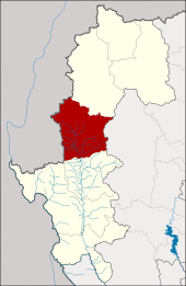
Amphoe Khun Yuam (in Thai อำเภอ ขุนยวม) ist ein Landkreis (Amphoe - Verwaltungs-Distrikt) der Provinz Mae Hong Son. Die Provinz Mae Hong Son liegt in der Nordregion von Thailand.
Inhaltsverzeichnis
Geographie
Benachbarte Bezirke (von Norden im Uhrzeigersinn): Amphoe Mueang Mae Hong Son der Provinz Mae Hong Son Province, Amphoe Mae Chaem in der Provinz Chiang Mai, AmphoeMae La Noi wiederum in Mae Hong Son sowie der Kayah-Staat von Myanmar.
Der Wasserfall Mae Surin im Nationalpark Namtok Mae Surin liegt in diesem Landkreis.
Geschichte
Mueang Khun Yuam wurde im Jahr 1910 zu einem Landkreis (Amphoe) erhoben. Khun Det Pracharak (ขุนเดชประชารักษ์) hieß der erste Leiter der Kreisverwaltung.
Verwaltung
Amphoe Khun Yuam ist in sechs Gemeinden (Tambon) eingeteilt, welche weiterhin in 45 Dörfer (Muban) unterteilt sind.
Die Kleinstadt (Thesaban Tambon) Khun Yuam (Thai: เทศบาลตำบลขุนยวม) besteht aus Teilen des Tambon Khun Yuam.
Außerdem gibt es sechs „Tambon Administrative Organizations“ (TAO, องค์การบริหารส่วนตำบล - Verwaltungs-Organisationen) im Landkreis.
Nr. Name Thai Muban Einw. 1. Khun Yuam ขุนยวม 6 6.823 2. Mae Ngao แม่เงา 10 3.068 3. Mueang Pon เมืองปอน 10 4.437 4. Mae Yuam Noi แม่ยวมน้อย 8 2.464 5. Mae Ki แม่กิ๊ 5 1.404 6. Mae Ukho แม่อูคอ 6 3.283 Weblinks
- Weitere Informationen zu Amphoe Khun Yuam von amphoe.com (in Thai)
- Webseite der Kreisverwaltung (in Thai)
- Beschreibung des Nationalparks Namtok Mae Surin (in Englisch)
 Amphoe von Mae Hong Son
Amphoe: Mueang Mae Hong Son | Khun Yuam | Pai | Mae Sariang | Mae La Noi | Sop Moei | Pang Mapha
Wikimedia Foundation.
Schlagen Sie auch in anderen Wörterbüchern nach:
Amphoe Khun Yuam — Admin ASC 2 Code Orig. name Amphoe Khun Yuam Country and Admin Code TH.01.1152764 TH … World countries Adminstrative division ASC I-II
Amphoe Khun Yuam — Infobox Amphoe name=Khun Yuam thai=ขุนยวม province=Mae Hong Son coordinates=coord|18|50|22|N|97|57|5|E|type:admnin2nd region:TH area=1,698.3 population=21,479 population as of=2005 density=12.6 postal code=58140 geocode=5802Khun Yuam ( th.… … Wikipedia
Khun Yuam — Original name in latin Khun Yuam Name in other language Amphoe Khun Yuam, Ban Khun Yuam, Khun Yuam, Mong Kum Yuam, Mng Kum Yuam, khunywm State code TH Continent/City Asia/Bangkok longitude 18.82958 latitude 97.93347 altitude 620 Population 0 Date … Cities with a population over 1000 database
Khun — bezieht sich auf mehrere thailändische Wörter: Khun (คูน, langer Vokal, mittlerer Ton) ist der Name für die Röhren Kassie Khun (คุณ, kurzer Vokal, mittlerer Ton) ist die höfliche Form der persönlichen Anrede (dem deutschsprachigen Sie, Herr, Frau … Deutsch Wikipedia
Amphoe Mae La Noi — Mae La Noi แม่ลาน้อย Provinz: Mae Hong Son Fläche: 1456,6 km² Einwohner: 34.126 (2005) Bev.dichte: 23,4 E./km² PLZ: 58120 … Deutsch Wikipedia
Amphoe Mueang Mae Hong Son — Mueang Mae Hong Son เมืองแม่ฮ่องสอน Provinz: Mae Hong Son Fläche: 2483,115 km² Einwohner: 53.333 (2010) Bev.dichte: 22,2 E./km² PLZ … Deutsch Wikipedia
Amphoe Sop Moei — Sop Moei สบเมย Provinz: Mae Hong Son Fläche: 1412,7 km² Einwohner: 41.726 (2005) Bev.dichte: 29,5 E./km² PLZ: 58110 … Deutsch Wikipedia
Amphoe Mae Sariang — Mae Sariang แม่สะเรียง Provinz: Mae Hong Son Fläche: 2.587,4 km² Einwohner: 52.024 (2005) Bev.dichte: 20,1 E./km² PLZ: 581 … Deutsch Wikipedia
Amphoe Mae La Noi — Infobox Amphoe name=Mae La Noi thai=แม่ลาน้อย province=Mae Hong Son coordinates=coord|18|23|4|N|97|56|13|E|type:adm2nd region:TH capital=Mae La Noi area=1,456.6 population=34,126 population as of=2005 density=23.4 postal code=58120… … Wikipedia
Amphoe Mueang Mae Hong Son — Infobox Amphoe name=Mueang Mae Hong Son thai=เมืองแม่ฮ่องสอน province=Mae Hong Son coordinates=coord|19|18|14|N|97|58|38|E|type:adm2nd region:TH area=2,483.115 population=55,020 population as of=2005 density=22.2 postal code=58000… … Wikipedia
Amphoe Khun Yuam


18+
© Academic, 2000-2024
- Kontaktieren Sie uns: Unterstützung, Werbung
Wörterbücher Export, schritte mit PHP, Joomla, Drupal, WordPress, MODx.