- An Dún
-
County Down Karte 
Basisdaten Staat: Vereinigtes Königreich Verwaltungssitz: Downpatrick Provinz: Ulster irischer Name: An Dún Fläche: 2465 km² Einwohner: 454.000 (Schätzung) Down (irisch: An Dún) ist eine der sechs historischen Grafschaften (Countys) Nordirlands.
Inhaltsverzeichnis
Geografie
Das County liegt zwischen dem Carlingford Lough, dem Fluss Bann, Belfast Lough und der Irischen See. Die Landschaft ist durch die letzte Eiszeit geprägt. Höhere Erhebungen gibt es nur im Süden mit den Mourne Mountains und in Zentral-Down mit dem Clieve Croob.
Geschichte
Die Grafschaft hat eine lange Vorgeschichte, in der der Bau von Megalithanlagen eine herausragende Rolle spielt. Die Geschichte von Down ist bis zur Teilung der Insel Teil der Geschichte Irlands; siehe dort.
Wirtschaft
25 Prozent der landwirtschaftlichen Fläche werden für den Ackerbau (Gerste, Kartoffeln, Gemüse) genutzt, 75 Prozent für Viehhaltung (Rinder, Schweine, Geflügel, Schafe). Entlang der Küste wird Fischfang betrieben und es liegen dort mehrere bedeutende Seebäder.
In der Umgebung von Belfast ist die Industrie konzentriert. Vorrangig existiert eine Maschinenbau-, Elektro- und Computer- sowie Textilindustrie.
Städte
- Banbridge
- Bangor
- Comber
- Downpatrick
- Dromore
- Dundonald
- Holywood
- Lisburn (gehört teilweise zum County Antrim)
- Newry
- Newtownards
Sehenswürdigkeiten
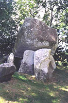 Portal tomb Goward mit dem für diese Gattung typischen riesigen Deckstein
- Annadorn (Dolmen)
- Audleystown (Cairn)
- Ballynoe (Steinkreis)
- Dunnaman Court tomb
- The Giant’s Ring (Steinkreis)
- Goward Portal tomb
- Kilfeaghan (Dolmen)
- Kilteagh (Dolmen)
- Legananny (Dolmen)
- Millin Bay (Cairn)
- Inch Abbey
Persönlichkeiten
- Robert Ross, Offizier der britischen Royal Army (1766–1814)
- Robert Stewart, 2. Marquess of Londonderry, britischer Staatsmann (1769–1822)
- Francis Crozier, Offizier der britischen Royal Navy und Polarfahrer (1796–1848)
- Arthur Kennedy, Politiker und britischer Kolonialbeamter (1809–1883)
- Colin Blakely, Schauspieler (1930–1987)
- Pat Jennings, Fußballspieler (* 1945)
- Rose Marie, Sängerin (* 1956)
- Gary Lightbody, Sänger und Frontmann der Rockband Snow Patrol (* 1976)
 Historische Grafschaften (counties) von Nordirland
Antrim | Armagh | Down | Fermanagh | Londonderry | Tyrone

Wikimedia Foundation.