- Kennon Island
-
Kennon Island Gewässer Beringmeer Geographische Lage 52° 56′ 20″ N, 173° 15′ 18″ O52.938888888889173.255Koordinaten: 52° 56′ 20″ N, 173° 15′ 18″ O 

Einwohner (unbewohnt) Karte vom Nordosten von Attu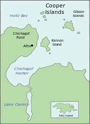
Kennon Island ist eine Insel in der Mündung des Chichagof Harbor auf der Nordost-Seite von Attu, der größten Insel der Near Islands in den Aleuten. Die Insel wurde im Juli 1855 bei der North Pacific Surveying Expedition von Lt. William Gibson, USN, Kommandant des Schoners USS Fenimore Cooper, nach Lt. Beverly Kennon benannt.
Inseln der Near IslandsAgattu | Alaid | Attu | Cooper Islands | Gibson Islands | Hammerhead | Hodikof | Kennon | Kohl | Loaf | Lotus | Nizki | Peaked | Savage | Semichi Islands | Shemya
Wikimedia Foundation.
Schlagen Sie auch in anderen Wörterbüchern nach:
Kennon Island — (52°56N 173°15E) is a 0.3 mi long satellite of Attu Island in the Near Islands group at the extreme western end of the Aleutian Islands, Alaska. It is located 0.5 mi off the east side of Attu in Chichagof Bay. It was named by Lt. William Gibson… … Wikipedia
Kennon — ist der Familienname folgender Personen: Robert F. Kennon (Robert Floyd Kennon, Sr.; 1902–1988), US amerikanischer Politiker und von 1952 bis 1956 Gouverneur des Bundesstaates Louisiana Siehe auch: Kennon Island Kennon Observatory, astronomisches … Deutsch Wikipedia
Attu Island — Dieser Artikel oder Abschnitt ist nicht hinreichend mit Belegen (Literatur, Webseiten oder Einzelnachweisen) versehen. Die fraglichen Angaben werden daher möglicherweise demnächst gelöscht. Hilf Wikipedia, indem du die Angaben recherchierst und… … Deutsch Wikipedia
Nizki Island — Vorlage:Infobox Insel/Wartung/Fläche fehlt Nizki Island Karte von Nizki Island Gewässer Nordpazifik … Deutsch Wikipedia
Shemya Island — Vorlage:Infobox Insel/Wartung/Höhe fehlt Shemya Island Luftbild von Shemya Gewässer Pazifischer Ozean … Deutsch Wikipedia
Alaid Island — Topographisches Kartenblatt Gewässer Pazifischer Ozean, Beringsee … Deutsch Wikipedia
Kohl Island — Vorlage:Infobox Insel/Wartung/Bild fehltVorlage:Infobox Insel/Wartung/Fläche fehltVorlage:Infobox Insel/Wartung/Höhe fehlt Kohl Island Gewässer Beringmeer Inselgruppe Near Islands … Deutsch Wikipedia
Lotus Island — Vorlage:Infobox Insel/Wartung/Bild fehltVorlage:Infobox Insel/Wartung/Fläche fehltVorlage:Infobox Insel/Wartung/Höhe fehlt Lotus Island Gewässer Beringmeer Inselgruppe Semichi Islands … Deutsch Wikipedia
Peaked Island — Vorlage:Infobox Insel/Wartung/Bild fehltVorlage:Infobox Insel/Wartung/Fläche fehltVorlage:Infobox Insel/Wartung/Höhe fehlt Peaked Island Gewässer Beringmeer Inselgruppe Near Islands … Deutsch Wikipedia
Agattu Island — Ein Stellerscher Seelöwe auf Agattu Gewässer Pazifischer Ozean … Deutsch Wikipedia
Kennon Island


18+
© Academic, 2000-2024
- Kontaktieren Sie uns: Unterstützung, Werbung
Wörterbücher Export, schritte mit PHP, Joomla, Drupal, WordPress, MODx.