- Anibare
-
Lage Anibares 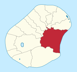
Fläche Rang (innerhalb Naurus) 1 (von 14) Insgesamt 3,1 km² Einwohner Rang (innerhalb Naurus) 13 (von 14) Insgesamt Stand (2004) 259 Dichte 84 Einwohner/km² Geographie Zeitzone UTC +12 Geographische Lage 1° S, 167° O-0.533333166.95Koordinaten: 1° S, 167° O Breite ca. 1,8 km Länge ca. 2,2 km Höchste Lage ca. 40 m Durchschnittliche Lage ca. 30 m Tiefste Lage ca. 0 m 
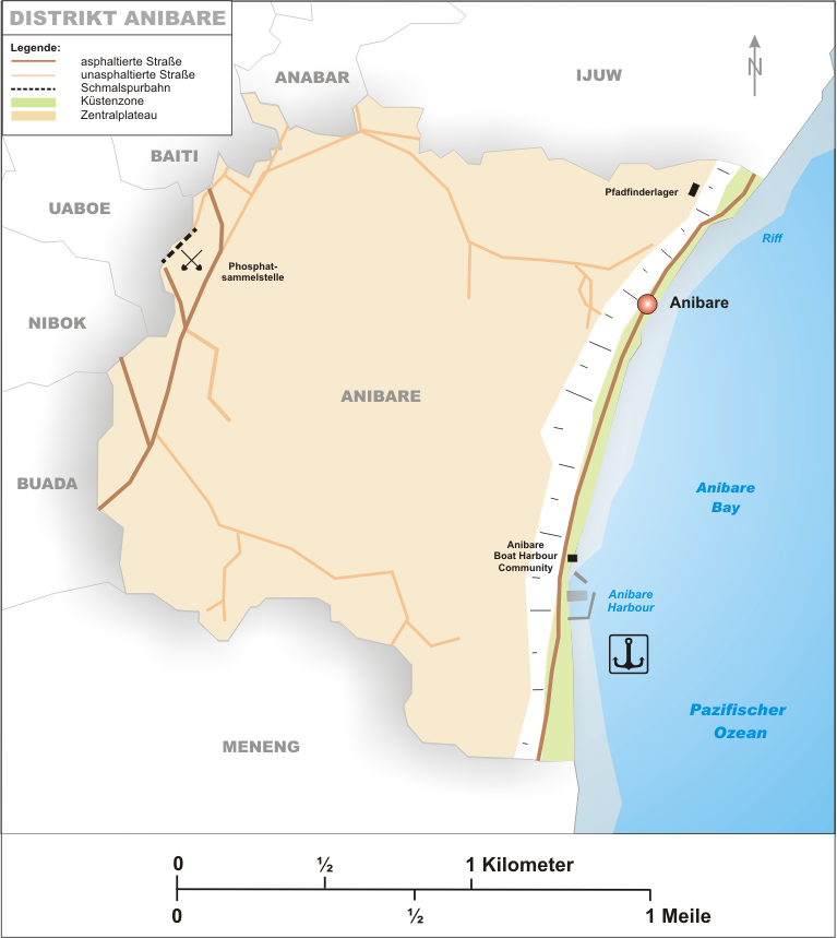
Anibare ist ein Distrikt auf dem Inselstaat Nauru. Es ist ein Teil des Wahlkreises Anabar. Die ganze Küstenlinie besteht aus dem Strand der Anibare Bay. Auf der südlichen Hälfte des Strandes wurde 2000 der Anibare Harbour gebaut. Im Westen Anibares befindet sich der Sammelplatz des abgebauten Phosphats, welches von dort aus per Eisenbahn nach Aiwo zur Verschiffung transportiert wird.
Anibare bedeutet gemäß Paul Hambruch „viele Geister“; womöglich ist der Name darauf zurückzuführen, dass in der nauruischen Mythologie der Eingang zur Geisterinsel Buitani, welche die Unterwelt darstellt, sich in Anibare befindet.
Anibare befindet sich Osten Naurus, und ist 3,1 km² groß. Es hat 260 Einwohner. Es grenzt im Süden an Meneng, im Westen an Buada, Nibok und Uaboe, im Nordwesten an Baiti und im Norden an Anabar und Ijuw.
Historische Dörfer
Bis 1968 war der heutige Distrikt Anibare ein Gau, welcher aus 17 historischen Dörfern bestand.
- Adreyi
- Agabwe
- Anakawidua
- Anera
- Anitobu
- Aribeang
- Ate
- Boneda
- Bweranibek
- Bweteboe
- Bweteoaru
- Eatedogi
- Etamor
- Gene
- Kawinanut
- Merubo
- Yanmwitebwiyeye
Schlagen Sie auch in anderen Wörterbüchern nach:
Anibare — Saltar a navegación, búsqueda Anibare Distrito de Nauru … Wikipedia Español
Anibare — may refer to: * Anibare District * Anibare Bay … Wikipedia
Anibare — es un distrito de Nauru. Está ubicado en el este de la isla, con una superficie de 3,1 km² y una población de 250 habitantes … Enciclopedia Universal
Anibare — 0°31′38″S 166°56′51″E / 0.52722, 166.9475 … Wikipédia en Français
Anibare — Original name in latin Anibare Name in other language Anibare, Enniberri State code NR Continent/City Pacific/Nauru longitude 0.52792 latitude 166.95249 altitude 8 Population 0 Date 2013 07 04 … Cities with a population over 1000 database
Anibare — Admin ASC 1 Code Orig. name Anibare Country and Admin Code NR.04 NR … World countries Adminstrative division ASC I-II
Anibare Bay — is the only bay of Nauru in the east of the island nation. It is one of the locations in Nauru which are visited by tourists.The beach of the same name is covered with white coral sand. It is located in the Anibare District. The capes, which form … Wikipedia
Anibare District — Anibare is a district in the island nation Nauru. It s a part of the Anabar Constituency.TourismIn this district is the best beach of the island at Anibare Bay. It s a beach with white coral sand and the best place on the island to surf or to… … Wikipedia
Anibare Bay — Die Anibare Bucht ist die einzige Bucht Naurus im Osten des Inselstaates. Hier bietet sich der touristisch reizvollste Aspekt Naurus. Der gleichnamige Strand ist mit weißem Korallensand bedeckt. Er befindet sich nahezu vollständig im Distrikt… … Deutsch Wikipedia
Anibare-Bucht — 0.53361111111111166.95555555556 … Deutsch Wikipedia
Anibare

18+
© Academic, 2000-2024
- Kontaktieren Sie uns: Unterstützung, Werbung
Wörterbücher Export, schritte mit PHP, Joomla, Drupal, WordPress, MODx.