- La Crosse County
-
 Das La Crosse County Courthouse in La Crosse
Verwaltung US-Bundesstaat: Wisconsin Verwaltungssitz: La Crosse Adresse des
Verwaltungssitzes:County Courthouse
400, 4th Street North
La Crosse, WI 54601-0000Gründung: 1. März 1851 Gebildet aus: Crawford County Vorwahl: 001 608 Demographie Einwohner: 114.638 (2010) Bevölkerungsdichte: 97,7 Einwohner/km² Geographie Fläche gesamt: 1.243 km² Wasserfläche: 70 km² Karte 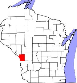
Website: www.co.la-crosse.wi.us La Crosse County[1] ist ein County im Bundesstaat Wisconsin der Vereinigten Staaten von Amerika. Bei der Volkszählung im Jahr 2010 hatte das County 114.638 Einwohner und eine Bevölkerungsdichte von 97,7 Einwohnern pro Quadratkilometer. Der Verwaltungssitz (County Seat) ist La Crosse.
Inhaltsverzeichnis
Geografie
Das County liegt im Südwesten von Wisconsin, grenzt an Minnesota, getrennt durch den Mississippi River, der die natürliche Grenze bildet und hat eine Fläche von 1243 Quadratkilometern, wovon 70 Quadratkilometer Wasserfläche sind. Es grenzt an folgende Countys:
Trempealeau County Jackson County Winona County
(Minnesota)
Monroe County Houston County
(Minnesota)Vernon County Geschichte
La Crosse County wurde am 1. März 1851 aus Teilen des Crawford County gebildet. Benannt wurde es, ebenso wie die Bezirkshauptstadt, nach einem Spiel, das die Indianer hier spielten.
Demografische Daten
Historische Einwohnerzahlen Census Einwohner ± in % 1900 42.997 — 1910 43.996 2 % 1920 44.355 0,8 % 1930 54.455 20 % 1940 59.653 10 % 1950 67.587 10 % 1960 72.465 7 % 1970 80.468 10 % 1980 91.056 10 % 1990 97.904 8 % 2000 107.120 9 % 2010 114.638 7 % 1900–1990[2] 2010[3]  Alterspyramide (2000) des La Crosse County
Nach der Volkszählung im Jahr 2000 lebten im La Crosse County 107.120 Menschen in 41.599 Haushalten. 25.583 Familien lebten im County. Die Bevölkerungsdichte betrug 91 Personen pro Quadratkilometer. Ethnisch betrachtet setzte sich die Bevölkerung zusammen aus 94,18 Prozent Weißen, 0,95 Prozent Afroamerikanern, 0,41 Prozent amerikanischen Ureinwohnern, 3,15 Prozent Asiaten, 0,02 Prozent Bewohnern aus dem pazifischen Inselraum und 0,27 Prozent aus anderen ethnischen Gruppen; 1,03 Prozent stammten von zwei oder mehr Ethnien ab. 0,92 Prozent der Bevölkerung waren spanischer oder lateinamerikanischer Abstammung, die verschiedenen der genannten Gruppen angehörten.
Von den 41.599 Haushalten hatten 29,9 Prozent Kinder unter 18 Jahren, die mit ihnen zusammen lebten. 50,0 Prozent davon waren verheiratete, zusammenlebende Paare, 8,4 Prozent waren allein erziehende Mütter. 38,5 Prozent waren keine Familien. 28,4 Prozent waren Singlehaushalte und in 9,8 Prozent lebten Menschen mit 65 Jahren oder älter. Die durchschnittliche Haushaltsgröße lag bei 2,45 und die durchschnittliche Familiengröße bei 3,02 Personen.
23,6 Prozent der Bevölkerung waren unter 18 Jahre alt, 15,6 Prozent zwischen 18 und 24, 27,5 Prozent zwischen 25 und 44, 20,8 Prozent zwischen 45 und 64, und 12,5 Prozent waren 65 Jahre oder älter. Das Durchschnittsalter betrug 34 Jahre. Auf 100 weibliche kamen statistisch 94,1 männliche Personen.[4]
Städte und Gemeinden
- Bangor
- Holmen
- La Crosse
- Onalaska
- Rockland
- West Salem
Einzelnachweise
- ↑ La Crosse County im Geographic Names Information System des United States Geological Survey Abgerufen am 22. Februar 2011
- ↑ Auszug aus Census.gov Abgerufen am 28. Februar 2011
- ↑ United States Census 2010 Abgerufen am 8. April 2011
- ↑ La Crosse County, Wisconsin Datenblatt mit den Ergebnissen der Volkszählung im Jahre 2000 bei factfinder.census.gov
Weblinks
-
 Commons: La Crosse County, Wisconsin – Sammlung von Bildern, Videos und Audiodateien
 - Offizielle Webseite
- www.city-data.com

Liste der Countys in Wisconsin
Adams | Ashland | Barron | Bayfield | Brown | Buffalo | Burnett | Calumet | Chippewa | Clark | Columbia | Crawford | Dane | Dodge | Door | Douglas | Dunn | Eau Claire | Florence | Fond du Lac | Forest | Grant | Green | Green Lake | Iowa | Iron | Jackson | Jefferson | Juneau | Kenosha | Kewaunee | La Crosse | Lafayette | Langlade | Lincoln | Manitowoc | Marathon | Marinette | Marquette | Menominee | Milwaukee | Monroe | Oconto | Oneida | Outagamie | Ozaukee | Pepin | Pierce | Polk | Portage | Price | Racine | Richland | Rock | Rusk | Sauk | Sawyer | Shawano | Sheboygan | St. Croix | Taylor | Trempealeau | Vernon | Vilas | Walworth | Washburn | Washington | Waukesha | Waupaca | Waushara | Winnebago | Wood
Wikimedia Foundation.
Schlagen Sie auch in anderen Wörterbüchern nach:
La Crosse County — Admin ASC 2 Code Orig. name La Crosse County Country and Admin Code US.WI.063 US … World countries Adminstrative division ASC I-II
National Register of Historic Places listings in La Crosse County, Wisconsin — Map of all coordinates from Google Map of all coordinates from Bing … Wikipedia
La Crosse County, Wisconsin — Infobox U.S. County county = La Crosse County state = Wisconsin map size = 225 founded = 1851 seat = La Crosse | area total sq mi =480 area land sq mi =453 area water sq mi =27 area percentage = 5.66% census yr = 2006 pop = 109404 density km2 =91 … Wikipedia
Holland, La Crosse County, Wisconsin — Infobox Settlement official name = Holland, Wisconsin settlement type = Town nickname = motto = imagesize = image caption = image mapsize = 250px map caption = Location of Holland, Wisconsin mapsize1 = map caption1 = subdivision type = Country… … Wikipedia
La Crosse County Historical Society — The La Crosse County Historical Society is an organization dedicated to the preservation of history in La Crosse County, Wisconsin. The society has a museum, offices, and a number of historical sites in La Crosse, Wisconsin; it was founded in… … Wikipedia
Farmington, La Crosse County, Wisconsin — Infobox Settlement official name = Farmington, Wisconsin settlement type = Town nickname = motto = imagesize = image caption = image mapsize = 250px map caption = Location of Farmington, Wisconsin mapsize1 = map caption1 = subdivision type =… … Wikipedia
Greenfield, La Crosse County, Wisconsin — Infobox Settlement official name = Greenfield, Wisconsin settlement type = Town nickname = motto = imagesize = image caption = image mapsize = 250px map caption = Location of Greenfield, Wisconsin mapsize1 = map caption1 = subdivision type =… … Wikipedia
Washington, La Crosse County, Wisconsin — Infobox Settlement official name = Washington, Wisconsin settlement type = Town nickname = motto = imagesize = image caption = image mapsize = 250px map caption = Location of Washington, Wisconsin mapsize1 = map caption1 = subdivision type =… … Wikipedia
County surveyor — Table of Surveying, from the 1728 Cyclopaedia, Volume 2 … Wikipedia
La Crosse, Wisconsin — Infobox Settlement official name = La Crosse, Wisconsin settlement type = City imagesize = image caption = image mapsize = 250px map caption = Location in the state of Wisconsin mapsize1 = map caption1 = subdivision type = Country subdivision… … Wikipedia
La Crosse County


18+
© Academic, 2000-2024
- Kontaktieren Sie uns: Unterstützung, Werbung
Wörterbücher Export, schritte mit PHP, Joomla, Drupal, WordPress, MODx.